TopoQuest Logo
Do you find TopoQuest useful?
Help keep TopoQuest running and adding new maps/features by donating!
Bitcoin:  19c7KJd3qBynnjoSw5npx9KScwjBe4ifkT
Litecoin:  LXs6TkuXGGXo1vDsWCkWVdjQX94eUKd6ui
Home View Maps Find Maps Find Places Resources & Links


Conifer, Colorado Topographic Map

USGS Map Title: Conifer, CO
USGS Map MRC: 39105E3
DRG (GeoTIFF) Download: o39105e3.tif


Neighboring USGS Topographic Map Quads:


  Squaw Pass, CO  
39105F4
 

  Evergreen, CO  
39105F3
 

  Morrison, CO  
39105F2
 

  Meridian Hill, CO  
39105E4
 

  Conifer, CO  
39105E3
 

  Indian Hills, CO  
39105E2
 

  Bailey, CO  
39105D4
 

  Pine, CO  
39105D3
 

  Platte Canyon, CO  
39105D2


Map MRC Location:

N40°
W106°
N40°
W105°
H8 H7 H6 H5 H4 H3 H2 H1
G8 G7 G6 G5 G4 G3 G2 G1
F8 F7 F6 F5 F4 F3 F2 F1
E8 E7 E6 E5 E4 E3 E2 E1
D8 D7 D6 D5 D4 D3 D2 D1
C8 C7 C6 C5 C4 C3 C2 C1
B8 B7 B6 B5 B4 B3 B2 B1
A8 A7 A6 A5 A4 A3 A2 A1
N39°
W106°
N39°
W105°

Conifer, CO USGS 1:24K Topographic Map Preview:
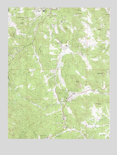
Conifer, CO USGS Topographic Map
Click on map above to begin viewing in our Map Viewer.

This topographic map contains these locations and features:
Feature Name Type Latitude Longitude GNIS ID View Map
Annie MineMineN39.5019°W105.3125°1735886View Map
Aspen ParkPopulated PlaceN39.5392°W105.2947°182542View Map
Aspen Park Census Designated PlaceCensusN39.5423°W105.2968°2407775View Map
Atlantic MineMineN39.5030°W105.2936°1735888View Map
Augusta MineMineN39.6178°W105.3175°182560View Map
Bell ParkParkN39.6208°W105.3039°182561View Map
Berrian MountainSummitN39.5550°W105.2922°182549View Map
Blue CreekStreamN39.5908°W105.3453°182551View Map
Broken Arrow AcresPopulated PlaceN39.5028°W105.3267°202933View Map
Camp NewtonLocaleN39.5108°W105.3058°182540View Map
Casto CreekStreamN39.5086°W105.2972°183300View Map
ConiferPopulated PlaceN39.5211°W105.3053°204717View Map
Conifer CemeteryCemeteryN39.5173°W105.3042°2734657View Map
Conifer Post OfficePost OfficeN39.5438°W105.2955°2734588View Map
Cub Creek ParkParkN39.6164°W105.3239°182559View Map
Denver Mountain Park SiteParkN39.5589°W105.2969°182532View Map
Doublehead MountainSummitN39.5625°W105.2611°182550View Map
Elk Creek Fire / Rescue Station 3BuildingN39.5179°W105.3532°2368779View Map
Elk Creek Fire / Rescue Station 4BuildingN39.5403°W105.2967°2368780View Map
Evergreen Fire / Rescue Station 3BuildingN39.5904°W105.3096°2368771View Map
Evergreen Fire / Rescue Station 4BuildingN39.6189°W105.3186°2368772View Map
Evergreen Fluorite Deposit MineMineN39.6125°W105.3283°1703695View Map
Evergreen Meadows QuarryMineN39.5211°W105.3053°1703696View Map
Evergreen Memorial Park CemeteryCemeteryN39.5858°W105.3064°182563View Map
Evergreen MountainSummitN39.6105°W105.3608°182553View Map
Flying J Ranch Airport (historical)AirportN39.5425°W105.3178°204391View Map
Green Valley AcresPopulated PlaceN39.5022°W105.3119°182539View Map
Herzman MesaPopulated PlaceN39.6105°W105.3103°182558View Map
James Q Newton ParkParkN39.5117°W105.2961°182541View Map
Jefferson CountyCivilN39.5864°W105.2505°198145View Map
Kinney PeakSummitN39.6053°W105.3047°182557View Map
Lans GulchValleyN39.6141°W105.3302°182556View Map
Legault MountainSummitN39.5336°W105.2650°182548View Map
Lone PeakSummitN39.6044°W105.2636°182565View Map
MarshdalePopulated PlaceN39.5925°W105.3122°182555View Map
Marshdale AirportAirportN39.5835°W105.2985°204390View Map
Maxwell CreekStreamN39.5794°W105.3680°182530View Map
Meyer Ranch Airport (historical)AirportN39.5503°W105.2807°204321View Map
Oehlmann ParkPopulated PlaceN39.5189°W105.2592°182547View Map
Our Lady of the Rockies CampLocaleN39.5972°W105.3750°202883View Map
Pleasant ParkFlatN39.5128°W105.2703°182545View Map
Pleasant Park CemeteryCemeteryN39.5189°W105.2692°182546View Map
Pleasant Park GrangeLocaleN39.5042°W105.2592°182544View Map
Rossman GulchValleyN39.5858°W105.2592°1854203View Map
SprucedalePopulated PlaceN39.5889°W105.3522°182552View Map
Stanley ParkPopulated PlaceN39.6183°W105.2928°182562View Map
West Jefferson Elementary SchoolSchoolN39.5393°W105.3039°2439189View Map
Wild Rose GrangeLocaleN39.5880°W105.2628°182566View Map
Wilmot Elementary SchoolSchoolN39.6208°W105.3379°182554View Map

Note: Coordinates in the location and feature list above are referenced to NAD83 datum.


Copyright (C) 2008-2024 Ryan Niemi / Sunset Dynamics ... All Rights Reserved