TopoQuest Logo
Do you find TopoQuest useful?
Help keep TopoQuest running and adding new maps/features by donating!
Bitcoin:  19c7KJd3qBynnjoSw5npx9KScwjBe4ifkT
Litecoin:  LXs6TkuXGGXo1vDsWCkWVdjQX94eUKd6ui
Home View Maps Find Maps Find Places Resources & Links


Camp Austin, Tennessee Topographic Map

USGS Map Title: Camp Austin, TN
USGS Map MRC: 36084A5
DRG (GeoTIFF) Download: o36084a5.tif


Neighboring USGS Topographic Map Quads:


  Pilot Mountain, TN  
36084B6
 

  Gobey, TN  
36084B5
 

  Fork Mountain, TN  
36084B4
 

  Lancing, TN  
36084A6
 

  Camp Austin, TN  
36084A5
 

  Petros, TN  
36084A4
 

  Cardiff, TN  
35084H6
 

  Harriman, TN  
35084H5
 

  Elverton, TN  
35084H4


Map MRC Location:

N37°
W85°
N37°
W84°
H8 H7 H6 H5 H4 H3 H2 H1
G8 G7 G6 G5 G4 G3 G2 G1
F8 F7 F6 F5 F4 F3 F2 F1
E8 E7 E6 E5 E4 E3 E2 E1
D8 D7 D6 D5 D4 D3 D2 D1
C8 C7 C6 C5 C4 C3 C2 C1
B8 B7 B6 B5 B4 B3 B2 B1
A8 A7 A6 A5 A4 A3 A2 A1
N36°
W85°
N36°
W84°

Camp Austin, TN USGS 1:24K Topographic Map Preview:
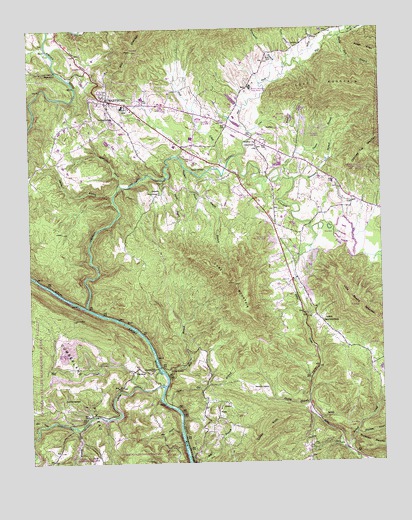
Camp Austin, TN USGS Topographic Map
Click on map above to begin viewing in our Map Viewer.

This topographic map contains these locations and features:
Feature Name Type Latitude Longitude GNIS ID View Map
Armes Chapel CemeteryCemeteryN36.0781°W84.5785°1646597View Map
Bardill BranchStreamN36.0823°W84.5752°1304953View Map
Bear CreekStreamN36.0115°W84.6183°1276595View Map
Beech ForkStreamN36.0590°W84.5016°1276815View Map
Bolton BranchStreamN36.1156°W84.5299°1277913View Map
Bonafacius BranchStreamN36.0798°W84.5927°1277928View Map
Brasel BranchStreamN36.1137°W84.5338°1269375View Map
Breedlove BranchStreamN36.0848°W84.5691°1278277View Map
Brushy Mountain State Honor FarmLocaleN36.1081°W84.5460°1305479View Map
Camp AustinLocaleN36.0267°W84.5763°1305618View Map
Camp Austin CemeteryCemeteryN36.0265°W84.5833°1646605View Map
Central Elementary SchoolSchoolN36.1029°W84.5916°1309641View Map
Central High SchoolSchoolN36.1051°W84.5844°1309642View Map
City of WartburgCivilN36.1043°W84.5864°2405678View Map
Civilian Conservation Corps Camp Number 1463 (historical)LocaleN36.1223°W84.6222°1309644View Map
Coal Cut BranchStreamN36.0167°W84.5760°1306001View Map
Commissioner District 3CivilN36.1056°W84.5815°2464182View Map
Cooke KnobSummitN36.0109°W84.5391°1281133View Map
Cow BranchStreamN36.0092°W84.5719°1281441View Map
Crab Orchard CreekStreamN36.0223°W84.5772°1281521View Map
Crooked ForkStreamN36.0448°W84.6052°1306187View Map
DeermontPopulated PlaceN36.0262°W84.5888°1314941View Map
Deermont School (historical)SchoolN36.0265°W84.5885°1309653View Map
Flat ForkStreamN36.0881°W84.5513°1284389View Map
Flat Fork CemeteryCemeteryN36.1198°W84.5285°1646619View Map
Flat Fork School (historical)SchoolN36.0970°W84.5547°1309660View Map
Forked CreekStreamN36.0029°W84.5124°1284633View Map
Francis CemeteryCemeteryN36.0840°W84.5652°1284803View Map
GrovePopulated PlaceN36.0523°W84.5319°1309664View Map
Hall BranchStreamN36.0254°W84.5772°1286551View Map
Honeycutt CemeteryCemeteryN36.0137°W84.5208°1646628View Map
Honeycutt CemeteryCemeteryN36.0209°W84.5449°1288213View Map
Jones BranchStreamN36.0951°W84.5466°1289699View Map
Knight BranchStreamN36.0829°W84.5630°1290359View Map
LibertyPopulated PlaceN36.0929°W84.5444°1647203View Map
Liberty Baptist ChurchChurchN36.0923°W84.5449°1291136View Map
Liberty CemeteryCemeteryN36.0926°W84.5452°1646631View Map
Lone MountainSummitN36.0515°W84.5522°1291843View Map
Love MountainSummitN36.1070°W84.5058°1292128View Map
Melhorn FordCrossingN36.0276°W84.5797°1309674View Map
Mill CreekStreamN36.0215°W84.5855°1269804View Map
Montgomery (historical)Populated PlaceN36.1137°W84.6144°1309676View Map
Morgan County Correctional ComplexBuildingN36.1132°W84.5397°2766068View Map
Morgan County LandfillLocaleN36.1128°W84.5492°2677873View Map
Morgan County Vocational CenterSchoolN36.0992°W84.5519°1309677View Map
Morgan County Volunteer Fire DepartmentBuildingN36.1036°W84.5979°2654426View Map
Mossy Grove CemeteryCemeteryN36.0409°W84.5205°1646680View Map
Mossy Grove Primitive Baptist ChurchChurchN36.0406°W84.5210°1294517View Map
Mud CreekStreamN36.0851°W84.5552°1295006View Map
Muddy BranchStreamN36.0173°W84.5260°1295027View Map
Muddy HollowValleyN36.0172°W84.5267°1309678View Map
Oakdale Division (historical)CensusN36.0167°W84.5841°1648891View Map
Ormes ChapelChurchN36.0779°W84.5788°1296491View Map
PineyPopulated PlaceN36.0151°W84.5583°1315719View Map
Piney CemeteryCemeteryN36.0159°W84.5577°1646654View Map
Piney ChurchChurchN36.0159°W84.5580°1647205View Map
Piney School (historical)SchoolN36.0151°W84.5580°1309687View Map
Rocky Fork BranchStreamN36.1234°W84.5135°1299886View Map
Rough RidgeRidgeN36.1176°W84.5002°1303544View Map
Smith BranchStreamN36.0104°W84.6094°1270572View Map
Summers BranchStreamN36.0812°W84.5305°1271834View Map
Summers CemeteryCemeteryN36.0184°W84.6133°1303930View Map
Taylor BranchStreamN36.0815°W84.5330°1272186View Map
Tennessee Department of Agriculture Division of Forestry Morgan DistrictBuildingN36.0703°W84.5423°2654728View Map
Thorton CemeteryCemeteryN36.0965°W84.5372°1646672View Map
Vespie BranchStreamN36.0767°W84.5952°1273435View Map
WartburgPopulated PlaceN36.1048°W84.5972°1304388View Map
Wartburg Blue Gem MineMineN36.1198°W84.5888°1650019View Map
Wartburg CemeteryCemeteryN36.0990°W84.5960°1273843View Map
Wartburg Division (historical)CensusN36.1076°W84.5530°1648893View Map
Wartburg First Baptist ChurchChurchN36.1037°W84.5969°1643774View Map
Wartburg Police DepartmentBuildingN36.1054°W84.5966°2765768View Map
Wartburg Post OfficePost OfficeN36.1055°W84.5986°1650020View Map
Wartburg Volunteer Fire DepartmentBuildingN36.1008°W84.5961°2654370View Map
WECO-AM (Wartburg)TowerN36.0967°W84.5919°1639941View Map
Whetstone BranchStreamN36.0087°W84.5097°1274301View Map
White OakPopulated PlaceN36.0117°W84.6099°1309696View Map
Whiteoak SchoolSchoolN36.0117°W84.6091°1304553View Map
Winchester BranchStreamN36.1098°W84.5391°1274849View Map

Note: Coordinates in the location and feature list above are referenced to NAD83 datum.


Copyright (C) 2008-2024 Ryan Niemi / Sunset Dynamics ... All Rights Reserved