TopoQuest Logo
Do you find TopoQuest useful?
Help keep TopoQuest running and adding new maps/features by donating!
Bitcoin:  19c7KJd3qBynnjoSw5npx9KScwjBe4ifkT
Litecoin:  LXs6TkuXGGXo1vDsWCkWVdjQX94eUKd6ui
Home View Maps Find Maps Find Places Resources & Links


Gobey, Tennessee Topographic Map

USGS Map Title: Gobey, TN
USGS Map MRC: 36084B5
DRG (GeoTIFF) Download: o36084b5.tif


Neighboring USGS Topographic Map Quads:


  Rugby, TN  
36084C6
 

  Robbins, TN  
36084C5
 

  Norma, TN  
36084C4
 

  Pilot Mountain, TN  
36084B6
 

  Gobey, TN  
36084B5
 

  Fork Mountain, TN  
36084B4
 

  Lancing, TN  
36084A6
 

  Camp Austin, TN  
36084A5
 

  Petros, TN  
36084A4


Map MRC Location:

N37°
W85°
N37°
W84°
H8 H7 H6 H5 H4 H3 H2 H1
G8 G7 G6 G5 G4 G3 G2 G1
F8 F7 F6 F5 F4 F3 F2 F1
E8 E7 E6 E5 E4 E3 E2 E1
D8 D7 D6 D5 D4 D3 D2 D1
C8 C7 C6 C5 C4 C3 C2 C1
B8 B7 B6 B5 B4 B3 B2 B1
A8 A7 A6 A5 A4 A3 A2 A1
N36°
W85°
N36°
W84°

Gobey, TN USGS 1:24K Topographic Map Preview:
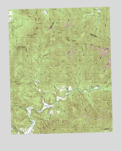
Gobey, TN USGS Topographic Map
Click on map above to begin viewing in our Map Viewer.

This topographic map contains these locations and features:
Feature Name Type Latitude Longitude GNIS ID View Map
Bear Bench RidgeRidgeN36.2190°W84.5719°1276550View Map
Beech BranchStreamN36.1431°W84.6033°1276802View Map
Big Lick GapGapN36.1776°W84.6197°1277340View Map
Cane BranchStreamN36.1598°W84.6249°1279500View Map
Cane Branch ChurchChurchN36.1565°W84.6205°1279501View Map
Caney Branch CemeteryCemeteryN36.1567°W84.6213°1646607View Map
Dry BranchStreamN36.1367°W84.5969°1282856View Map
Dry BranchStreamN36.1681°W84.5027°1282887View Map
Edmund BranchStreamN36.1681°W84.5252°1283536View Map
ElizabethPopulated PlaceN36.1542°W84.5763°1309657View Map
Elizabeth CemeteryCemeteryN36.1551°W84.5799°1646616View Map
Elizabeth ChurchChurchN36.1545°W84.5799°1647197View Map
Elizabeth SchoolSchoolN36.1562°W84.5788°1283631View Map
Emory (historical)Populated PlaceN36.1765°W84.5908°1309658View Map
Emory River Church (historical)ChurchN36.1473°W84.5997°1309659View Map
England MountainSummitN36.1484°W84.5052°1283787View Map
Fall HollowValleyN36.1765°W84.5951°1284082View Map
Fork MountainSummitN36.1962°W84.5141°1284623View Map
Freels MountainSummitN36.2340°W84.5852°1284882View Map
Gladey BranchStreamN36.2431°W84.5105°1285482View Map
GobeyPopulated PlaceN36.1490°W84.5997°1315128View Map
Gobey School (historical)SchoolN36.1492°W84.6027°1324923View Map
Gosnell BranchStreamN36.2431°W84.5252°1285729View Map
Gosnell RidgeRidgeN36.2342°W84.5030°1285730View Map
Grapevine GapGapN36.1295°W84.5738°1285860View Map
Greasy CreekStreamN36.1520°W84.5824°1286038View Map
Greasy Creek CemeteryCemeteryN36.1770°W84.5905°1306512View Map
Griffith MountainSummitN36.2365°W84.5491°1286288View Map
Griffith SchoolSchoolN36.2467°W84.5163°1286290View Map
Grimes BranchStreamN36.1912°W84.5341°1286296View Map
Hall BranchStreamN36.1526°W84.5724°1286552View Map
Hamby CemeteryCemeteryN36.1709°W84.5041°1286636View Map
Hamby GapGapN36.2137°W84.5286°1286639View Map
Hangover RidgeRidgeN36.2048°W84.6019°1286725View Map
Harriman Red Ash MineMineN36.1376°W84.5174°1649997View Map
High KnobSummitN36.2073°W84.5047°1287697View Map
Holloway HollowValleyN36.2006°W84.5840°1288091View Map
Huckleberry RidgeRidgeN36.2042°W84.5347°1288596View Map
Jeff GapGapN36.2429°W84.5958°1289320View Map
Jim BranchStreamN36.1781°W84.5952°1289430View Map
Joe CreekStreamN36.2406°W84.5130°1289461View Map
Judge BranchStreamN36.1262°W84.5030°1289870View Map
Justice MountainSummitN36.1923°W84.5033°1289894View Map
Knolling KnobSummitN36.2201°W84.5527°1290386View Map
Landrom MountainSummitN36.2015°W84.5552°1290587View Map
Laurel BranchStreamN36.1712°W84.5416°1290701View Map
Laurel ForkStreamN36.1656°W84.5277°1290744View Map
Little CreekStreamN36.1676°W84.5472°1291446View Map
Little Pilot MountainSummitN36.1748°W84.6144°1291606View Map
Low GapGapN36.1312°W84.5510°1292178View Map
Macedonia CemeteryCemeteryN36.1706°W84.5163°1292404View Map
Macedonia ChurchChurchN36.1698°W84.5210°1292417View Map
Maden BranchStreamN36.1570°W84.5677°1292479View Map
McCartt CemeteryCemeteryN36.1684°W84.5541°1293123View Map
McCartt CemeteryCemeteryN36.1809°W84.5913°1293124View Map
McCartt GapGapN36.2167°W84.5469°1293125View Map
Melrose (historical)Populated PlaceN36.1640°W84.5572°1309675View Map
Middle BranchStreamN36.1873°W84.5372°1293647View Map
Mike HollowValleyN36.1839°W84.5916°1293759View Map
Mill BranchStreamN36.1665°W84.5891°1293802View Map
North Prong Flat ForkStreamN36.1259°W84.5033°1295936View Map
Oak HillPopulated PlaceN36.1690°W84.5322°1309683View Map
Oak Hill SchoolSchoolN36.1704°W84.5319°1296152View Map
Peaky MountainSummitN36.2217°W84.5986°1297065View Map
Phillips CreekStreamN36.1687°W84.5008°1297359View Map
Pleas McCartt MountainSummitN36.1923°W84.5619°1297783View Map
Polly GapGapN36.2312°W84.5808°1298079View Map
Pond KnobSummitN36.2106°W84.6136°1298112View Map
Potato KnobSummitN36.2476°W84.5683°1298338View Map
Rhoda CreekStreamN36.2290°W84.5172°1299280View Map
Richland MountainSummitN36.2423°W84.5902°1299367View Map
Rock CreekStreamN36.1273°W84.6166°1299754View Map
Rocky HollowValleyN36.1472°W84.5621°1299904View Map
Ross GapGapN36.1384°W84.5219°1300126View Map
Sang BranchStreamN36.1676°W84.5461°1300781View Map
Service FlatFlatN36.2351°W84.5672°1301085View Map
Sexton CemeteryCemeteryN36.2445°W84.5227°1301127View Map
Spruce Lick CreekStreamN36.2317°W84.6199°1271162View Map
Stillhouse BranchStreamN36.1512°W84.5769°1271400View Map
Sugarcamp HollowValleyN36.2461°W84.5798°1271718View Map
Thompson MountainSummitN36.1451°W84.5330°1272555View Map
Tom BranchStreamN36.1870°W84.5902°1272739View Map
Webb GapGapN36.2251°W84.5947°1274029View Map
Whiteoak CreekStreamN36.1687°W84.5916°1274432View Map
Whiteoak GapGapN36.2123°W84.6088°1304552View Map
Wilson Pewee MineMineN36.1415°W84.5360°1650022View Map
Wright MountainSummitN36.2265°W84.5324°1275185View Map
Young CreekStreamN36.1954°W84.5880°1304711View Map
Young MountainSummitN36.2273°W84.5597°1275335View Map

Note: Coordinates in the location and feature list above are referenced to NAD83 datum.


Copyright (C) 2008-2024 Ryan Niemi / Sunset Dynamics ... All Rights Reserved