TopoQuest Logo
Do you find TopoQuest useful?
Help keep TopoQuest running and adding new maps/features by donating!
Bitcoin:  19c7KJd3qBynnjoSw5npx9KScwjBe4ifkT
Litecoin:  LXs6TkuXGGXo1vDsWCkWVdjQX94eUKd6ui
Home View Maps Find Maps Find Places Resources & Links


Burtrum, Minnesota Topographic Map

USGS Map Title: Burtrum, MN
USGS Map MRC: 45094G6
DRG (GeoTIFF) Download: o45094g6.tif


Neighboring USGS Topographic Map Quads:


  Long Prairie, MN  
45094H7
 

  Swanville, MN  
45094H6
 

  Flensburg, MN  
45094H5
 

  Ward Springs, MN  
45094G7
 

  Burtrum, MN  
45094G6
 

  Upsala, MN  
45094G5
 

  Melrose, MN  
45094F7
 

  Freeport, MN  
45094F6
 

  Albany, MN  
45094F5


Map MRC Location:

N46°
W95°
N46°
W94°
H8 H7 H6 H5 H4 H3 H2 H1
G8 G7 G6 G5 G4 G3 G2 G1
F8 F7 F6 F5 F4 F3 F2 F1
E8 E7 E6 E5 E4 E3 E2 E1
D8 D7 D6 D5 D4 D3 D2 D1
C8 C7 C6 C5 C4 C3 C2 C1
B8 B7 B6 B5 B4 B3 B2 B1
A8 A7 A6 A5 A4 A3 A2 A1
N45°
W95°
N45°
W94°

Burtrum, MN USGS 1:24K Topographic Map Preview:
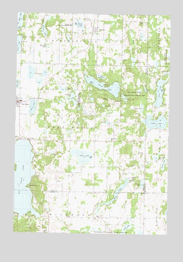
Burtrum, MN USGS Topographic Map
Click on map above to begin viewing in our Map Viewer.

This topographic map contains these locations and features:
Feature Name Type Latitude Longitude GNIS ID View Map
August Glockzin Pond DamDamN45.8050°W94.7253°1776364View Map
August Glockzin ReservoirReservoirN45.8050°W94.7253°1776365View Map
Bass LakeLakeN45.8218°W94.7362°639676View Map
Big Birch LakeLakeN45.7788°W94.7495°640079View Map
Bony Dog LakeLakeN45.8564°W94.7254°640367View Map
Brighter Days Family ChurchChurchN45.8675°W94.6847°2068949View Map
Buck LakeLakeN45.8688°W94.6994°640581View Map
Buckhead LakeLakeN45.8266°W94.7038°640591View Map
Buckhead Lake State Wildlife Management AreaParkN45.8261°W94.6986°640592View Map
BurtrumPopulated PlaceN45.8675°W94.6850°640690View Map
Burtrum (historical)LocaleN45.8675°W94.6889°2068950View Map
Burtrum Post OfficePost OfficeN45.8675°W94.6847°2068947View Map
Cedar LakeLakeN45.8140°W94.6357°641013View Map
Cedar Lake Memorial ParkParkN45.8167°W94.6256°2068720View Map
City of BurtrumCivilN45.8659°W94.6874°2393476View Map
City of Grey EagleCivilN45.8243°W94.7492°2394249View Map
Coon LakeLakeN45.8516°W94.6252°641475View Map
Eagle MountainSummitN45.8266°W94.6795°643035View Map
Eagle Mountain Winter Recreation AreaLocaleN45.8278°W94.6750°2068893View Map
Faith Community ChurchChurchN45.8675°W94.6847°2068948View Map
Fish CreekStreamN45.7844°W94.7339°643666View Map
G A R CemeteryCemeteryN45.8722°W94.6958°643996View Map
Goose LakeLakeN45.7942°W94.6950°644252View Map
Grey EaglePopulated PlaceN45.8252°W94.7467°644480View Map
Grey Eagle City HallBuildingN45.8239°W94.7472°2068891View Map
Grey Eagle Community LibraryBuildingN45.8250°W94.7467°2068889View Map
Grey Eagle Elementary SchoolSchoolN45.8250°W94.7450°2068878View Map
Grey Eagle Fire DepartmentBuildingN45.8229°W94.7485°2068892View Map
Grey Eagle Medical ClinicHospitalN45.8247°W94.7478°2068888View Map
Grey Eagle Post OfficePost OfficeN45.8250°W94.7467°2068885View Map
Hill LakeLakeN45.8230°W94.6788°644970View Map
Horseshoe LakeLakeN45.7939°W94.6352°645218View Map
Ireland State Wildlife Management AreaParkN45.8666°W94.7036°645445View Map
Jim LakeLakeN45.8128°W94.6718°645649View Map
Lakeview CemeteryCemeteryN45.8033°W94.7497°646433View Map
Little Mound LakeLakeN45.8393°W94.6811°646862View Map
Lovell LakeLakeN45.7515°W94.6600°647236View Map
Mary LakeLakeN45.7727°W94.6675°647591View Map
Molly LakeLakeN45.8483°W94.6551°648021View Map
Mound LakeLakeN45.8344°W94.6802°648149View Map
Mount Olive Lutheran ChurchChurchN45.8253°W94.7464°2068887View Map
Mountain LakeLakeN45.8651°W94.7282°648193View Map
Nellies LakeLakeN45.8218°W94.6471°648446View Map
North ShorePopulated PlaceN45.8027°W94.7381°648691View Map
Oak Ridge State Wildlife Management AreaParkN45.8300°W94.6536°648859View Map
Old Saint Marys CemeteryCemeteryN45.8033°W94.6714°648933View Map
Pine LakeLakeN45.8309°W94.6328°649475View Map
Pleasant BeachPopulated PlaceN45.7780°W94.7353°649547View Map
Rock LakeLakeN45.8327°W94.6447°650194View Map
Saint John's Lutheran ChurchChurchN45.8236°W94.7492°2068884View Map
Saint Peters CemeteryCemeteryN45.8491°W94.6639°651022View Map
Schreiers LakeLakeN45.7788°W94.6459°651784View Map
Slough LakeLakeN45.8318°W94.7119°652160View Map
Sponsa State Wildlife Management AreaParkN45.8514°W94.6275°652410View Map
Stony LakeLakeN45.7904°W94.6288°652683View Map
Stump LakeLakeN45.8275°W94.6616°652742View Map
The MoundSummitN45.8341°W94.6761°653112View Map
Township of Grey EagleCivilN45.8096°W94.7050°664356View Map
Twin LakesLakeN45.8413°W94.7380°653439View Map
United Methodist ChurchChurchN45.8253°W94.7464°2068886View Map

Note: Coordinates in the location and feature list above are referenced to NAD83 datum.


Copyright (C) 2008-2024 Ryan Niemi / Sunset Dynamics ... All Rights Reserved