TopoQuest Logo
Do you find TopoQuest useful?
Help keep TopoQuest running and adding new maps/features by donating!
Bitcoin:  19c7KJd3qBynnjoSw5npx9KScwjBe4ifkT
Litecoin:  LXs6TkuXGGXo1vDsWCkWVdjQX94eUKd6ui
Home View Maps Find Maps Find Places Resources & Links


Burkett, Texas Topographic Map

USGS Map Title: Burkett, TX
USGS Map MRC: 31099H2
DRG (GeoTIFF) Download: o31099h2.tif


Neighboring USGS Topographic Map Quads:


  Webbville, TX  
32099A3
 

  Cross Cut, TX  
32099A2
 

  Pioneer, TX  
32099A1
 

  Coleman NE, TX  
31099H3
 

  Burkett, TX  
31099H2
 

  Byrds, TX  
31099H1
 

  Lake San Tana, TX  
31099G3
 

  Thrifty, TX  
31099G2
 

  Lake Brownwood, TX  
31099G1


Map MRC Location:

N32°
W100°
N32°
W99°
H8 H7 H6 H5 H4 H3 H2 H1
G8 G7 G6 G5 G4 G3 G2 G1
F8 F7 F6 F5 F4 F3 F2 F1
E8 E7 E6 E5 E4 E3 E2 E1
D8 D7 D6 D5 D4 D3 D2 D1
C8 C7 C6 C5 C4 C3 C2 C1
B8 B7 B6 B5 B4 B3 B2 B1
A8 A7 A6 A5 A4 A3 A2 A1
N31°
W100°
N31°
W99°

Burkett, TX USGS 1:24K Topographic Map Preview:
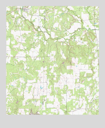
Burkett, TX USGS Topographic Map
Click on map above to begin viewing in our Map Viewer.

This topographic map contains these locations and features:
Feature Name Type Latitude Longitude GNIS ID View Map
Barefoot MountainsSummitN31.8935°W99.2073°1330039View Map
Bowden HollowValleyN31.9722°W99.1402°1331116View Map
BurkettPopulated PlaceN31.9960°W99.2256°1331677View Map
Burkett City DamDamN31.9968°W99.2287°1858669View Map
Burkett Post OfficePost OfficeN31.9955°W99.2266°2731356View Map
Cottonwood BranchStreamN31.9610°W99.1698°1333420View Map
Deadman BranchStreamN31.9840°W99.2231°1373360View Map
East Holloway CreekStreamN31.9960°W99.1428°1334951View Map
Gobbler BranchStreamN31.9599°W99.1962°1373864View Map
GrosvenorPopulated PlaceN31.8824°W99.1501°1378390View Map
Hay BranchStreamN31.9624°W99.1884°1337483View Map
Holloway MountainsSummitN31.9438°W99.1409°1337952View Map
Jolley LakeReservoirN31.9348°W99.1735°1864062View Map
Jolley Lake DamDamN31.9351°W99.1737°1864061View Map
McReynolds SpringSpringN31.8913°W99.1989°1341278View Map
Panther Creek CemeteryCemeteryN31.8896°W99.1373°1343537View Map
Pasture BranchStreamN31.9632°W99.1801°1343648View Map
Red KnobSummitN31.8885°W99.2214°1344931View Map
Smith CemeteryCemeteryN31.9676°W99.1567°1347255View Map
Soil Conservation Service Site 3 DamDamN31.8885°W99.2353°1858667View Map
Soil Conservation Service Site 3 ReservoirReservoirN31.8895°W99.2354°1858668View Map
Turkey CreekStreamN31.9749°W99.1462°1348870View Map
West Holloway CreekStreamN31.9957°W99.1428°1349749View Map

Note: Coordinates in the location and feature list above are referenced to NAD83 datum.


Copyright (C) 2008-2024 Ryan Niemi / Sunset Dynamics ... All Rights Reserved