TopoQuest Logo
Do you find TopoQuest useful?
Help keep TopoQuest running and adding new maps/features by donating!
Bitcoin:  19c7KJd3qBynnjoSw5npx9KScwjBe4ifkT
Litecoin:  LXs6TkuXGGXo1vDsWCkWVdjQX94eUKd6ui
Home View Maps Find Maps Find Places Resources & Links


Lake Brownwood, Texas Topographic Map

USGS Map Title: Lake Brownwood, TX
USGS Map MRC: 31099G1
DRG (GeoTIFF) Download: o31099g1.tif


Neighboring USGS Topographic Map Quads:


  Burkett, TX  
31099H2
 

  Byrds, TX  
31099H1
 

  May, TX  
31098H8
 

  Thrifty, TX  
31099G2
 

  Lake Brownwood, TX  
31099G1
 

  Owens, TX  
31098G8
 

  Bangs West, TX  
31099F2
 

  Bangs East, TX  
31099F1
 

  Brownwood, TX  
31098F8


Map MRC Location:

N32°
W100°
N32°
W99°
H8 H7 H6 H5 H4 H3 H2 H1
G8 G7 G6 G5 G4 G3 G2 G1
F8 F7 F6 F5 F4 F3 F2 F1
E8 E7 E6 E5 E4 E3 E2 E1
D8 D7 D6 D5 D4 D3 D2 D1
C8 C7 C6 C5 C4 C3 C2 C1
B8 B7 B6 B5 B4 B3 B2 B1
A8 A7 A6 A5 A4 A3 A2 A1
N31°
W100°
N31°
W99°

Lake Brownwood, TX USGS 1:24K Topographic Map Preview:
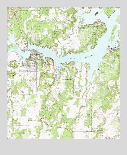
Lake Brownwood, TX USGS Topographic Map
Click on map above to begin viewing in our Map Viewer.

This topographic map contains these locations and features:
Feature Name Type Latitude Longitude GNIS ID View Map
Bangs DivisionCivilN31.8000°W99.1162°1938515View Map
Briar CreekStreamN31.8532°W99.1214°1331246View Map
Brownwood DamDamN31.8382°W99.0025°1331379View Map
Brownwood ReservoirReservoirN31.8385°W99.0020°1859750View Map
Cason CoveBayN31.8168°W99.0681°1332293View Map
Dry CreekStreamN31.8476°W99.1181°1334676View Map
Goat IslandIslandN31.8693°W99.0253°1336611View Map
Jim Ned BranchStreamN31.8013°W99.0339°1374295View Map
Jim Ned CreekStreamN31.8357°W99.1162°1374296View Map
Keesee CreekStreamN31.8379°W99.0631°1338983View Map
Lake BrownwoodReservoirN31.8722°W99.0221°1331387View Map
Lake BrownwoodPopulated PlaceN31.8357°W99.0078°1339486View Map
Lake Brownwood Census Designated PlaceCensusN31.8176°W99.1045°2408534View Map
Lake Brownwood State ParkParkN31.8557°W99.0234°1339487View Map
Lake Brownwood State Park TrailTrailN31.8571°W99.0206°2033486View Map
Lake Brownwood Volunteer Fire DepartmentBuildingN31.8324°W99.0966°2551043View Map
Lake Dam Volunteer Fire DepartmentBuildingN31.8379°W99.0113°2551045View Map
Lake ShorePopulated PlaceN31.8299°W99.0909°1339512View Map
Macedonia CemeteryCemeteryN31.8532°W99.0473°1340794View Map
McCartney IslandIslandN31.8504°W99.0084°1341149View Map
McDaniel CemeteryCemeteryN31.7563°W99.1098°1341179View Map
Panther CreekStreamN31.8518°W99.1189°1343533View Map
Rocky CreekStreamN31.8129°W99.0687°1375809View Map
Rocky Creek ChurchChurchN31.7696°W99.0845°1345472View Map
Rough CreekStreamN31.8196°W99.0812°1345634View Map
Shamrock ShoresPopulated PlaceN31.8204°W99.0992°1346968View Map
Short CreekStreamN31.8215°W99.1092°1347092View Map
Soil Conservation Service Site 8 DamDamN31.7768°W99.0037°1859751View Map
Soil Conservation Service Site 8 ReservoirReservoirN31.7770°W99.0049°1859752View Map
Turner CreekStreamN31.8432°W99.1020°1348911View Map

Note: Coordinates in the location and feature list above are referenced to NAD83 datum.


Copyright (C) 2008-2024 Ryan Niemi / Sunset Dynamics ... All Rights Reserved