TopoQuest Logo
Do you find TopoQuest useful?
Help keep TopoQuest running and adding new maps/features by donating!
Bitcoin:  19c7KJd3qBynnjoSw5npx9KScwjBe4ifkT
Litecoin:  LXs6TkuXGGXo1vDsWCkWVdjQX94eUKd6ui
Home View Maps Find Maps Find Places Resources & Links


Buena Vista, Mississippi Topographic Map

USGS Map Title: Buena Vista, MS
USGS Map MRC: 33088H7
DRG (GeoTIFF) Download: o33088h7.tif


Neighboring USGS Topographic Map Quads:


  Troy, MS  
34088A8
 

  Troy SE, MS  
34088A7
 

  Shannon, MS  
34088A6
 

  Houston East, MS  
33088H8
 

  Buena Vista, MS  
33088H7
 

  Egypt, MS  
33088H6
 

  Sparta, MS  
33088G8
 

  Trebloc, MS  
33088G7
 

  Prairie, MS  
33088G6


Map MRC Location:

N34°
W89°
N34°
W88°
H8 H7 H6 H5 H4 H3 H2 H1
G8 G7 G6 G5 G4 G3 G2 G1
F8 F7 F6 F5 F4 F3 F2 F1
E8 E7 E6 E5 E4 E3 E2 E1
D8 D7 D6 D5 D4 D3 D2 D1
C8 C7 C6 C5 C4 C3 C2 C1
B8 B7 B6 B5 B4 B3 B2 B1
A8 A7 A6 A5 A4 A3 A2 A1
N33°
W89°
N33°
W88°

Buena Vista, MS USGS 1:24K Topographic Map Preview:
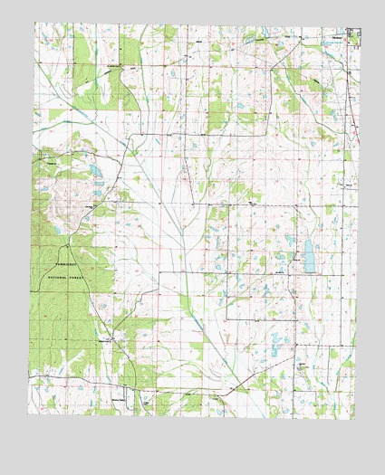
Buena Vista, MS USGS Topographic Map
Click on map above to begin viewing in our Map Viewer.

This topographic map contains these locations and features:
Feature Name Type Latitude Longitude GNIS ID View Map
Anderson Lake DamDamN33.9318°W88.8651°695505View Map
Bacon (historical)Populated PlaceN33.9854°W88.8403°705362View Map
Bell CreekStreamN33.8818°W88.7578°692534View Map
Boone ChurchChurchN33.9265°W88.7739°692673View Map
Buena VistaPopulated PlaceN33.8846°W88.8381°692754View Map
Buena Vista CemeteryCemeteryN33.8848°W88.8395°710255View Map
Buena Vista High School (historical)SchoolN33.8826°W88.8378°710256View Map
Buena Vista Landmark Baptist Church (historical)ChurchN33.8796°W88.8478°710257View Map
Buena Vista Presbyterian Church (historical)ChurchN33.8846°W88.8384°711471View Map
Buena Vista United Methodist ChurchChurchN33.8840°W88.8387°710260View Map
Cane CreekStreamN33.9584°W88.8356°692829View Map
Chalk Bluff (historical)Populated PlaceN33.9284°W88.7734°710264View Map
Chalk Bluff School (historical)SchoolN33.9282°W88.7903°705368View Map
Chuquatonchee Creek Structure 13 DamDamN33.9568°W88.8451°695510View Map
Chuquatonchee Creek Structure 17 DamDamN33.9218°W88.7667°695500View Map
Citizens CemeteryCemeteryN33.9989°W88.7547°2703719View Map
Clark School (historical)SchoolN33.9487°W88.7551°710271View Map
Clarks Chapel Baptist ChurchChurchN33.9496°W88.7551°692916View Map
Confederate CemeteryCemeteryN33.9988°W88.7536°2703659View Map
Dicks CreekStreamN33.9682°W88.8514°693090View Map
Egypt PrairieAreaN33.9001°W88.7834°710284View Map
Gregory Lake DamDamN33.9634°W88.8251°695511View Map
Holiness ChurchChurchN33.9179°W88.7987°693500View Map
JollyPopulated PlaceN33.9432°W88.7903°710320View Map
Jolly Lake DamDamN33.9934°W88.7867°695525View Map
Jollys Chapel Missionary Baptist ChurchChurchN33.9434°W88.7903°693631View Map
Jones (historical)LocaleN33.9968°W88.7723°710321View Map
Mount Moriah CemeteryCemeteryN33.9868°W88.8414°705380View Map
Mount Olive Baptist ChurchChurchN33.9218°W88.7814°694083View Map
New Hope ChurchChurchN33.9415°W88.8503°694175View Map
Newport (historical)Populated PlaceN33.9068°W88.7617°705386View Map
Palestine Missionary Baptist ChurchChurchN33.9551°W88.8689°694297View Map
Pikeville (historical)Populated PlaceN33.8951°W88.7737°705389View Map
Pleasant Grove Missionary Baptist ChurchChurchN33.8996°W88.8437°705390View Map
Pleasant Grove SchoolSchoolN33.9012°W88.8437°694428View Map
Pulliam CemeteryCemeteryN33.8796°W88.8306°694487View Map
Redbud Missionary Baptist ChurchChurchN33.8921°W88.7712°694524View Map
Redbud School (historical)SchoolN33.8918°W88.7706°710365View Map
Schwench Lake DamDamN33.9318°W88.7751°695504View Map
Shaw CreekStreamN33.9684°W88.8514°694755View Map
Snow CemeteryCemeteryN33.8909°W88.7706°705397View Map
Southeast Chickasaw Volunteer Fire DepartmentBuildingN33.8839°W88.8377°2666054View Map
Supervisor District 1CivilN33.8950°W88.8455°711798View Map
Union Baptist ChurchChurchN33.9648°W88.8156°695046View Map
Union School (historical)SchoolN33.9651°W88.8167°710384View Map

Note: Coordinates in the location and feature list above are referenced to NAD83 datum.


Copyright (C) 2008-2024 Ryan Niemi / Sunset Dynamics ... All Rights Reserved