TopoQuest Logo
Do you find TopoQuest useful?
Help keep TopoQuest running and adding new maps/features by donating!
Bitcoin:  19c7KJd3qBynnjoSw5npx9KScwjBe4ifkT
Litecoin:  LXs6TkuXGGXo1vDsWCkWVdjQX94eUKd6ui
Home View Maps Find Maps Find Places Resources & Links


Troy, Mississippi Topographic Map

USGS Map Title: Troy, MS
USGS Map MRC: 34088A8
DRG (GeoTIFF) Download: o34088a8.tif


Neighboring USGS Topographic Map Quads:


  Southwest Pontotoc, MS  
34089B1
 

  Southeast Pontotoc, MS  
34088B8
 

  Bissell, MS  
34088B7
 

  Houlka, MS  
34089A1
 

  Troy, MS  
34088A8
 

  Troy SE, MS  
34088A7
 

  Houston West, MS  
33089H1
 

  Houston East, MS  
33088H8
 

  Buena Vista, MS  
33088H7


Map MRC Location:

N35°
W89°
N35°
W88°
H8 H7 H6 H5 H4 H3 H2 H1
G8 G7 G6 G5 G4 G3 G2 G1
F8 F7 F6 F5 F4 F3 F2 F1
E8 E7 E6 E5 E4 E3 E2 E1
D8 D7 D6 D5 D4 D3 D2 D1
C8 C7 C6 C5 C4 C3 C2 C1
B8 B7 B6 B5 B4 B3 B2 B1
A8 A7 A6 A5 A4 A3 A2 A1
N34°
W89°
N34°
W88°

Troy, MS USGS 1:24K Topographic Map Preview:
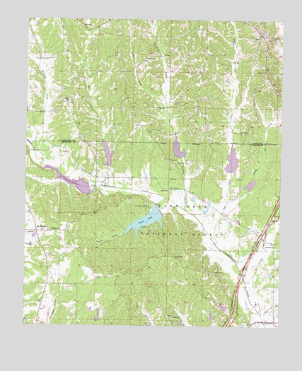
Troy, MS USGS Topographic Map
Click on map above to begin viewing in our Map Viewer.

This topographic map contains these locations and features:
Feature Name Type Latitude Longitude GNIS ID View Map
4 A-2020 DamDamN34.0551°W88.8934°695549View Map
4 A-2020 LakeReservoirN34.0551°W88.8934°695548View Map
Bluff Springs CemeteryCemeteryN34.0282°W88.9270°692652View Map
Camp BellewoodLocaleN34.0490°W88.9403°692810View Map
Center Hill Baptist ChurchChurchN34.0329°W88.8778°692868View Map
Chickasaw Game Management AreaParkN34.0334°W88.9417°705371View Map
Chuckafalyia (historical)LocaleN34.1057°W88.9834°706864View Map
Chuquatonchee Creek Structure 1 DamDamN34.0668°W88.9834°695553View Map
Chuquatonchee Creek Structure 10 DamDamN34.0134°W88.8801°695531View Map
Chuquatonchee Creek Structure 2 DamDamN34.0634°W88.9567°695551View Map
Chuquatonchee Creek Structure 3 DamDamN34.0651°W88.9217°695552View Map
Chuquatonchee Creek Structure 4 DamDamN34.0568°W88.9001°695550View Map
Chuquatonchee Creek Structure 4a DamDamN34.0518°W88.8967°695547View Map
Chuquatonchee Creek Structure 9 DamDamN34.0034°W88.9001°695528View Map
Coleville (historical)Populated PlaceN34.0376°W88.8862°705372View Map
Davis CreekStreamN34.0523°W88.9312°693062View Map
Davis LakeReservoirN34.0430°W88.9407°693066View Map
Davis Lake CampgroundLocaleN34.0473°W88.9389°705605View Map
Davis Lake DamDamN34.0451°W88.9351°695546View Map
Falkner CemeteryCemeteryN34.1034°W88.8837°693199View Map
Friendship ChurchChurchN34.0037°W88.9278°693271View Map
Friendship School (historical)SchoolN34.0032°W88.9281°710293View Map
GoodfordPopulated PlaceN34.1087°W88.9426°693325View Map
Goodford CreekStreamN34.0473°W88.9214°693324View Map
Halsey CemeteryCemeteryN34.0676°W88.9298°693400View Map
Hickory Flat (historical)Populated PlaceN34.0184°W88.8770°705375View Map
Little CreekStreamN34.0879°W88.9320°672589View Map
Little Owl CreekStreamN34.0507°W88.9014°693775View Map
Macedonia ChurchChurchN34.0390°W88.9831°693861View Map
Mill CreekStreamN34.0562°W88.9559°693999View Map
Monroe Missionary Station (historical)LocaleN34.0979°W88.9951°704915View Map
Natchez Trace National Scenic TrailTrailN34.0109°W88.8964°163110View Map
New Salem (historical)LocaleN34.0782°W88.8931°706894View Map
New Salem ChurchChurchN34.0793°W88.8953°694187View Map
New Salem School (historical)SchoolN34.0793°W88.8956°706895View Map
Oak Grove School (historical)SchoolN34.0384°W88.9842°710340View Map
Old HoulkaPopulated PlaceN34.0382°W88.9942°694262View Map
Owl CreekStreamN34.0337°W88.9067°694291View Map
Pilgrim ChurchChurchN34.0601°W88.9295°694367View Map
Pontotoc RidgeRidgeN34.1084°W88.9834°706912View Map
Primitive Baptist Church of Bethel (historical)ChurchN34.0923°W88.9789°706915View Map
Red Land (historical)LocaleN34.0987°W88.9764°706918View Map
Redland CemeteryCemeteryN34.0920°W88.9795°694542View Map
Redland CreekStreamN34.0712°W88.9964°694543View Map
Ridgeway School (historical)SchoolN34.0173°W88.9559°705392View Map
Rose Hill CemeteryCemeteryN34.0323°W88.9962°694609View Map
Sand BranchStreamN34.0023°W88.8828°694688View Map
Sharby CreekStreamN34.0184°W88.8917°694751View Map
Shiloh Baptist ChurchChurchN34.0554°W88.9306°694767View Map
Shiloh School (historical)SchoolN34.0557°W88.9309°710376View Map
Tockshish Mission (historical)ChurchN34.1223°W88.9726°706940View Map
Toxish ChurchChurchN34.1223°W88.9723°695001View Map
TroyPopulated PlaceN34.1190°W88.8851°695008View Map
Troy Baptist ChurchChurchN34.1168°W88.8853°706941View Map
Troy Woodland Volunteer Fire DepartmentBuildingN34.1165°W88.8861°2665899View Map

Note: Coordinates in the location and feature list above are referenced to NAD83 datum.


Copyright (C) 2008-2024 Ryan Niemi / Sunset Dynamics ... All Rights Reserved