TopoQuest Logo
Do you find TopoQuest useful?
Help keep TopoQuest running and adding new maps/features by donating!
Bitcoin:  19c7KJd3qBynnjoSw5npx9KScwjBe4ifkT
Litecoin:  LXs6TkuXGGXo1vDsWCkWVdjQX94eUKd6ui
Home View Maps Find Maps Find Places Resources & Links


Brownsville, Oregon Topographic Map

USGS Map Title: Brownsville, OR
USGS Map MRC: 44122D8
DRG (GeoTIFF) Download: o44122d8.tif


Neighboring USGS Topographic Map Quads:


  Tangent, OR  
44123E1
 

  Lebanon, OR  
44122E8
 

  Onehorse Slough, OR  
44122E7
 

  Halsey, OR  
44123D1
 

  Brownsville, OR  
44122D8
 

  Waterloo, OR  
44122D7
 

  Indian Head, OR  
44123C1
 

  Union Point, OR  
44122C8
 

  Crawfordsville, OR  
44122C7


Map MRC Location:

N45°
W123°
N45°
W122°
H8 H7 H6 H5 H4 H3 H2 H1
G8 G7 G6 G5 G4 G3 G2 G1
F8 F7 F6 F5 F4 F3 F2 F1
E8 E7 E6 E5 E4 E3 E2 E1
D8 D7 D6 D5 D4 D3 D2 D1
C8 C7 C6 C5 C4 C3 C2 C1
B8 B7 B6 B5 B4 B3 B2 B1
A8 A7 A6 A5 A4 A3 A2 A1
N44°
W123°
N44°
W122°

Brownsville, OR USGS 1:24K Topographic Map Preview:
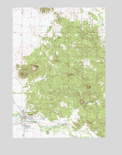
Brownsville, OR USGS Topographic Map
Click on map above to begin viewing in our Map Viewer.

This topographic map contains these locations and features:
Feature Name Type Latitude Longitude GNIS ID View Map
BrownsvillePopulated PlaceN44.3935°W122.9848°1118140View Map
Brownsville City HallBuildingN44.3932°W122.9847°2699162View Map
Brownsville Community LibraryBuildingN44.3940°W122.9833°2699163View Map
Brownsville DamDamN44.3873°W122.9318°1130624View Map
Brownsville DitchCanalN44.3907°W122.9504°1118141View Map
Brownsville Mennonite ChurchChurchN44.3903°W122.9958°2508173View Map
Brownsville Municipal CourtBuildingN44.3932°W122.9847°2699164View Map
Brownsville Pioneer CemeteryCemeteryN44.3949°W122.9589°1130625View Map
Brownsville Post OfficePost OfficeN44.3948°W122.9842°1164974View Map
Brownsville Public Works Department OfficeBuildingN44.3874°W122.9780°2699165View Map
Brownsville Rural Fire District 61BuildingN44.3931°W122.9847°2576557View Map
Brownsville Sewage Treatment FacilityLocaleN44.4088°W122.9999°2697145View Map
Cedar ButteSummitN44.4235°W122.9015°1118717View Map
City of BrownsvilleCivilN44.3923°W122.9834°2409923View Map
Claypool CemeteryCemeteryN44.4612°W122.9595°1130627View Map
Dodge CemeteryCemeteryN44.4938°W122.9431°1119990View Map
Farm Service Agency Interest of OregonParkN44.4942°W122.8810°2765295View Map
Kearns ReservoirReservoirN44.4605°W122.9763°1130626View Map
Lone Pine ButteSummitN44.4418°W122.9718°1136495View Map
Robe HillSummitN44.4187°W122.9120°1136692View Map
Rock HillLocaleN44.4829°W122.9493°1136697View Map
Rock HillSummitN44.4804°W122.9498°1160561View Map
Schneider Log PondReservoirN44.3919°W122.9977°1130302View Map
Snake HillSummitN44.4107°W122.9093°1136762View Map
Warren CreekStreamN44.3885°W122.9331°1128671View Map
Washburn ButteSummitN44.4362°W122.9862°1128690View Map

Note: Coordinates in the location and feature list above are referenced to NAD83 datum.


Copyright (C) 2008-2024 Ryan Niemi / Sunset Dynamics ... All Rights Reserved