TopoQuest Logo
Do you find TopoQuest useful?
Help keep TopoQuest running and adding new maps/features by donating!
Bitcoin:  19c7KJd3qBynnjoSw5npx9KScwjBe4ifkT
Litecoin:  LXs6TkuXGGXo1vDsWCkWVdjQX94eUKd6ui
Home View Maps Find Maps Find Places Resources & Links


Breckenridge, Missouri Topographic Map

USGS Map Title: Breckenridge, MO
USGS Map MRC: 39093G7
DRG (GeoTIFF) Download: o39093g7.tif


Neighboring USGS Topographic Map Quads:


  Gallatin, MO  
39093H8
 

  Jamesport, MO  
39093H7
 

  Shearwood, MO  
39093H6
 

  Nettleton, MO  
39093G8
 

  Breckenridge, MO  
39093G7
 

  Sampsel, MO  
39093G6
 

  Hamilton East, MO  
39093F8
 

  Flat Creek, MO  
39093F7
 

  Utica West, MO  
39093F6


Map MRC Location:

N40°
W94°
N40°
W93°
H8 H7 H6 H5 H4 H3 H2 H1
G8 G7 G6 G5 G4 G3 G2 G1
F8 F7 F6 F5 F4 F3 F2 F1
E8 E7 E6 E5 E4 E3 E2 E1
D8 D7 D6 D5 D4 D3 D2 D1
C8 C7 C6 C5 C4 C3 C2 C1
B8 B7 B6 B5 B4 B3 B2 B1
A8 A7 A6 A5 A4 A3 A2 A1
N39°
W94°
N39°
W93°

Breckenridge, MO USGS 1:24K Topographic Map Preview:
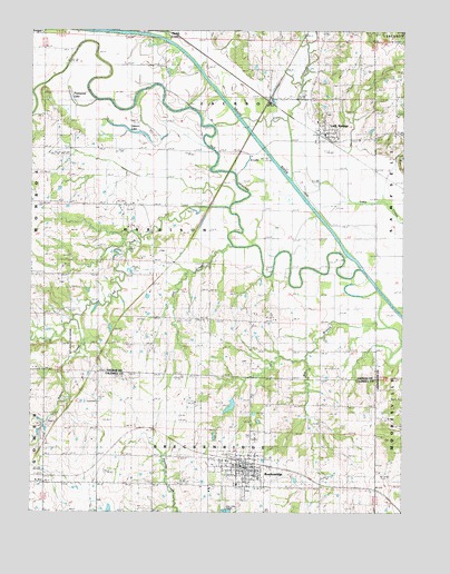
Breckenridge, MO USGS Topographic Map
Click on map above to begin viewing in our Map Viewer.

This topographic map contains these locations and features:
Feature Name Type Latitude Longitude GNIS ID View Map
Big BranchStreamN39.7983°W93.7524°714140View Map
BreckenridgePopulated PlaceN39.7622°W93.8044°714664View Map
Breckenridge Elementary SchoolSchoolN39.7572°W93.8055°2545307View Map
Breckenridge Fire DepartmentBuildingN39.7622°W93.8032°2621592View Map
Breckenridge High SchoolSchoolN39.7570°W93.8057°2545375View Map
Breckenridge Post OfficePost OfficeN39.7613°W93.8028°2782572View Map
Breckenridge ReservoirReservoirN39.7777°W93.8078°761252View Map
Breckenridge Volunteer Fire DepartmentBuildingN39.7622°W93.8031°2621711View Map
City of BreckenridgeCivilN39.7614°W93.8046°2393406View Map
City of Breckenridge DamDamN39.7800°W93.8069°761251View Map
Clear CreekStreamN39.8506°W93.8149°715937View Map
Elm Grove School (historical)SchoolN39.7658°W93.7783°717520View Map
Hale School (historical)SchoolN39.8131°W93.8544°718994View Map
Highland ChurchChurchN39.7811°W93.7585°719569View Map
Kettle CreekStreamN39.7997°W93.8611°720558View Map
Lick ForkStreamN39.8322°W93.8080°721038View Map
Lock SpringsPopulated PlaceN39.8489°W93.7774°741020View Map
Lock Springs Fire Protection DistrictBuildingN39.8482°W93.7765°2621086View Map
Mann SchoolSchoolN39.8447°W93.8538°721801View Map
Muddy CreekStreamN39.8725°W93.8289°723038View Map
Osborn LakeLakeN39.8485°W93.8406°723865View Map
Owl CreekStreamN39.8191°W93.8073°723921View Map
Packwood LakeLakeN39.8589°W93.8622°723954View Map
Railroad SchoolSchoolN39.7653°W93.8538°725075View Map
Reed School (historical)SchoolN39.7981°W93.8149°725190View Map
Rose Hill CemeteryCemeteryN39.7551°W93.8033°2681376View Map
South LakeLakeN39.8433°W93.8055°726765View Map
Township of HarrisonCivilN39.8170°W93.8275°766579View Map
Trotter SchoolSchoolN39.7936°W93.7822°727807View Map
Village of Lock SpringsCivilN39.8488°W93.7762°2398461View Map

Note: Coordinates in the location and feature list above are referenced to NAD83 datum.


Copyright (C) 2008-2024 Ryan Niemi / Sunset Dynamics ... All Rights Reserved