TopoQuest Logo
Do you find TopoQuest useful?
Help keep TopoQuest running and adding new maps/features by donating!
Bitcoin:  19c7KJd3qBynnjoSw5npx9KScwjBe4ifkT
Litecoin:  LXs6TkuXGGXo1vDsWCkWVdjQX94eUKd6ui
Home View Maps Find Maps Find Places Resources & Links


Jamesport, Missouri Topographic Map

USGS Map Title: Jamesport, MO
USGS Map MRC: 39093H7
DRG (GeoTIFF) Download: o39093h7.tif


Neighboring USGS Topographic Map Quads:


  Jameson, MO  
40093A8
 

  Bancroft, MO  
40093A7
 

  Trenton West, MO  
40093A6
 

  Gallatin, MO  
39093H8
 

  Jamesport, MO  
39093H7
 

  Shearwood, MO  
39093H6
 

  Nettleton, MO  
39093G8
 

  Breckenridge, MO  
39093G7
 

  Sampsel, MO  
39093G6


Map MRC Location:

N40°
W94°
N40°
W93°
H8 H7 H6 H5 H4 H3 H2 H1
G8 G7 G6 G5 G4 G3 G2 G1
F8 F7 F6 F5 F4 F3 F2 F1
E8 E7 E6 E5 E4 E3 E2 E1
D8 D7 D6 D5 D4 D3 D2 D1
C8 C7 C6 C5 C4 C3 C2 C1
B8 B7 B6 B5 B4 B3 B2 B1
A8 A7 A6 A5 A4 A3 A2 A1
N39°
W94°
N39°
W93°

Jamesport, MO USGS 1:24K Topographic Map Preview:
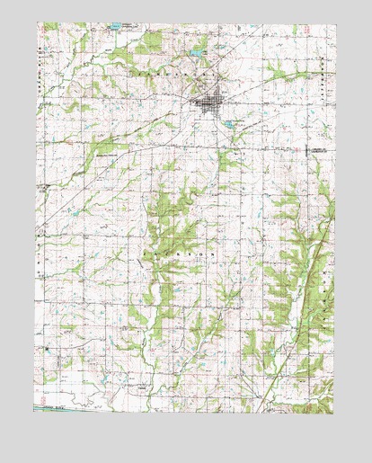
Jamesport, MO USGS Topographic Map
Click on map above to begin viewing in our Map Viewer.

This topographic map contains these locations and features:
Feature Name Type Latitude Longitude GNIS ID View Map
Arnold School (historical)SchoolN39.9758°W93.7808°713397View Map
BlakePopulated PlaceN39.9470°W93.8711°740680View Map
Blake School (historical)SchoolN39.9458°W93.8672°747013View Map
Brown School (historical)SchoolN39.9392°W93.7805°714787View Map
CarlowPopulated PlaceN39.8808°W93.8324°730067View Map
City LakeReservoirN39.9906°W93.8084°761103View Map
City of JamesportCivilN39.9750°W93.8029°2395453View Map
Clear Creek ChurchChurchN39.8861°W93.7891°715944View Map
Clear Creek SchoolSchoolN39.8939°W93.7799°715946View Map
East Brushy CreekStreamN39.9808°W93.8638°717262View Map
Froman Lake DamDamN39.9150°W93.8169°762708View Map
Hurricane BranchStreamN39.8808°W93.8261°720032View Map
JamesportPopulated PlaceN39.9747°W93.8011°720254View Map
Jamesport City DamDamN39.9905°W93.8112°761102View Map
Jamesport Community LakeReservoirN39.9996°W93.8424°761282View Map
Jamesport Lake DamDamN39.9983°W93.8419°761281View Map
Jamesport Memorial CemeteryCemeteryN39.9799°W93.8067°2681506View Map
Jamesport Post OfficePost OfficeN39.9749°W93.8009°2782677View Map
Jamesport Volunteer Fire DepartmentBuildingN39.9754°W93.8015°2621682View Map
Landmark Manufacturing Corporation AirportAirportN39.8942°W93.8648°758691View Map
McClung SchoolSchoolN39.9764°W93.8516°722047View Map
Miller School (historical)SchoolN39.9392°W93.8074°747014View Map
Mount Olive ChurchChurchN39.9089°W93.8463°722823View Map
Mount Zion Church (historical)ChurchN39.9317°W93.8077°722967View Map
Prairie Valley Church (historical)ChurchN39.9311°W93.8538°724887View Map
Spillman FieldAirportN39.9965°W93.7895°758734View Map
Township of JacksonCivilN39.8973°W93.8104°766580View Map
Tri - County Elementary SchoolSchoolN39.9747°W93.8095°2545302View Map
Tri - County High SchoolSchoolN39.9747°W93.8100°2545293View Map
West Brushy CreekStreamN39.9811°W93.8636°728539View Map

Note: Coordinates in the location and feature list above are referenced to NAD83 datum.


Copyright (C) 2008-2024 Ryan Niemi / Sunset Dynamics ... All Rights Reserved