TopoQuest Logo
Do you find TopoQuest useful?
Help keep TopoQuest running and adding new maps/features by donating!
Bitcoin:  19c7KJd3qBynnjoSw5npx9KScwjBe4ifkT
Litecoin:  LXs6TkuXGGXo1vDsWCkWVdjQX94eUKd6ui
Home View Maps Find Maps Find Places Resources & Links


Boydsville, Arkansas Topographic Map

USGS Map Title: Boydsville, AR
USGS Map MRC: 36090C4
DRG (GeoTIFF) Download: o36090c4.tif


Neighboring USGS Topographic Map Quads:


  Corning, AR  
36090D5
 

  McDougal, AR  
36090D4
 

  Pollard, AR  
36090D3
 

  Knobel, AR  
36090C5
 

  Boydsville, AR  
36090C4
 

  Rector, AR  
36090C3
 

  Lafe, AR  
36090B5
 

  Marmaduke, AR  
36090B4
 

  Mounds, AR  
36090B3


Map MRC Location:

N37°
W91°
N37°
W90°
H8 H7 H6 H5 H4 H3 H2 H1
G8 G7 G6 G5 G4 G3 G2 G1
F8 F7 F6 F5 F4 F3 F2 F1
E8 E7 E6 E5 E4 E3 E2 E1
D8 D7 D6 D5 D4 D3 D2 D1
C8 C7 C6 C5 C4 C3 C2 C1
B8 B7 B6 B5 B4 B3 B2 B1
A8 A7 A6 A5 A4 A3 A2 A1
N36°
W91°
N36°
W90°

Boydsville, AR USGS 1:24K Topographic Map Preview:
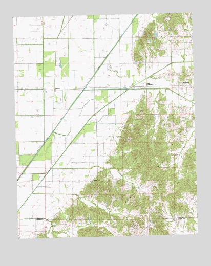
Boydsville, AR USGS Topographic Map
Click on map above to begin viewing in our Map Viewer.

This topographic map contains these locations and features:
Feature Name Type Latitude Longitude GNIS ID View Map
Bethlehem CemeteryCemeteryN36.2873°W90.4395°82604View Map
Bethlehem ChurchChurchN36.2870°W90.4398°46483View Map
BoydsvillePopulated PlaceN36.3342°W90.3837°57423View Map
Boydsville ChurchChurchN36.3351°W90.4101°46878View Map
Clay CountyCivilN36.3684°W90.4174°63759View Map
Ditch Number 10CanalN36.3248°W90.4368°82040View Map
Ditch Number 20CanalN36.3542°W90.4793°82153View Map
Ditch Number 25CanalN36.3598°W90.4921°82181View Map
Ditch Number 26CanalN36.3345°W90.4834°82186View Map
Ditch Number 27CanalN36.3201°W90.4926°82190View Map
Ditch Number 28CanalN36.3051°W90.4973°82193View Map
Dort CreekStreamN36.2740°W90.4609°48571View Map
Frie LakeReservoirN36.3684°W90.3801°80081View Map
Frie Lake DamDamN36.3684°W90.3801°80080View Map
Johnson CreekStreamN36.2884°W90.4526°50693View Map
KnobPopulated PlaceN36.2815°W90.4482°62506View Map
Knob School (historical)SchoolN36.2820°W90.4507°50900View Map
Lower BoydsvillePopulated PlaceN36.3340°W90.4084°62507View Map
North Big CreekStreamN36.3331°W90.4232°52805View Map
Purcel CemeteryCemeteryN36.2603°W90.3912°82659View Map
Purcel ChurchChurchN36.2601°W90.3923°53850View Map
Rock Springs CemeteryCemeteryN36.2787°W90.4440°82661View Map
Rock Springs ChurchChurchN36.2776°W90.4445°54114View Map
Salem CemeteryCemeteryN36.3209°W90.3820°82663View Map
Salem ChurchChurchN36.3223°W90.3820°54502View Map
Smith ChapelChurchN36.3590°W90.3893°54941View Map
TipperaryPopulated PlaceN36.3342°W90.4726°58748View Map
Township of JohnsonCivilN36.3229°W90.3907°63721View Map
Township of KnobCivilN36.2854°W90.4361°63723View Map
Turtle Knob School (historical)SchoolN36.3476°W90.4082°82669View Map

Note: Coordinates in the location and feature list above are referenced to NAD83 datum.


Copyright (C) 2008-2024 Ryan Niemi / Sunset Dynamics ... All Rights Reserved