TopoQuest Logo
Do you find TopoQuest useful?
Help keep TopoQuest running and adding new maps/features by donating!
Bitcoin:  19c7KJd3qBynnjoSw5npx9KScwjBe4ifkT
Litecoin:  LXs6TkuXGGXo1vDsWCkWVdjQX94eUKd6ui
Home View Maps Find Maps Find Places Resources & Links


Young, Arizona Topographic Map

USGS Map Title: Young, AZ
USGS Map MRC: 34110A8
DRG (GeoTIFF) Download: o34110a8.tif


Neighboring USGS Topographic Map Quads:


  Diamond Butte, AZ  
34111B1
 

  Oxbow Mountain, AZ  
34110B8
 

  Parallel Canyon, AZ  
34110B7
 

  Buzzard Roost Mesa, AZ  
34111A1
 

  Young, AZ  
34110A8
 

  Gentry Mountain, AZ  
34110A7
 

  Copper Mountain, AZ  
33111H1
 

  McFadden Peak, AZ  
33110H8
 

  Rock House, AZ  
33110H7


Map MRC Location:

N35°
W111°
N35°
W110°
H8 H7 H6 H5 H4 H3 H2 H1
G8 G7 G6 G5 G4 G3 G2 G1
F8 F7 F6 F5 F4 F3 F2 F1
E8 E7 E6 E5 E4 E3 E2 E1
D8 D7 D6 D5 D4 D3 D2 D1
C8 C7 C6 C5 C4 C3 C2 C1
B8 B7 B6 B5 B4 B3 B2 B1
A8 A7 A6 A5 A4 A3 A2 A1
N34°
W111°
N34°
W110°

Young, AZ USGS 1:24K Topographic Map Preview:
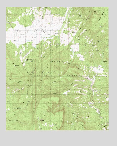
Young, AZ USGS Topographic Map
Click on map above to begin viewing in our Map Viewer.

This topographic map contains these locations and features:
Feature Name Type Latitude Longitude GNIS ID View Map
Big TankReservoirN34.0863°W110.9048°39259View Map
Box SpringSpringN34.0623°W110.9113°39284View Map
Bryant Ridge TankReservoirN34.0660°W110.9902°40659View Map
Buttes WellWellN34.1192°W110.9535°39309View Map
Calf TankReservoirN34.0334°W110.8793°39312View Map
Chapman Ranch AirstripAirportN34.0938°W110.9335°2650991View Map
Chapman Ranch AirstripAirportN34.0938°W110.9335°41085View Map
Cherry Creek SpringSpringN34.0400°W110.8951°40662View Map
Cherry Creek TankReservoirN34.0903°W110.9298°39341View Map
Cochran TankReservoirN34.1159°W110.9087°39363View Map
Creek SpringSpringN34.0414°W110.8929°39390View Map
Crouch CreekStreamN34.0498°W110.8954°28189View Map
Crouch MesaSummitN34.1098°W110.8890°28190View Map
Deadman CanyonValleyN34.0825°W110.9310°28332View Map
Divided SpringSpringN34.0805°W110.8909°39412View Map
Divided Water SpringSpringN34.0694°W110.8829°39413View Map
Double TankReservoirN34.1048°W110.8859°39418View Map
Fourmile CanyonValleyN34.0853°W110.9360°29150View Map
Graveyard CanyonValleyN34.0492°W110.9001°29556View Map
Gruwell WellWellN34.0875°W110.9960°39479View Map
Henry TankReservoirN34.0362°W110.9215°39501View Map
Hog CanyonValleyN34.0970°W110.9151°30016View Map
Hog Canyon TankReservoirN34.0988°W110.9162°39506View Map
Jerky TankReservoirN34.0403°W110.9865°40687View Map
Joe TankReservoirN34.0753°W110.9599°39548View Map
Juniper TankReservoirN34.0486°W110.9427°39553View Map
Lower Frio Canyon TankReservoirN34.0715°W110.9688°40707View Map
Lower Sparky TankReservoirN34.0703°W110.9743°39585View Map
Magnet TankReservoirN34.0900°W110.8863°39590View Map
McKenney SpringSpringN34.0674°W110.9232°39601View Map
McKinney TankReservoirN34.0856°W110.8943°39602View Map
Mexican CanyonValleyN34.1070°W110.9562°31779View Map
Mexican TankReservoirN34.1173°W110.9460°39615View Map
Natural TankReservoirN34.0672°W110.9019°39650View Map
Pleasant ValleyValleyN34.0939°W110.9365°33058View Map
Pleasant Valley Ranger DistrictForestN34.0309°W110.9629°2038814View Map
Pleasant Valley Ranger District OfficeLocaleN34.0984°W110.9421°33060View Map
Ridge TankReservoirN34.1012°W110.9045°39737View Map
Scarlet SpringSpringN34.0919°W110.9136°39778View Map
Snow TankReservoirN34.0586°W110.9499°39803View Map
Sparky SpringSpringN34.0320°W110.9732°39807View Map
Squaw MesaSummitN34.0100°W110.9576°34773View Map
Squaw PeakSummitN34.0103°W110.9576°34779View Map
Squaw TankReservoirN34.0084°W110.9429°39810View Map
Tunnel SpringSpringN34.0373°W110.8926°39848View Map
Turkey CreekStreamN34.0114°W110.8837°35538View Map
Upper Frio Canyon TankReservoirN34.0712°W110.9660°39856View Map
Upper TankReservoirN34.0775°W110.9827°39859View Map
Vosburg Trick TankReservoirN34.0556°W110.8793°39867View Map
Walnut CreekStreamN34.0006°W110.8790°35852View Map
YoungPopulated PlaceN34.1014°W110.9637°36483View Map
Young Census Designated PlaceCensusN34.1189°W110.9559°2409639View Map
Young Elementary SchoolSchoolN34.1001°W110.9655°33061View Map
Young Post OfficePost OfficeN34.1060°W110.9326°2783320View Map
Young Teaching High SchoolSchoolN34.1007°W110.9654°2545007View Map

Note: Coordinates in the location and feature list above are referenced to NAD83 datum.


Copyright (C) 2008-2024 Ryan Niemi / Sunset Dynamics ... All Rights Reserved