TopoQuest Logo
Do you find TopoQuest useful?
Help keep TopoQuest running and adding new maps/features by donating!
Bitcoin:  19c7KJd3qBynnjoSw5npx9KScwjBe4ifkT
Litecoin:  LXs6TkuXGGXo1vDsWCkWVdjQX94eUKd6ui
Home View Maps Find Maps Find Places Resources & Links


Yankeetown, Indiana Topographic Map

USGS Map Title: Yankeetown, IN
USGS Map MRC: 37087H3
DRG (GeoTIFF) Download: o37087h3.tif


Neighboring USGS Topographic Map Quads:


  Daylight, IN  
38087A4
 

  Boonville, IN  
38087A3
 

  De Gonia Springs, IN  
38087A2
 

  Newburgh, IN  
37087H4
 

  Yankeetown, IN  
37087H3
 

  Richland City, IN  
37087H2
 

  Spottsville, KY  
37087G4
 

  Reed, KY  
37087G3
 

  Owensboro West, KY  
37087G2


Map MRC Location:

N38°
W88°
N38°
W87°
H8 H7 H6 H5 H4 H3 H2 H1
G8 G7 G6 G5 G4 G3 G2 G1
F8 F7 F6 F5 F4 F3 F2 F1
E8 E7 E6 E5 E4 E3 E2 E1
D8 D7 D6 D5 D4 D3 D2 D1
C8 C7 C6 C5 C4 C3 C2 C1
B8 B7 B6 B5 B4 B3 B2 B1
A8 A7 A6 A5 A4 A3 A2 A1
N37°
W88°
N37°
W87°

Yankeetown, IN USGS 1:24K Topographic Map Preview:
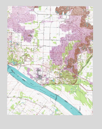
Yankeetown, IN USGS Topographic Map
Click on map above to begin viewing in our Map Viewer.

This topographic map contains these locations and features:
Feature Name Type Latitude Longitude GNIS ID View Map
Aluminum Company of America Fire Department and Emergency Medical ServicesBuildingN37.9272°W87.3277°2626161View Map
Baker CreekStreamN37.9148°W87.2675°430426View Map
Bates Hill CemeteryCemeteryN37.9248°W87.3125°430571View Map
Bethany ChurchChurchN37.9600°W87.2689°430866View Map
CarlinburgPopulated PlaceN37.8834°W87.3233°507654View Map
Chase LakeReservoirN37.9566°W87.3609°432434View Map
Clear CreekStreamN37.9042°W87.2703°432607View Map
Collins LakeReservoirN37.9147°W87.3073°432803View Map
Cornell AirportAirportN37.9823°W87.2943°2676965View Map
Cypress CreekStreamN37.9328°W87.3720°433274View Map
DayvillePopulated PlaceN37.9542°W87.3222°433371View Map
Friendship ChurchChurchN37.9884°W87.3122°434861View Map
Griffith Slough DitchCanalN37.8959°W87.3695°493392View Map
Hedge CemeteryCemeteryN37.9681°W87.2614°435973View Map
Horsman DitchCanalN37.8948°W87.3113°494618View Map
Kaiser DitchCanalN37.9612°W87.3111°437152View Map
Koehler DitchCanalN37.9539°W87.3167°437418View Map
Laketown (historical)Populated PlaceN37.8773°W87.3002°2742937View Map
McCool DitchCanalN37.9867°W87.3075°438810View Map
Mitchem DitchCanalN37.9942°W87.3336°439298View Map
PelzerPopulated PlaceN37.9892°W87.2572°440986View Map
Pleasant ChapelChurchN37.9814°W87.2578°441236View Map
PyeattvillePopulated PlaceN37.9420°W87.2519°447931View Map
Red BushPopulated PlaceN37.9384°W87.2719°441819View Map
Robert Richard DrainStreamN37.9106°W87.2556°442147View Map
Rustic HillsPopulated PlaceN37.9556°W87.3675°442423View Map
Saint Ruperts ChurchChurchN37.9392°W87.2719°442836View Map
ScuffletownPopulated PlaceN37.9228°W87.3722°509024View Map
Sharon ChurchChurchN37.9553°W87.3683°443297View Map
Summer Pecka DitchCanalN37.9700°W87.3625°451531View Map
Taylor DitchCanalN37.9684°W87.3058°444593View Map
Township of AndersonCivilN37.9304°W87.3007°453090View Map
U S Dam Number FourDamN37.9280°W87.3738°446759View Map
Union ChurchChurchN37.9912°W87.3597°445098View Map
VanadaPopulated PlaceN37.9323°W87.3645°445220View Map
Vanada CemeteryCemeteryN37.8992°W87.3281°505962View Map
Vanada LandingLocaleN37.9200°W87.3667°507331View Map
YankeetownPopulated PlaceN37.9175°W87.2978°446363View Map
Yankeetown Elementary SchoolSchoolN37.9256°W87.2953°446365View Map
Yankeetown Volunteer Fire DepartmentBuildingN37.9179°W87.2978°2625618View Map

Note: Coordinates in the location and feature list above are referenced to NAD83 datum.


Copyright (C) 2008-2024 Ryan Niemi / Sunset Dynamics ... All Rights Reserved