TopoQuest Logo
Do you find TopoQuest useful?
Help keep TopoQuest running and adding new maps/features by donating!
Bitcoin:  19c7KJd3qBynnjoSw5npx9KScwjBe4ifkT
Litecoin:  LXs6TkuXGGXo1vDsWCkWVdjQX94eUKd6ui
Home View Maps Find Maps Find Places Resources & Links


Newburgh, Indiana Topographic Map

USGS Map Title: Newburgh, IN
USGS Map MRC: 37087H4
DRG (GeoTIFF) Download: o37087h4.tif


Neighboring USGS Topographic Map Quads:


  Evansville North, IN  
38087A5
 

  Daylight, IN  
38087A4
 

  Boonville, IN  
38087A3
 

  Evansville South, IN  
37087H5
 

  Newburgh, IN  
37087H4
 

  Yankeetown, IN  
37087H3
 

  Henderson, KY  
37087G5
 

  Spottsville, KY  
37087G4
 

  Reed, KY  
37087G3


Map MRC Location:

N38°
W88°
N38°
W87°
H8 H7 H6 H5 H4 H3 H2 H1
G8 G7 G6 G5 G4 G3 G2 G1
F8 F7 F6 F5 F4 F3 F2 F1
E8 E7 E6 E5 E4 E3 E2 E1
D8 D7 D6 D5 D4 D3 D2 D1
C8 C7 C6 C5 C4 C3 C2 C1
B8 B7 B6 B5 B4 B3 B2 B1
A8 A7 A6 A5 A4 A3 A2 A1
N37°
W88°
N37°
W87°

Newburgh, IN USGS 1:24K Topographic Map Preview:
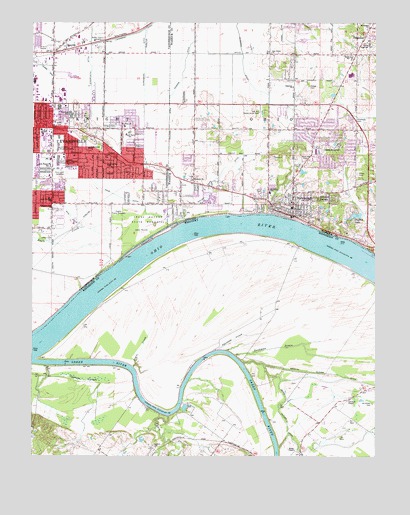
Newburgh, IN USGS Topographic Map
Click on map above to begin viewing in our Map Viewer.

This topographic map contains these locations and features:
Feature Name Type Latitude Longitude GNIS ID View Map
Akin DitchCanalN37.9439°W87.4856°430036View Map
Angel Mounds State MemorialParkN37.9425°W87.4592°430176View Map
Baskett CemeteryCemeteryN37.8784°W87.4561°486458View Map
Black Slough DitchCanalN37.8853°W87.4070°487387View Map
Brickwall CemeteryCemeteryN37.8903°W87.3758°487884View Map
Camp BrosendPopulated PlaceN37.9645°W87.3958°432012View Map
Casey CemeteryCemeteryN37.9567°W87.3819°432211View Map
Castle High SchoolSchoolN37.9937°W87.3775°432227View Map
Caze Elementary and Junior High SchoolSchoolN37.9487°W87.4936°447544View Map
Cypress SloughStreamN37.9012°W87.4942°490532View Map
Deaconess Cross PointeHospitalN37.9788°W87.4659°2660537View Map
Deaconess Gateway HospitalHospitalN37.9746°W87.4451°2660528View Map
Deadman DrainStreamN37.9039°W87.4258°490732View Map
Eagles Picnic GroundsParkN37.9442°W87.4695°433856View Map
Edwards DitchCanalN37.9928°W87.4245°434030View Map
Evansville Fire Department Station 6BuildingN37.9618°W87.4724°2626548View Map
Evansville Fire Department Station 9BuildingN37.9928°W87.4890°2626545View Map
Evansville Police Department East SectorBuildingN37.9720°W87.4915°2758184View Map
Gateway ChurchChurchN37.9817°W87.4053°434996View Map
Green RiverStreamN37.9025°W87.4997°493284View Map
Green River PlazaLocaleN37.9559°W87.4936°449078View Map
Habron Elementary and Junior High SchoolSchoolN37.9698°W87.4967°447545View Map
Harper DitchCanalN37.9881°W87.4986°435766View Map
Harrison SchoolSchoolN37.9739°W87.4861°435798View Map
Harrison Village MallLocaleN37.9756°W87.4939°449077View Map
Hebron SchoolSchoolN37.9692°W87.4967°435968View Map
Hedge CemeteryCemeteryN37.9817°W87.3992°435974View Map
Hillcrest TerracePopulated PlaceN37.9489°W87.3964°436209View Map
Holy Rosary SchoolSchoolN37.9589°W87.4936°436356View Map
Holy Rosary SchoolSchoolN37.9587°W87.4945°447546View Map
James CemeteryCemeteryN37.9373°W87.4936°436917View Map
John H Castle Elementary SchoolSchoolN37.9900°W87.3839°432230View Map
Knight Township Fire Department Company 7 (historical)BuildingN37.9473°W87.4676°2626608View Map
Kolb DitchCanalN37.9495°W87.4672°437431View Map
Lawndale Shopping CenterLocaleN37.9642°W87.4906°452354View Map
Lockwood DitchCanalN37.9967°W87.4628°438204View Map
Negro CreekStreamN37.9006°W87.4631°499235View Map
NewburghPopulated PlaceN37.9445°W87.4053°452469View Map
Newburgh Elementary SchoolSchoolN37.9467°W87.4056°447540View Map
Newburgh Town Police DepartmentBuildingN37.9493°W87.4049°2758264View Map
Newburgh Volunteer Fire DepartmentBuildingN37.9494°W87.4054°2625580View Map
Nurenbern DitchCanalN37.9884°W87.4595°440371View Map
Oak Grove ChurchChurchN37.9914°W87.4133°440415View Map
Oak Hill Conservation ClubLocaleN37.9748°W87.4186°452374View Map
Oakwood Chapel (historical)ChurchN37.8912°W87.3853°499758View Map
Ohio Township Fire and Rescue Station 1BuildingN37.9999°W87.3769°2625538View Map
Ohio Township Fire and Rescue Station 2BuildingN37.9728°W87.4419°2626135View Map
Opossum CreekStreamN37.9053°W87.4331°499961View Map
Our Savior ChurchChurchN37.9589°W87.4725°440774View Map
ParadisePopulated PlaceN37.9956°W87.3795°440858View Map
Park Lawn CemeteryCemeteryN37.9561°W87.4897°440875View Map
Pfafflin LakeReservoirN37.9446°W87.3821°452480View Map
Plaza Park Elementary and Junior High SchoolSchoolN37.9684°W87.4647°447521View Map
Plaza Park SchoolSchoolN37.9687°W87.4647°441231View Map
Pleasant View ChurchChurchN37.9464°W87.4925°451348View Map
Race CreekStreamN37.8867°W87.4503°501511View Map
Rose Hill CemeteryCemeteryN37.9611°W87.4006°442290View Map
Saint John the Baptist SchoolSchoolN37.9512°W87.4136°442607View Map
Saint Johns ChurchChurchN37.9700°W87.4664°442583View Map
Saint Michaels ChurchChurchN37.9639°W87.4792°442737View Map
Sloans ChapelChurchN37.8770°W87.4042°503702View Map
SmythePopulated PlaceN37.9914°W87.4925°443719View Map
South Willow Pond DitchCanalN37.9550°W87.4339°443870View Map
Stockfleith DitchCanalN37.9845°W87.4789°444181View Map
The Womans HospitalBuildingN37.9738°W87.4475°2660521View Map
Threemile IslandIslandN37.9387°W87.4531°505252View Map
Town of NewburghCivilN37.9494°W87.4052°2396812View Map
Townsend ChurchChurchN37.9989°W87.3767°444838View Map
Township of KnightCivilN37.9687°W87.4964°453528View Map
Township of OhioCivilN37.9946°W87.3920°453685View Map
Washington Square Shopping CenterLocaleN37.9606°W87.4906°445525View Map
Williams DitchCanalN37.9700°W87.4506°446076View Map
Women's HospitalHospitalN37.9737°W87.4476°2718863View Map

Note: Coordinates in the location and feature list above are referenced to NAD83 datum.


Copyright (C) 2008-2024 Ryan Niemi / Sunset Dynamics ... All Rights Reserved