TopoQuest Logo
Do you find TopoQuest useful?
Help keep TopoQuest running and adding new maps/features by donating!
Bitcoin:  19c7KJd3qBynnjoSw5npx9KScwjBe4ifkT
Litecoin:  LXs6TkuXGGXo1vDsWCkWVdjQX94eUKd6ui
Home View Maps Find Maps Find Places Resources & Links


Woodworth East, Louisiana Topographic Map

USGS Map Title: Woodworth East, LA
USGS Map MRC: 31092B4
DRG (GeoTIFF) Download: o31092b4.tif


Neighboring USGS Topographic Map Quads:


  Rapides, LA  
31092C5
 

  Alexandria, LA  
31092C4
 

  Libuse, LA  
31092C3
 

  Woodworth West, LA  
31092B5
 

  Woodworth East, LA  
31092B4
 

  Latanier, LA  
31092B3
 

  Forest Hill, LA  
31092A5
 

  Lecompte, LA  
31092A4
 

  Cheneyville, LA  
31092A3


Map MRC Location:

N32°
W93°
N32°
W92°
H8 H7 H6 H5 H4 H3 H2 H1
G8 G7 G6 G5 G4 G3 G2 G1
F8 F7 F6 F5 F4 F3 F2 F1
E8 E7 E6 E5 E4 E3 E2 E1
D8 D7 D6 D5 D4 D3 D2 D1
C8 C7 C6 C5 C4 C3 C2 C1
B8 B7 B6 B5 B4 B3 B2 B1
A8 A7 A6 A5 A4 A3 A2 A1
N31°
W93°
N31°
W92°

Woodworth East, LA USGS 1:24K Topographic Map Preview:
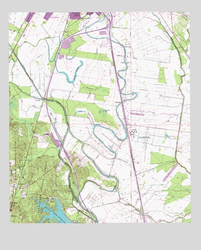
Woodworth East, LA USGS Topographic Map
Click on map above to begin viewing in our Map Viewer.

This topographic map contains these locations and features:
Feature Name Type Latitude Longitude GNIS ID View Map
Back BayouGutN31.1294°W92.3837°551813View Map
Bayou ClearStreamN31.1380°W92.4524°547012View Map
Bayou RobertStreamN31.1719°W92.4487°547024View Map
Bench SloughLakeN31.2025°W92.4518°547055View Map
Browns SpringSpringN31.1369°W92.4976°547130View Map
ChambersPopulated PlaceN31.1785°W92.4137°547207View Map
Chambers LakeLakeN31.1917°W92.4351°553947View Map
Chatlin Lake CanalCanalN31.1830°W92.3824°553960View Map
CloverdalePopulated PlaceN31.1988°W92.4765°547235View Map
Cloverdale CemeteryCemeteryN31.1774°W92.4771°547236View Map
CooleyPopulated PlaceN31.1769°W92.4843°547244View Map
Dry BayouGutN31.1924°W92.4874°547311View Map
East Prong Willow BayouGutN31.2327°W92.4799°547335View Map
Figgins CemeteryCemeteryN31.2202°W92.4207°547359View Map
Hard Times PlantationLocaleN31.2241°W92.4182°551844View Map
Harris SloughLakeN31.2141°W92.4617°547445View Map
Hughes BayouLakeN31.1915°W92.4480°547487View Map
Indian Creek DamDamN31.1302°W92.4618°556716View Map
InglewoodPopulated PlaceN31.2299°W92.4212°547510View Map
Inglewood PlantationLocaleN31.2321°W92.4196°551846View Map
Inglewood Plantation Historic DistrictParkN31.2238°W92.4185°551722View Map
LamouriePopulated PlaceN31.1319°W92.4118°548170View Map
Lamourie Baptist ChurchChurchN31.1394°W92.4237°554992View Map
Lamourie High School (historical)SchoolN31.1405°W92.4237°551727View Map
Lamourie Ward TwoCivilN31.1882°W92.3937°545169View Map
Lecompte Volunteer Fire Department Station 2BuildingN31.1415°W92.4247°2673132View Map
Little Bayou ClearStreamN31.1632°W92.4826°547589View Map
Louisiana State University AlexandriaSchoolN31.1786°W92.4144°555180View Map
MorelandPopulated PlaceN31.1969°W92.4232°555370View Map
Oakland Baptist ChurchChurchN31.1738°W92.4226°555532View Map
Parish Governing Authority District FCivilN31.2006°W92.3964°1930326View Map
Pecan BayouStreamN31.2402°W92.4932°547823View Map
Persimmon BayouStreamN31.2285°W92.3840°547831View Map
Plantation SloughLakeN31.2072°W92.4484°558289View Map
Rocky BayouStreamN31.2038°W92.4915°547902View Map
Saint John Baptist ChurchChurchN31.1307°W92.4104°551773View Map
Saint John CemeteryCemeteryN31.1307°W92.4104°547924View Map
Saint John ChurchChurchN31.1307°W92.4104°543825View Map
Second Union Baptist ChurchChurchN31.2199°W92.4193°556001View Map
Summerville AirstripAirportN31.1601°W92.4175°2717162View Map
Summerville Landing StripAirportN31.1610°W92.4224°557041View Map
Turpin SpurLocaleN31.2432°W92.4329°551793View Map
Turtle BayouLakeN31.2005°W92.4586°548098View Map
Willow BayouStreamN31.2085°W92.4979°548153View Map
Willow GlenPopulated PlaceN31.2466°W92.4324°548154View Map
Wise CemeteryCemeteryN31.1488°W92.4551°548157View Map
WoodworthPopulated PlaceN31.1466°W92.4974°556474View Map
Woodworth Police DepartmentBuildingN31.1472°W92.4994°2755289View Map
Woodworth Post OfficePost OfficeN31.1478°W92.4988°1631783View Map

Note: Coordinates in the location and feature list above are referenced to NAD83 datum.


Copyright (C) 2008-2024 Ryan Niemi / Sunset Dynamics ... All Rights Reserved