TopoQuest Logo
Do you find TopoQuest useful?
Help keep TopoQuest running and adding new maps/features by donating!
Bitcoin:  19c7KJd3qBynnjoSw5npx9KScwjBe4ifkT
Litecoin:  LXs6TkuXGGXo1vDsWCkWVdjQX94eUKd6ui
Home View Maps Find Maps Find Places Resources & Links


Woods Bluff, Alabama Topographic Map

USGS Map Title: Woods Bluff, AL
USGS Map MRC: 31088H1
DRG (GeoTIFF) Download: o31088h1.tif


Neighboring USGS Topographic Map Quads:


  Butler, AL  
32088A2
 

  Putnam, AL  
32088A1
 

  Nanafalia, AL  
32087A8
 

  Ararat, AL  
31088H2
 

  Woods Bluff, AL  
31088H1
 

  Morvin, AL  
31087H8
 

  Coffeeville Lock And Dam, AL  
31088G2
 

  Coffeeville, AL  
31088G1
 

  McEntyre, AL  
31087G8


Map MRC Location:

N32°
W89°
N32°
W88°
H8 H7 H6 H5 H4 H3 H2 H1
G8 G7 G6 G5 G4 G3 G2 G1
F8 F7 F6 F5 F4 F3 F2 F1
E8 E7 E6 E5 E4 E3 E2 E1
D8 D7 D6 D5 D4 D3 D2 D1
C8 C7 C6 C5 C4 C3 C2 C1
B8 B7 B6 B5 B4 B3 B2 B1
A8 A7 A6 A5 A4 A3 A2 A1
N31°
W89°
N31°
W88°

Woods Bluff, AL USGS 1:24K Topographic Map Preview:
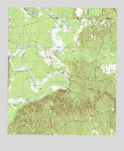
Woods Bluff, AL USGS Topographic Map
Click on map above to begin viewing in our Map Viewer.

This topographic map contains these locations and features:
Feature Name Type Latitude Longitude GNIS ID View Map
Barneys Lower LandingLocaleN31.9924°W88.0756°156029View Map
Barneys ShoalsBarN31.9779°W88.0764°139943View Map
Bashi CreekStreamN31.9565°W88.0728°113545View Map
Bashi Creek Public Use AreaParkN31.9590°W88.0683°113546View Map
Beach BluffCliffN31.9207°W88.0895°113621View Map
Big Bunny CreekStreamN31.9838°W88.0667°154988View Map
Big Cypress PondSwampN31.9509°W88.1081°114275View Map
Big SloughStreamN31.9363°W88.0708°114320View Map
Bunny LakeLakeN31.9843°W88.0589°115206View Map
Buttonwood BranchStreamN31.9646°W88.1000°139965View Map
Buxtion ChurchChurchN31.9807°W88.0275°164033View Map
Cade BarBarN31.9529°W88.0786°139966View Map
Cade BendBendN31.9557°W88.0792°139967View Map
Cade Bend Landing (historical)LocaleN31.9543°W88.0792°139968View Map
Campbell MountainSummitN31.9132°W88.0081°115502View Map
Campbells LandingLocaleN31.9610°W88.0689°164035View Map
Cowans Gin (historical)LocaleN31.9049°W88.1139°1730303View Map
Cowans PondLakeN31.9279°W88.0976°116754View Map
CunninghamPopulated PlaceN31.9004°W88.0761°156241View Map
Cunningham BendBendN31.9288°W88.0670°116966View Map
Cunningham BranchStreamN31.8840°W88.0903°116967View Map
Cunningham LandingLocaleN31.9121°W88.0847°156242View Map
Davis BluffCliffN31.9254°W88.0542°117100View Map
Dry CreekStreamN31.9346°W88.0728°117530View Map
Emery CreekStreamN31.9593°W88.1078°117974View Map
FailetownPopulated PlaceN31.9279°W88.0164°156331View Map
Ferrell BranchStreamN31.9154°W88.0486°139999View Map
Grangers BarBarN31.9402°W88.1125°133632View Map
Hatchet CemeteryCemeteryN31.8951°W88.1075°119843View Map
Little Bunny CreekStreamN31.9840°W88.0395°121721View Map
Log LandingLocaleN31.9265°W88.0533°133662View Map
McCartys BluffCliffN31.9474°W88.1231°140047View Map
McCartys Ferry (historical)CrossingN31.9521°W88.1233°140048View Map
McCartys LandingLocaleN31.9513°W88.1217°156677View Map
McNeiders (historical)Populated PlaceN31.9918°W88.0014°1730257View Map
Melton Spring BranchStreamN31.9615°W88.1100°122640View Map
Mitchells Woodyard LandingLocaleN31.9052°W88.1206°1730304View Map
Morvin Junior High SchoolSchoolN31.9729°W88.0245°133677View Map
Nobles Gin Landing (historical)LocaleN31.9577°W88.1067°133681View Map
Pickens (historical)LocaleN31.9785°W88.0650°133685View Map
Pickens LandingLocaleN31.9821°W88.0661°156880View Map
Quinn (historical)LocaleN31.9504°W88.1245°140096View Map
Quinns LandingLocaleN31.9374°W88.1167°156941View Map
Rock SpringsPopulated PlaceN31.9502°W88.0811°156980View Map
Rocky BranchStreamN31.9549°W88.1153°140110View Map
Schultys LandingLocaleN31.9393°W88.1011°157023View Map
SlaterPopulated PlaceN31.9935°W88.1000°157071View Map
Slaters Landing (historical)LocaleN31.9952°W88.1042°140128View Map
SmyerPopulated PlaceN31.8935°W88.0289°157082View Map
Whites BluffCliffN31.9196°W88.0650°128910View Map
Wicks ChapelChurchN31.9338°W88.0517°164149View Map
Wildcat LandingLocaleN31.9652°W88.0920°157258View Map
Witch CreekStreamN31.9224°W88.0553°129138View Map
Witch Creek ChurchChurchN31.8985°W88.0242°129139View Map
Woods BluffCliffN31.9338°W88.0603°1730357View Map
Woods BluffPopulated PlaceN31.9357°W88.0617°157280View Map
Woods Bluff Public Use AreaParkN31.9354°W88.0608°133736View Map
Woods Bluff ShoalBarN31.9371°W88.0672°140161View Map
Yellow BluffCliffN31.9088°W88.1125°140162View Map
Yellow BranchStreamN31.9374°W88.1014°129281View Map
Yellow BranchStreamN31.9460°W88.0250°129282View Map

Note: Coordinates in the location and feature list above are referenced to NAD83 datum.


Copyright (C) 2008-2024 Ryan Niemi / Sunset Dynamics ... All Rights Reserved