TopoQuest Logo
Do you find TopoQuest useful?
Help keep TopoQuest running and adding new maps/features by donating!
Bitcoin:  19c7KJd3qBynnjoSw5npx9KScwjBe4ifkT
Litecoin:  LXs6TkuXGGXo1vDsWCkWVdjQX94eUKd6ui
Home View Maps Find Maps Find Places Resources & Links


Putnam, Alabama Topographic Map

USGS Map Title: Putnam, AL
USGS Map MRC: 32088A1
DRG (GeoTIFF) Download: o32088a1.tif


Neighboring USGS Topographic Map Quads:


  Jachin, AL  
32088B2
 

  Pennington, AL  
32088B1
 

  Myrtlewood South, AL  
32087B8
 

  Butler, AL  
32088A2
 

  Putnam, AL  
32088A1
 

  Nanafalia, AL  
32087A8
 

  Ararat, AL  
31088H2
 

  Woods Bluff, AL  
31088H1
 

  Morvin, AL  
31087H8


Map MRC Location:

N33°
W89°
N33°
W88°
H8 H7 H6 H5 H4 H3 H2 H1
G8 G7 G6 G5 G4 G3 G2 G1
F8 F7 F6 F5 F4 F3 F2 F1
E8 E7 E6 E5 E4 E3 E2 E1
D8 D7 D6 D5 D4 D3 D2 D1
C8 C7 C6 C5 C4 C3 C2 C1
B8 B7 B6 B5 B4 B3 B2 B1
A8 A7 A6 A5 A4 A3 A2 A1
N32°
W89°
N32°
W88°

Putnam, AL USGS 1:24K Topographic Map Preview:
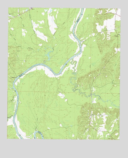
Putnam, AL USGS Topographic Map
Click on map above to begin viewing in our Map Viewer.

This topographic map contains these locations and features:
Feature Name Type Latitude Longitude GNIS ID View Map
B L Turners Landing (historical)LocaleN32.0618°W88.1056°137564View Map
Barneys Upper Landing (historical)LocaleN32.0607°W88.0708°137567View Map
Barries Gin Landing (historical)LocaleN32.0854°W88.0428°137568View Map
Bay Wash Landing (historical)LocaleN32.0368°W88.1125°137570View Map
Blue Rock (historical)LocaleN32.0090°W88.0917°137577View Map
Browns Landing (historical)LocaleN32.0454°W88.1167°139955View Map
Butler-Choctaw County AirportAirportN32.1165°W88.1238°129420View Map
Cotahoma CreekStreamN32.0879°W88.0789°116671View Map
Crooked CreekStreamN32.0357°W88.0083°137591View Map
Democrat (historical)LocaleN32.0146°W88.1147°137593View Map
Democrat LandingLocaleN32.0143°W88.1142°137594View Map
East Choctaw High SchoolSchoolN32.1249°W88.1006°165406View Map
Gays Ferry (historical)CrossingN32.0910°W88.0439°137604View Map
Gilmer BranchStreamN32.1032°W88.1000°118967View Map
Gooden Hill ChurchChurchN32.0232°W88.0206°119138View Map
Hornsboro (historical)Populated PlaceN32.0649°W88.0214°1730251View Map
Horse CreekStreamN32.0771°W88.0542°120409View Map
Hurricane CreekStreamN32.0896°W88.0833°120590View Map
Jacksons BendBendN32.0015°W88.1083°137614View Map
Kansas (historical)LocaleN32.0696°W88.0903°137616View Map
Lilly Grove Church (historical)ChurchN32.1121°W88.0733°140038View Map
Magnolia Landing (historical)LocaleN32.0126°W88.1170°140045View Map
Mellen CreekStreamN32.0413°W88.1145°152297View Map
Mount Mariah CemeteryCemeteryN32.0985°W88.0033°1805637View Map
Mount Moriah Baptist ChurchChurchN32.0988°W88.0033°123241View Map
Pearsons ShoalBarN32.0963°W88.0492°140166View Map
Perry BranchStreamN32.0021°W88.0136°112867View Map
Pineville Post Office (historical)Post OfficeN32.0079°W88.0381°166073View Map
Pritchetts Landing (historical)LocaleN32.0938°W88.0445°137657View Map
PutnamPopulated PlaceN32.0227°W88.0314°153093View Map
Putnam Baptist ChurchChurchN32.0232°W88.0303°151586View Map
Putnam CemeteryCemeteryN32.0101°W88.0342°125373View Map
Putnam Census Designated PlaceCensusN32.0181°W88.0331°2628603View Map
Putnam Elementary School (historical)SchoolN32.0232°W88.0217°151619View Map
Putnam Volunteer Fire DepartmentBuildingN32.0154°W88.0323°2691586View Map
Ridge CreekStreamN32.0074°W88.0933°153154View Map
Saint Mary United Methodist ChurchChurchN32.1165°W88.1184°153271View Map
Spencer CemeteryCemeteryN32.0838°W88.1150°127181View Map
Sucarbowa CreekStreamN32.0721°W88.0878°153595View Map
Sweetwater CreekStreamN32.0640°W88.0478°137673View Map
Turkey CreekStreamN32.0421°W88.0242°128157View Map
Turners (historical)LocaleN32.0618°W88.1050°137676View Map
Tuscahoma LandingLocaleN32.0582°W88.1150°158942View Map
Vaughn CreekStreamN32.0913°W88.1159°128423View Map
Wahalak CreekStreamN32.0215°W88.1178°153861View Map
Wahalak Landing (historical)LocaleN32.0251°W88.1164°140152View Map
Walters Lower Landing (historical)LocaleN32.0899°W88.0453°140154View Map
Walters Upper Landing (historical)LocaleN32.1201°W88.0445°140155View Map
Waters LandingLocaleN32.1049°W88.0528°140153View Map
White CemeteryCemeteryN32.0882°W88.1142°128863View Map

Note: Coordinates in the location and feature list above are referenced to NAD83 datum.


Copyright (C) 2008-2024 Ryan Niemi / Sunset Dynamics ... All Rights Reserved