TopoQuest Logo
Do you find TopoQuest useful?
Help keep TopoQuest running and adding new maps/features by donating!
Bitcoin:  19c7KJd3qBynnjoSw5npx9KScwjBe4ifkT
Litecoin:  LXs6TkuXGGXo1vDsWCkWVdjQX94eUKd6ui
Home View Maps Find Maps Find Places Resources & Links


Wolbach SW, Nebraska Topographic Map

USGS Map Title: Wolbach SW, NE
USGS Map MRC: 41098C4
DRG (GeoTIFF) Download: o41098c4.tif


Neighboring USGS Topographic Map Quads:


  Scotia NE, NE  
41098D5
 

  Wolbach, NE  
41098D4
 

  Wolbach NE, NE  
41098D3
 

  Elba, NE  
41098C5
 

  Wolbach SW, NE  
41098C4
 

  Cushing, NE  
41098C3
 

  Nysted, NE  
41098B5
 

  Saint Paul, NE  
41098B4
 

  Palmer, NE  
41098B3


Map MRC Location:

N42°
W99°
N42°
W98°
H8 H7 H6 H5 H4 H3 H2 H1
G8 G7 G6 G5 G4 G3 G2 G1
F8 F7 F6 F5 F4 F3 F2 F1
E8 E7 E6 E5 E4 E3 E2 E1
D8 D7 D6 D5 D4 D3 D2 D1
C8 C7 C6 C5 C4 C3 C2 C1
B8 B7 B6 B5 B4 B3 B2 B1
A8 A7 A6 A5 A4 A3 A2 A1
N41°
W99°
N41°
W98°

Wolbach SW, NE USGS 1:24K Topographic Map Preview:
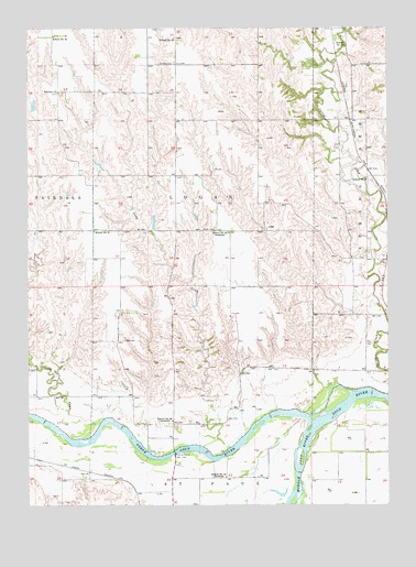
Wolbach SW, NE USGS Topographic Map
Click on map above to begin viewing in our Map Viewer.

This topographic map contains these locations and features:
Feature Name Type Latitude Longitude GNIS ID View Map
Cady CreekStreamN41.2681°W98.4262°827841View Map
Cedar CreekStreamN41.2728°W98.4740°827991View Map
Fairdale ChurchChurchN41.3581°W98.4895°829205View Map
Fairdale-Logan Election PrecinctCivilN41.3318°W98.4779°1928866View Map
Kolar DamDamN41.3710°W98.4199°1767141View Map
Kolar ReservoirReservoirN41.3714°W98.4207°1767142View Map
Lake CreekStreamN41.2564°W98.4059°830584View Map
Logan CemeteryCemeteryN41.2933°W98.4676°830822View Map
Loup Junction State Wildlife Management AreaParkN41.2708°W98.4115°1874775View Map
Middle Loup RiverStreamN41.2706°W98.4012°837295View Map
Miller DamDamN41.2947°W98.4572°1767572View Map
Miller ReservoirReservoirN41.2933°W98.4570°1767573View Map
North CemeteryCemeteryN41.3222°W98.4351°831677View Map
North Loup RiverStreamN41.2706°W98.4012°831710View Map
North Loup State Recreation AreaParkN41.2611°W98.4559°1874776View Map
Petersen DamDamN41.3381°W98.4742°1767574View Map
Petersen ReservoirReservoirN41.3392°W98.4756°1767575View Map
Saint Peter CemeteryCemeteryN41.3658°W98.4495°833086View Map
School Number 21SchoolN41.3217°W98.4773°836389View Map
School Number 23SchoolN41.3700°W98.3898°836420View Map
School Number 33LocaleN41.2572°W98.4317°836604View Map
School Number 36LocaleN41.2720°W98.4503°836637View Map
School Number 42LocaleN41.3214°W98.4306°836728View Map
School Number 43SchoolN41.3728°W98.4912°836731View Map
School Number 56SchoolN41.3725°W98.4495°836881View Map
School Number 6SchoolN41.3356°W98.3826°836916View Map
Township of LoganCivilN41.3333°W98.4392°1874739View Map

Note: Coordinates in the location and feature list above are referenced to NAD83 datum.


Copyright (C) 2008-2024 Ryan Niemi / Sunset Dynamics ... All Rights Reserved