TopoQuest Logo
Do you find TopoQuest useful?
Help keep TopoQuest running and adding new maps/features by donating!
Bitcoin:  19c7KJd3qBynnjoSw5npx9KScwjBe4ifkT
Litecoin:  LXs6TkuXGGXo1vDsWCkWVdjQX94eUKd6ui
Home View Maps Find Maps Find Places Resources & Links


Windy Hill, Arizona Topographic Map

USGS Map Title: Windy Hill, AZ
USGS Map MRC: 33111F1
DRG (GeoTIFF) Download: o33111f1.tif


Neighboring USGS Topographic Map Quads:


  Greenback Creek, AZ  
33111G2
 

  Armer Mountain, AZ  
33111G1
 

  Aztec Peak, AZ  
33110G8
 

  Theodore Roosevelt Dam, AZ  
33111F2
 

  Windy Hill, AZ  
33111F1
 

  Meddler Wash, AZ  
33110F8
 

  Pinyon Mountain, AZ  
33111E2
 

  Two Bar Mountain, AZ  
33111E1
 

  Salt River Peak, AZ  
33110E8


Map MRC Location:

N34°
W112°
N34°
W111°
H8 H7 H6 H5 H4 H3 H2 H1
G8 G7 G6 G5 G4 G3 G2 G1
F8 F7 F6 F5 F4 F3 F2 F1
E8 E7 E6 E5 E4 E3 E2 E1
D8 D7 D6 D5 D4 D3 D2 D1
C8 C7 C6 C5 C4 C3 C2 C1
B8 B7 B6 B5 B4 B3 B2 B1
A8 A7 A6 A5 A4 A3 A2 A1
N33°
W112°
N33°
W111°

Windy Hill, AZ USGS 1:24K Topographic Map Preview:
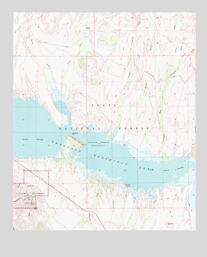
Windy Hill, AZ USGS Topographic Map
Click on map above to begin viewing in our Map Viewer.

This topographic map contains these locations and features:
Feature Name Type Latitude Longitude GNIS ID View Map
Aconye Ridge (historical)RidgeN33.6445°W111.1173°45646View Map
Armer GulchValleyN33.6781°W111.0579°25753View Map
Bell Plaza Shopping CenterLocaleN33.6417°W111.0321°14221View Map
Black Hills Study PlotAreaN33.6359°W111.0143°40883View Map
Bull MountainSummitN33.7219°W111.0719°40891View Map
Bull Mountain TankReservoirN33.7211°W111.0628°39300View Map
Bull TankReservoirN33.7051°W111.0749°39301View Map
Cave CanyonValleyN33.6670°W111.1086°27373View Map
Cholla CanyonValleyN33.6451°W111.1123°27612View Map
Connor WashStreamN33.7117°W111.0193°27857View Map
Cottonwood WashStreamN33.6637°W111.0265°28055View Map
Dagger SpringsSpringN33.7414°W111.0774°28246View Map
Dagger WashStreamN33.7039°W111.0946°28247View Map
Deadman CanyonValleyN33.6537°W111.1198°28333View Map
Eucalyptus CoveBayN33.6703°W111.0910°40890View Map
Frazier SubstationLocaleN33.6625°W111.1212°40887View Map
GrapevinePopulated PlaceN33.6512°W111.0490°29504View Map
Grapevine AirstripAirportN33.6409°W111.0566°45486View Map
Grapevine PointCapeN33.6512°W111.0490°40886View Map
Hat RanchLocaleN33.7303°W111.1143°40892View Map
Honey ButteSummitN33.6377°W111.1112°30089View Map
Honey Butte TankReservoirN33.6391°W111.0962°39510View Map
Honey Butte WellWellN33.6303°W111.1082°39511View Map
Jack Shoe RanchLocaleN33.7478°W111.0401°39540View Map
Mormon TankReservoirN33.7062°W111.0590°39639View Map
OwlheadLocaleN33.7000°W111.1007°23961View Map
Parker CreekStreamN33.7228°W111.0110°32692View Map
Porter Spring Recreation SiteParkN33.6670°W111.0935°33118View Map
Roosevelt EstatesLocaleN33.6306°W111.0026°40884View Map
Roundup HillSummitN33.6287°W111.0193°33843View Map
Saddle IslandIslandN33.6589°W111.0718°40885View Map
Salome CoveBayN33.6995°W111.0929°40889View Map
Salt River Bird ReservationParkN33.6667°W111.0646°42772View Map
Schell GulchValleyN33.6735°W111.0491°34129View Map
Schoolhouse CampgroundLocaleN33.6486°W111.0111°2670017View Map
Schoolhouse PointSummitN33.6559°W111.0135°39779View Map
Schoolhouse Recreation SiteParkN33.6500°W111.0101°34144View Map
Schoolhouse WashStreamN33.6589°W111.0646°34148View Map
Shelter IslandIslandN33.6681°W111.0807°40888View Map
Steamboat RockIslandN33.6806°W111.0848°34808View Map
Tank CreekStreamN33.6800°W111.0560°35130View Map
Theodore Roosevelt LakeReservoirN33.6846°W111.1218°42942View Map
Tin TankReservoirN33.7288°W111.0943°39837View Map
TontoLocaleN33.6417°W111.1160°40489View Map
Tonto Cliff DwellingsLocaleN33.6478°W111.1160°40511View Map
Tonto National MonumentParkN33.6484°W111.1136°35382View Map
Tonto National Monument HeadquartersBuildingN33.6445°W111.1129°22378View Map
Tonto Ranger Station HeliportAirportN33.6664°W111.1246°45488View Map
Windy HillSummitN33.6740°W111.0785°36309View Map
Windy Hill Boat RampLocaleN33.6700°W111.0843°39887View Map
Windy Hill CampLocaleN33.6614°W111.0922°2669728View Map
Windy Hill Recreation SiteParkN33.6703°W111.0873°39709View Map

Note: Coordinates in the location and feature list above are referenced to NAD83 datum.


Copyright (C) 2008-2024 Ryan Niemi / Sunset Dynamics ... All Rights Reserved