TopoQuest Logo
Do you find TopoQuest useful?
Help keep TopoQuest running and adding new maps/features by donating!
Bitcoin:  19c7KJd3qBynnjoSw5npx9KScwjBe4ifkT
Litecoin:  LXs6TkuXGGXo1vDsWCkWVdjQX94eUKd6ui
Home View Maps Find Maps Find Places Resources & Links


Armer Mountain, Arizona Topographic Map

USGS Map Title: Armer Mountain, AZ
USGS Map MRC: 33111G1
DRG (GeoTIFF) Download: o33111g1.tif


Neighboring USGS Topographic Map Quads:


  Picture Mountain, AZ  
33111H2
 

  Copper Mountain, AZ  
33111H1
 

  McFadden Peak, AZ  
33110H8
 

  Greenback Creek, AZ  
33111G2
 

  Armer Mountain, AZ  
33111G1
 

  Aztec Peak, AZ  
33110G8
 

  Theodore Roosevelt Dam, AZ  
33111F2
 

  Windy Hill, AZ  
33111F1
 

  Meddler Wash, AZ  
33110F8


Map MRC Location:

N34°
W112°
N34°
W111°
H8 H7 H6 H5 H4 H3 H2 H1
G8 G7 G6 G5 G4 G3 G2 G1
F8 F7 F6 F5 F4 F3 F2 F1
E8 E7 E6 E5 E4 E3 E2 E1
D8 D7 D6 D5 D4 D3 D2 D1
C8 C7 C6 C5 C4 C3 C2 C1
B8 B7 B6 B5 B4 B3 B2 B1
A8 A7 A6 A5 A4 A3 A2 A1
N33°
W112°
N33°
W111°

Armer Mountain, AZ USGS 1:24K Topographic Map Preview:
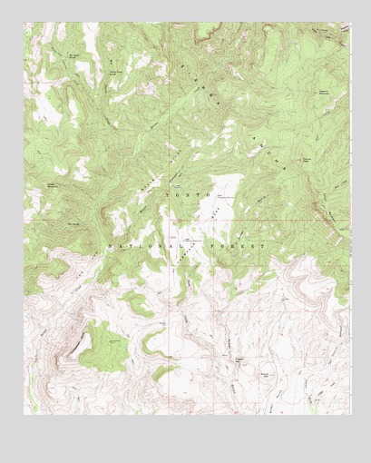
Armer Mountain, AZ USGS Topographic Map
Click on map above to begin viewing in our Map Viewer.

This topographic map contains these locations and features:
Feature Name Type Latitude Longitude GNIS ID View Map
Armer MountainSummitN33.8209°W111.0110°25754View Map
Big Cherry CreekStreamN33.8317°W111.0873°26250View Map
Boyer CabinLocaleN33.8223°W111.0673°40900View Map
Boyer CanyonValleyN33.8023°W111.0926°26697View Map
Boyer RidgeRidgeN33.8273°W111.0723°26698View Map
Boyer Trail One Hundred FortyeightTrailN33.8403°W111.0243°39287View Map
Butte TankReservoirN33.7823°W111.0973°39308View Map
Cellar CreekStreamN33.7509°W111.0137°27452View Map
Center Ridge TankReservoirN33.7776°W111.0796°39332View Map
Cherry Creek SpringSpringN33.8587°W111.0928°27547View Map
Chubb MountainSummitN33.8231°W111.1168°27624View Map
Connor CanyonValleyN33.7625°W111.0160°27856View Map
Dust Bowl TankReservoirN33.7867°W111.0273°28689View Map
Dutchwoman ButteSummitN33.7764°W111.1015°28706View Map
Dutchwoman TankReservoirN33.7734°W111.0926°28707View Map
Hale SpringSpringN33.8107°W111.1036°30063View Map
Hopkins MountainSummitN33.8525°W111.0126°30110View Map
Hopkins SpringSpringN33.8687°W111.0232°39513View Map
Little Cherry CreekStreamN33.8464°W111.0954°31047View Map
Lower Thompson Mesa TankReservoirN33.8056°W111.0640°31384View Map
Reynolds CreekStreamN33.8717°W111.0043°33592View Map
Round MountainSummitN33.7628°W111.0312°33824View Map
Salome WildernessReserveN33.8389°W111.0665°2035280View Map
Tanner PeakSummitN33.8312°W111.0190°35145View Map
The JugCliffN33.7973°W111.1004°35228View Map
Thompson MesaSummitN33.8067°W111.0576°35284View Map
Tin House SpringSpringN33.8638°W111.1083°35333View Map
Tucker BoxBasinN33.7673°W111.0448°35493View Map
Upper Thompson Mesa TankReservoirN33.8196°W111.0515°13127View Map
Whiskey TankReservoirN33.7647°W111.0584°39879View Map

Note: Coordinates in the location and feature list above are referenced to NAD83 datum.


Copyright (C) 2008-2024 Ryan Niemi / Sunset Dynamics ... All Rights Reserved