TopoQuest Logo
Do you find TopoQuest useful?
Help keep TopoQuest running and adding new maps/features by donating!
Bitcoin:  19c7KJd3qBynnjoSw5npx9KScwjBe4ifkT
Litecoin:  LXs6TkuXGGXo1vDsWCkWVdjQX94eUKd6ui
Home View Maps Find Maps Find Places Resources & Links


Willington, South Carolina Topographic Map

USGS Map Title: Willington, SC
USGS Map MRC: 33082H4
DRG (GeoTIFF) Download: o33082h4.tif


Neighboring USGS Topographic Map Quads:


  Calhoun Falls, SC  
34082A5
 

  Calhoun Creek, SC  
34082A4
 

  Verdery, SC  
34082A3
 

  Chennault, GA  
33082H5
 

  Willington, SC  
33082H4
 

  McCormick, SC  
33082H3
 

  Metasville, GA  
33082G5
 

  Lincolnton, GA  
33082G4
 

  Plum Branch, SC  
33082G3


Map MRC Location:

N34°
W83°
N34°
W82°
H8 H7 H6 H5 H4 H3 H2 H1
G8 G7 G6 G5 G4 G3 G2 G1
F8 F7 F6 F5 F4 F3 F2 F1
E8 E7 E6 E5 E4 E3 E2 E1
D8 D7 D6 D5 D4 D3 D2 D1
C8 C7 C6 C5 C4 C3 C2 C1
B8 B7 B6 B5 B4 B3 B2 B1
A8 A7 A6 A5 A4 A3 A2 A1
N33°
W83°
N33°
W82°

Willington, SC USGS 1:24K Topographic Map Preview:
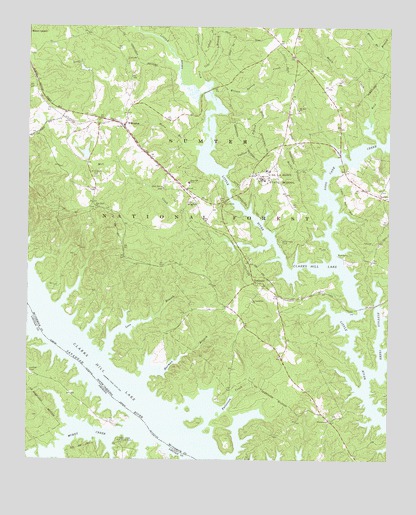
Willington, SC USGS Topographic Map
Click on map above to begin viewing in our Map Viewer.

This topographic map contains these locations and features:
Feature Name Type Latitude Longitude GNIS ID View Map
Badwell CemeteryCemeteryN33.9265°W82.3782°1229168View Map
Bold BranchStreamN33.9718°W82.3818°1229441View Map
BordeauxPopulated PlaceN33.9265°W82.4207°1246947View Map
Bordeaux CemeteryCemeteryN33.9259°W82.4215°1229178View Map
Bordeaux ChurchChurchN33.9262°W82.4215°1229179View Map
Bordeaux School (historical)SchoolN33.9223°W82.4276°1229180View Map
Buffalo CreekStreamN33.9004°W82.3810°1247049View Map
Buffalo Creek Recreation AreaParkN33.8957°W82.3790°1229184View Map
Clay BranchStreamN33.9423°W82.4429°1252044View Map
Cole BranchStreamN33.9879°W82.4404°1229575View Map
Conner CreekStreamN33.9846°W82.4390°1247368View Map
De La Howe State SchoolSchoolN33.9565°W82.4185°1247503View Map
De La Howe TombCemeteryN33.9390°W82.4121°1247504View Map
Gibert Rosenwald School (historical)SchoolN33.9482°W82.4771°1229199View Map
Green Olive School (historical)SchoolN33.9779°W82.4407°1229201View Map
Harman BranchStreamN33.8973°W82.4596°1245908View Map
Hickory Knob State ParkParkN33.8918°W82.4179°1229205View Map
Hickory Knob State ParkParkN33.8912°W82.4149°1252005View Map
Hickory Knob SubdivisionPopulated PlaceN33.8929°W82.4340°1229206View Map
Holy Rock ChurchChurchN33.9476°W82.4762°1229811View Map
Horse BranchStreamN33.9660°W82.4407°1229820View Map
Hosannah ChurchChurchN33.8865°W82.3946°1246078View Map
Lees BranchStreamN33.9051°W82.4724°1229899View Map
Leroys Ferry (historical)CrossingN33.9168°W82.4979°1229214View Map
Leroys Ferry (historical)CrossingN33.9168°W82.4979°352096View Map
Leroys Ferry Recreation AreaParkN33.9215°W82.4893°1229215View Map
LethiaPopulated PlaceN33.9662°W82.4121°1252048View Map
Little Mill ChurchChurchN33.9535°W82.4526°1246411View Map
Little Mill School (historical)SchoolN33.9501°W82.4449°1229216View Map
Little River QuarryMineN33.9432°W82.4293°1229217View Map
Little River Quarry Boat RampLocaleN33.9501°W82.4304°1252014View Map
Long Cane BridgeBridgeN33.9618°W82.3915°1229220View Map
Long Cane Creek Boat RampLocaleN33.9346°W82.3926°1252013View Map
Long Cane Creek Picnic AreaParkN33.9335°W82.3910°1229221View Map
Long Crane Creek CampgroundLocaleN33.9337°W82.3776°1230596View Map
Ludlow BranchStreamN33.9607°W82.4285°1229960View Map
Mathis CreekStreamN33.9579°W82.4015°1246556View Map
McKissick Memorial ChapelChurchN33.9565°W82.4199°1229229View Map
Mill BranchStreamN33.9623°W82.3904°1252051View Map
Mill BridgeBridgeN33.9510°W82.4299°1252052View Map
Mill CreekStreamN33.9379°W82.4165°1230009View Map
Mill CreekStreamN33.8754°W82.4976°328787View Map
Mims School Number 3SchoolN33.9554°W82.4440°1246689View Map
Monroe Ridge Hunt CampgroundLocaleN33.9893°W82.4212°1230597View Map
Morrow BridgeBridgeN33.9823°W82.4379°1229234View Map
Mount Carmel DivisionCivilN33.9833°W82.4483°1938355View Map
Mount Zion ChurchChurchN33.9762°W82.4062°1249712View Map
Mount Zion School (historical)SchoolN33.9765°W82.4065°1229242View Map
Murry CreekStreamN33.8832°W82.4640°328964View Map
Murry Creek Camping AreaLocaleN33.8798°W82.4679°319170View Map
Murry Island (historical)IslandN33.8923°W82.4868°344082View Map
New Bordeaux ChurchChurchN33.9240°W82.3951°1229243View Map
Old Willington Church (historical)ChurchN33.9546°W82.4762°1229247View Map
Patterson CreekStreamN33.8876°W82.4465°1250036View Map
Remsens Ferry (historical)CrossingN33.8982°W82.4762°1252056View Map
Remsens Ferry (historical)CrossingN33.8982°W82.4762°352097View Map
Rocky BranchStreamN33.9982°W82.3757°1230248View Map
Rocky Creek Church (historical)ChurchN33.9485°W82.4776°1229270View Map
Saint Charlotte School (historical)SchoolN33.9207°W82.4224°1229272View Map
Saint Charlottes ChurchChurchN33.9207°W82.4221°1250503View Map
Scott CreekStreamN33.9876°W82.4482°1230312View Map
South Carolina Noname 35003 D-0641 DamDamN33.9618°W82.4799°1238871View Map
Springfield ChurchChurchN33.9496°W82.4421°1251011View Map
Welch CreekStreamN33.9779°W82.3815°1230470View Map
Willing Church (historical)ChurchN33.9715°W82.4754°1229284View Map
WillingtonPopulated PlaceN33.9721°W82.4668°1230504View Map
Willington CemeteryCemeteryN33.9571°W82.4760°1230505View Map
Willington Census Designated PlaceCensusN33.9687°W82.4576°2403030View Map
Willington Presbyterian ChurchChurchN33.9704°W82.4676°1229285View Map
Willington School (historical)SchoolN33.9718°W82.4679°1229286View Map
Wilson Spring CreekStreamN33.9812°W82.4357°1230511View Map

Note: Coordinates in the location and feature list above are referenced to NAD83 datum.


Copyright (C) 2008-2024 Ryan Niemi / Sunset Dynamics ... All Rights Reserved