TopoQuest Logo
Do you find TopoQuest useful?
Help keep TopoQuest running and adding new maps/features by donating!
Bitcoin:  19c7KJd3qBynnjoSw5npx9KScwjBe4ifkT
Litecoin:  LXs6TkuXGGXo1vDsWCkWVdjQX94eUKd6ui
Home View Maps Find Maps Find Places Resources & Links


Whitewater, Missouri Topographic Map

USGS Map Title: Whitewater, MO
USGS Map MRC: 37089B7
DRG (GeoTIFF) Download: o37089b7.tif


Neighboring USGS Topographic Map Quads:


  Marble Hill, MO  
37089C8
 

  Burfordville, MO  
37089C7
 

  Gordonville, MO  
37089C6
 

  Dongola, MO  
37089B8
 

  Whitewater, MO  
37089B7
 

  Chaffee, MO  
37089B6
 

  Advance, MO  
37089A8
 

  Bell City, MO  
37089A7
 

  Oran, MO  
37089A6


Map MRC Location:

N38°
W90°
N38°
W89°
H8 H7 H6 H5 H4 H3 H2 H1
G8 G7 G6 G5 G4 G3 G2 G1
F8 F7 F6 F5 F4 F3 F2 F1
E8 E7 E6 E5 E4 E3 E2 E1
D8 D7 D6 D5 D4 D3 D2 D1
C8 C7 C6 C5 C4 C3 C2 C1
B8 B7 B6 B5 B4 B3 B2 B1
A8 A7 A6 A5 A4 A3 A2 A1
N37°
W90°
N37°
W89°

Whitewater, MO USGS 1:24K Topographic Map Preview:
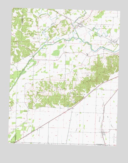
Whitewater, MO USGS Topographic Map
Click on map above to begin viewing in our Map Viewer.

This topographic map contains these locations and features:
Feature Name Type Latitude Longitude GNIS ID View Map
AllenvillePopulated PlaceN37.2217°W89.7576°713227View Map
Allenville Covered BridgeBridgeN37.2153°W89.7670°730555View Map
ArborPopulated PlaceN37.1592°W89.8023°713366View Map
Block HoleBasinN37.2131°W89.8404°714374View Map
CliffPopulated PlaceN37.1687°W89.7884°740751View Map
Council Ridge School (historical)SchoolN37.2459°W89.8584°748041View Map
Crooked CreekStreamN37.2234°W89.7962°749529View Map
Ditch Ward School (historical)SchoolN37.1373°W89.8051°748047View Map
Fairview ChurchChurchN37.1714°W89.8431°717772View Map
Frazier CemeteryCemeteryN37.1384°W89.8687°718185View Map
Gizzard CreekStreamN37.1914°W89.8612°718476View Map
Green CoxPopulated PlaceN37.1406°W89.8390°740882View Map
Green Cox School (historical)SchoolN37.1409°W89.8415°730554View Map
Hickory RidgeRidgeN37.1798°W89.7995°719491View Map
Hickory RidgePopulated PlaceN37.1734°W89.8051°730556View Map
Hickory Ridge School (historical)SchoolN37.1759°W89.8029°748046View Map
Hitt CemeteryCemeteryN37.1756°W89.8023°719638View Map
Horseshoe Bend SloughGutN37.2278°W89.7756°719861View Map
Kenyon CemeteryCemeteryN37.1898°W89.7865°720548View Map
Mansion CemeteryCemeteryN37.2187°W89.8681°721809View Map
Moore School (historical)SchoolN37.2026°W89.8448°748042View Map
Oak Valley SchoolSchoolN37.2006°W89.7929°748044View Map
Passover CemeteryCemeteryN37.2256°W89.8459°724071View Map
Passover ChurchChurchN37.2262°W89.8523°724072View Map
Proffer CemeteryCemeteryN37.2220°W89.8476°724948View Map
RandlesPopulated PlaceN37.1378°W89.7676°725098View Map
Round Pond (historical)LakeN37.1998°W89.7948°730557View Map
Round Pond Church (historical)ChurchN37.1978°W89.8004°748045View Map
Rum BranchPopulated PlaceN37.1576°W89.8526°725661View Map
Rum Branch Church (historical)ChurchN37.1542°W89.8537°730559View Map
School Number R 5SchoolN37.2089°W89.7859°755399View Map
Stroderville (historical)Populated PlaceN37.2467°W89.8132°730558View Map
Stroderville CemeteryCemeteryN37.2473°W89.8120°727187View Map
Stroderville SchoolSchoolN37.2392°W89.8143°748043View Map
TankLocaleN37.1628°W89.7976°740595View Map
Town of WhitewaterCivilN37.2368°W89.7978°2397743View Map
Township of WelchCivilN37.1796°W89.7743°766403View Map
Trinity ChurchChurchN37.2103°W89.8118°727785View Map
Upper Castor RiverStreamN37.2171°W89.8361°755864View Map
Village of AllenvilleCivilN37.2218°W89.7555°2397938View Map
WhitewaterPopulated PlaceN37.2376°W89.7959°728793View Map
Whitewater Fire Protection District Station 1BuildingN37.2392°W89.7944°2620997View Map
Whitewater Post OfficePost OfficeN37.2370°W89.7969°2782736View Map

Note: Coordinates in the location and feature list above are referenced to NAD83 datum.


Copyright (C) 2008-2024 Ryan Niemi / Sunset Dynamics ... All Rights Reserved