TopoQuest Logo
Do you find TopoQuest useful?
Help keep TopoQuest running and adding new maps/features by donating!
Bitcoin:  19c7KJd3qBynnjoSw5npx9KScwjBe4ifkT
Litecoin:  LXs6TkuXGGXo1vDsWCkWVdjQX94eUKd6ui
Home View Maps Find Maps Find Places Resources & Links


Whites Creek, Tennessee Topographic Map

USGS Map Title: Whites Creek, TN
USGS Map MRC: 36086C7
DRG (GeoTIFF) Download: o36086c7.tif


Neighboring USGS Topographic Map Quads:


  Springfield South, TN  
36086D8
 

  Greenbrier, TN  
36086D7
 

  White House, TN  
36086D6
 

  Forest Grove, TN  
36086C8
 

  Whites Creek, TN  
36086C7
 

  Goodlettsville, TN  
36086C6
 

  Scottsboro, TN  
36086B8
 

  Nashville West, TN  
36086B7
 

  Nashville East, TN  
36086B6


Map MRC Location:

N37°
W87°
N37°
W86°
H8 H7 H6 H5 H4 H3 H2 H1
G8 G7 G6 G5 G4 G3 G2 G1
F8 F7 F6 F5 F4 F3 F2 F1
E8 E7 E6 E5 E4 E3 E2 E1
D8 D7 D6 D5 D4 D3 D2 D1
C8 C7 C6 C5 C4 C3 C2 C1
B8 B7 B6 B5 B4 B3 B2 B1
A8 A7 A6 A5 A4 A3 A2 A1
N36°
W87°
N36°
W86°

Whites Creek, TN USGS 1:24K Topographic Map Preview:
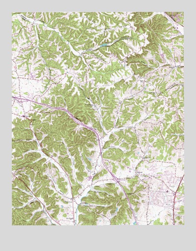
Whites Creek, TN USGS Topographic Map
Click on map above to begin viewing in our Map Viewer.

This topographic map contains these locations and features:
Feature Name Type Latitude Longitude GNIS ID View Map
AdcockCemeteryN36.3662°W86.8319°1644152View Map
Alex Green Elementary SchoolSchoolN36.2537°W86.8321°1304790View Map
BakersPopulated PlaceN36.3723°W86.7600°1304933View Map
Beacon Baptist ChurchChurchN36.2759°W86.7603°2453566View Map
Bear HollowValleyN36.3005°W86.8583°1276621View Map
Beech Grove CemeteryCemeteryN36.2900°W86.7808°1324289View Map
Beech Grove ChurchChurchN36.2901°W86.7803°1305064View Map
BellshirePopulated PlaceN36.2662°W86.7681°1313375View Map
Bellshire Assembly of God ChurchChurchN36.2670°W86.7591°2453570View Map
Bellshire Elementary SchoolSchoolN36.2698°W86.7622°1324306View Map
Bellshire Shopping CenterLocaleN36.2678°W86.7575°1324307View Map
Bellshire United Methodist ChurchChurchN36.2628°W86.7622°1324308View Map
Bennett HollowValleyN36.2717°W86.8166°1277017View Map
Browns LakeReservoirN36.3558°W86.8077°1278630View Map
Browns Lake DamDamN36.3555°W86.8092°1307202View Map
Carney CreekStreamN36.2651°W86.8567°1279691View Map
Claylick CreekStreamN36.2984°W86.8075°1305948View Map
Commissioner District 3CivilN36.2961°W86.7945°2464136View Map
Community Baptist ChurchChurchN36.2664°W86.7564°2453682View Map
Crocker Spring BranchStreamN36.3012°W86.8047°1281632View Map
Crocker Springs DamDamN36.3201°W86.8156°1307198View Map
Crocker Springs LakeReservoirN36.3203°W86.8157°1281633View Map
Cummings BranchStreamN36.3048°W86.8008°1306233View Map
DalemerePopulated PlaceN36.2828°W86.7722°1313398View Map
Devils ElbowBendN36.3120°W86.8603°1282395View Map
Dickerson Road Baptist ChurchChurchN36.2563°W86.7572°2453691View Map
Dividing RidgeRidgeN36.3662°W86.8094°1282512View Map
Druard HollowValleyN36.2937°W86.8089°1282812View Map
Dry Fork (historical)Populated PlaceN36.2587°W86.8522°1313400View Map
Dukes CemeteryCemeteryN36.2906°W86.8469°1283117View Map
Earthman ForkStreamN36.2617°W86.8269°1303444View Map
First Baptist Church of JoeltonChurchN36.3145°W86.8650°1646346View Map
GermantownPopulated PlaceN36.2795°W86.8736°1285319View Map
Gordons Store (historical)LocaleN36.3073°W86.7858°1324522View Map
High Point Store (historical)LocaleN36.3381°W86.7867°1324552View Map
Hunters Lane High SchoolSchoolN36.2780°W86.7537°2454094View Map
Interchange 35CrossingN36.3242°W86.8683°1313420View Map
Interchange 40CrossingN36.2770°W86.7997°1313421View Map
Ivy PointPopulated PlaceN36.3487°W86.7925°1289132View Map
Ivy Point CemeteryCemeteryN36.3489°W86.7919°1646378View Map
Ivy Point Church of ChristChurchN36.3487°W86.7922°1324578View Map
JoeltonPopulated PlaceN36.3131°W86.8653°1306624View Map
Joelton Air Force Station (historical)MilitaryN36.3378°W86.8606°2087769View Map
Joelton CemeteryCemeteryN36.3145°W86.8647°1646381View Map
Joelton Elementary SchoolSchoolN36.3145°W86.8661°1324583View Map
Joelton Middle SchoolSchoolN36.3139°W86.8664°1324584View Map
Joelton Post OfficePost OfficeN36.3164°W86.8648°1652331View Map
Johnson HollowValleyN36.2670°W86.8346°1289623View Map
Kaufman HollowValleyN36.2629°W86.8248°1289916View Map
Lakewood DamDamN36.3484°W86.7650°1302528View Map
Lakewood LakeReservoirN36.3495°W86.7656°1302527View Map
LicktonPopulated PlaceN36.3014°W86.8100°1291256View Map
Little CreekPopulated PlaceN36.2789°W86.7856°1315413View Map
Little CreekStreamN36.2723°W86.8172°1291450View Map
Little Creek Community CenterBuildingN36.2784°W86.7872°1324600View Map
Little Creek School (historical)SchoolN36.2789°W86.7875°1324601View Map
Living Water MinistriesChurchN36.2763°W86.7517°2453780View Map
Mackie ValleyValleyN36.2504°W86.8041°1292453View Map
New Wine MinistriesChurchN36.2621°W86.7571°2453586View Map
Oak Grove School (historical)SchoolN36.3678°W86.8125°1316500View Map
Paradise RidgeRidgeN36.3462°W86.8039°1296759View Map
Pathway Christian CenterChurchN36.2890°W86.7839°2453592View Map
Pioneer Christian AcademySchoolN36.2959°W86.7733°1324687View Map
Prock HollowValleyN36.2805°W86.8172°1298554View Map
Ridgepost (historical)Populated PlaceN36.3473°W86.8744°1313485View Map
Shaw BranchStreamN36.3048°W86.8008°1301291View Map
Sportsmans LakeReservoirN36.2592°W86.7988°1302454View Map
Sportsmans Lake DamDamN36.2584°W86.8000°1302455View Map
Spring Hill CemeteryCemeteryN36.3662°W86.8117°1644434View Map
Spring Hill ChurchChurchN36.3639°W86.8083°1303769View Map
Strait Word Baptist ChurchChurchN36.2624°W86.7567°2453643View Map
Sulphur BranchStreamN36.3695°W86.8592°1271766View Map
The Carpenter Shop ChurchChurchN36.2666°W86.7564°2453646View Map
Trantham CreekStreamN36.2648°W86.8247°1272844View Map
Union HillPopulated PlaceN36.3342°W86.7792°1273232View Map
Union Hill CemeteryCemeteryN36.3264°W86.7711°1646441View Map
Union Hill ChurchChurchN36.3267°W86.7708°1304254View Map
Union Hill School (historical)SchoolN36.3342°W86.7778°1324806View Map
Walkers ChurchChurchN36.3426°W86.7575°1304341View Map
Weaver School (historical)SchoolN36.2820°W86.8369°1324814View Map
Whites CreekPopulated PlaceN36.2659°W86.8308°1274455View Map
Whites Creek Comprehensive High SchoolSchoolN36.2773°W86.8186°1324834View Map
Whites Creek High SchoolSchoolN36.2731°W86.8185°2454142View Map
Whites Creek ParkParkN36.2751°W86.8183°1324836View Map
Whites Creek Post OfficePost OfficeN36.2645°W86.8311°1652339View Map
Whites Creek Springs (historical)Populated PlaceN36.3156°W86.7986°1313504View Map
Williams HillsPopulated PlaceN36.3376°W86.8594°1313507View Map
WLAC-AM (Nashville)TowerN36.2709°W86.7567°1639969View Map
WMAK-FM (Hendersonville)TowerN36.2973°W86.7531°1640119View Map
WTVF-TV (Nashville)TowerN36.2681°W86.7883°1640165View Map

Note: Coordinates in the location and feature list above are referenced to NAD83 datum.


Copyright (C) 2008-2024 Ryan Niemi / Sunset Dynamics ... All Rights Reserved