TopoQuest Logo
Do you find TopoQuest useful?
Help keep TopoQuest running and adding new maps/features by donating!
Bitcoin:  19c7KJd3qBynnjoSw5npx9KScwjBe4ifkT
Litecoin:  LXs6TkuXGGXo1vDsWCkWVdjQX94eUKd6ui
Home View Maps Find Maps Find Places Resources & Links


Forest Grove, Tennessee Topographic Map

USGS Map Title: Forest Grove, TN
USGS Map MRC: 36086C8
DRG (GeoTIFF) Download: o36086c8.tif


Neighboring USGS Topographic Map Quads:


  Pleasant View, TN  
36087D1
 

  Springfield South, TN  
36086D8
 

  Greenbrier, TN  
36086D7
 

  Ashland City, TN  
36087C1
 

  Forest Grove, TN  
36086C8
 

  Whites Creek, TN  
36086C7
 

  Lillamay, TN  
36087B1
 

  Scottsboro, TN  
36086B8
 

  Nashville West, TN  
36086B7


Map MRC Location:

N37°
W87°
N37°
W86°
H8 H7 H6 H5 H4 H3 H2 H1
G8 G7 G6 G5 G4 G3 G2 G1
F8 F7 F6 F5 F4 F3 F2 F1
E8 E7 E6 E5 E4 E3 E2 E1
D8 D7 D6 D5 D4 D3 D2 D1
C8 C7 C6 C5 C4 C3 C2 C1
B8 B7 B6 B5 B4 B3 B2 B1
A8 A7 A6 A5 A4 A3 A2 A1
N36°
W87°
N36°
W86°

Forest Grove, TN USGS 1:24K Topographic Map Preview:
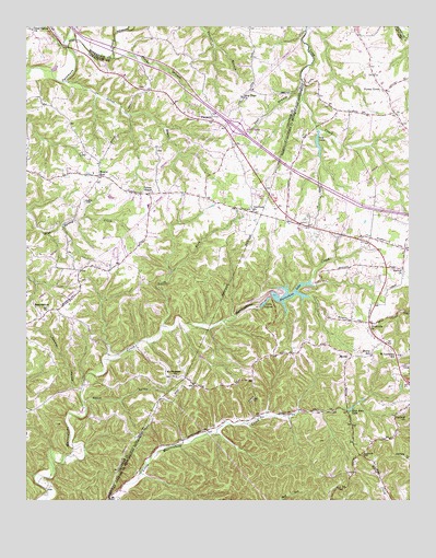
Forest Grove, TN USGS Topographic Map
Click on map above to begin viewing in our Map Viewer.

This topographic map contains these locations and features:
Feature Name Type Latitude Longitude GNIS ID View Map
Bear BranchStreamN36.3570°W86.9103°1276559View Map
BearwallowPopulated PlaceN36.2984°W86.9953°1276660View Map
Bearwallow ChurchChurchN36.3078°W86.9825°1317239View Map
Bearwallow School (historical)SchoolN36.3003°W86.9931°1317238View Map
Beech HollowValleyN36.2764°W86.9810°1276849View Map
Commissioner District 1CivilN36.2629°W86.8947°2464224View Map
Commissioner District 2CivilN36.3331°W86.9785°2463904View Map
Crocker HollowValleyN36.2795°W86.9824°1281631View Map
East Cheatham Elementary SchoolSchoolN36.3278°W86.9603°1317240View Map
Evans Airport (historical)AirportN36.2964°W86.9417°1301412View Map
Forest GrovePopulated PlaceN36.3578°W86.8828°1284582View Map
Forest Grove CemeteryCemeteryN36.3620°W86.8897°1646347View Map
Forest Grove School (historical)SchoolN36.3581°W86.8839°1324490View Map
Fosters Store (historical)LocaleN36.3117°W86.8828°1324498View Map
Glen Echo LakeLakeN36.2743°W86.8941°1285498View Map
Good Spring ChurchChurchN36.3739°W86.9981°1285629View Map
GreenvillePopulated PlaceN36.2970°W86.8883°1647714View Map
Greenville CemeteryCemeteryN36.2964°W86.8867°1646361View Map
Greenville ChurchChurchN36.2967°W86.8872°1306521View Map
Gupton CemeteryCemeteryN36.3289°W86.9811°1286451View Map
Hoffasville (historical)Populated PlaceN36.3367°W86.9986°1310757View Map
Hollis CreekStreamN36.3698°W86.9867°1288075View Map
Interchange 31CrossingN36.3487°W86.9317°1310759View Map
Joelton ChurchChurchN36.3101°W86.8767°1306625View Map
Jones BranchStreamN36.3606°W86.9872°1289703View Map
Lake LouiseLakeN36.3022°W86.9224°1292108View Map
Long BranchStreamN36.3478°W86.9053°1291891View Map
Marrowbone DamDamN36.3051°W86.9200°1302494View Map
Marrowbone LakeReservoirN36.3045°W86.9141°1302493View Map
MornyPopulated PlaceN36.2881°W86.8939°1294403View Map
Morny Elementary SchoolSchoolN36.2887°W86.8872°1648436View Map
Mount Pleasant ChurchChurchN36.2826°W86.9511°1294776View Map
Mount Pleasant School (historical)SchoolN36.2795°W86.9719°1317237View Map
Mount ZionPopulated PlaceN36.3359°W86.9767°1294856View Map
Mount Zion Freewill Baptist ChurchChurchN36.3339°W86.9767°1317236View Map
Mount Zion School (historical)SchoolN36.3362°W86.9783°1317241View Map
Mudlick CreekStreamN36.2981°W86.9319°1313467View Map
Nashville Fire Department Station 30BuildingN36.3165°W86.8761°2654115View Map
New Hope Freewill Baptist ChurchChurchN36.3567°W86.9303°1295560View Map
North Fork Marrowbone CreekStreamN36.2964°W86.9558°1295899View Map
Oakland CemeteryCemeteryN36.2725°W86.8778°1646402View Map
Oakland ChurchChurchN36.2728°W86.8769°1296185View Map
Oakwood ChurchChurchN36.3262°W86.9264°1296213View Map
Paines ChapelChurchN36.3314°W86.9594°1296656View Map
Pals LakeReservoirN36.3439°W86.9048°1296706View Map
Pals Lake DamDamN36.3467°W86.9053°1307201View Map
Paradise RidgeRidgeN36.3120°W86.8931°1313477View Map
Pinedale Church (historical)ChurchN36.2703°W86.9369°1324686View Map
Pinhook HillSummitN36.2628°W86.8889°1297666View Map
PinnaclePopulated PlaceN36.3501°W86.9397°1297677View Map
Pinnacle School (historical)SchoolN36.3503°W86.9389°1317242View Map
Pleasant View Volunteer Fire Department Station 2BuildingN36.3411°W86.9426°2653914View Map
Procks BranchStreamN36.3670°W86.9719°1298556View Map
Rest (historical)Populated PlaceN36.3106°W86.9822°1310756View Map
Saint Lawrence Catholic ChurchChurchN36.2870°W86.8797°1646426View Map
Saint Lawrence SchoolSchoolN36.2884°W86.8778°1300461View Map
Setters LakeReservoirN36.2734°W86.9098°1313487View Map
Setters School (historical)SchoolN36.2726°W86.9236°1324757View Map
WestPopulated PlaceN36.2737°W86.8956°1313501View Map
Westeria (historical)Populated PlaceN36.3298°W86.9414°1310758View Map
WZEZ-FM (Nashville)TowerN36.2748°W86.8861°1640117View Map

Note: Coordinates in the location and feature list above are referenced to NAD83 datum.


Copyright (C) 2008-2024 Ryan Niemi / Sunset Dynamics ... All Rights Reserved