TopoQuest Logo
Do you find TopoQuest useful?
Help keep TopoQuest running and adding new maps/features by donating!
Bitcoin:  19c7KJd3qBynnjoSw5npx9KScwjBe4ifkT
Litecoin:  LXs6TkuXGGXo1vDsWCkWVdjQX94eUKd6ui
Home View Maps Find Maps Find Places Resources & Links


White Bluff, Tennessee Topographic Map

USGS Map Title: White Bluff, TN
USGS Map MRC: 36087A2
DRG (GeoTIFF) Download: o36087a2.tif


Neighboring USGS Topographic Map Quads:


  Charlotte, TN  
36087B3
 

  Harpeth Valley, TN  
36087B2
 

  Lillamay, TN  
36087B1
 

  Burns, TN  
36087A3
 

  White Bluff, TN  
36087A2
 

  Kingston Springs, TN  
36087A1
 

  Lyles, TN  
35087H3
 

  Craigfield, TN  
35087H2
 

  Fairview, TN  
35087H1


Map MRC Location:

N37°
W88°
N37°
W87°
H8 H7 H6 H5 H4 H3 H2 H1
G8 G7 G6 G5 G4 G3 G2 G1
F8 F7 F6 F5 F4 F3 F2 F1
E8 E7 E6 E5 E4 E3 E2 E1
D8 D7 D6 D5 D4 D3 D2 D1
C8 C7 C6 C5 C4 C3 C2 C1
B8 B7 B6 B5 B4 B3 B2 B1
A8 A7 A6 A5 A4 A3 A2 A1
N36°
W88°
N36°
W87°

White Bluff, TN USGS 1:24K Topographic Map Preview:
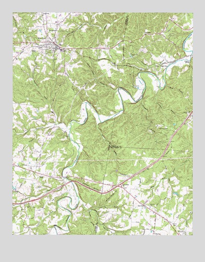
White Bluff, TN USGS Topographic Map
Click on map above to begin viewing in our Map Viewer.

This topographic map contains these locations and features:
Feature Name Type Latitude Longitude GNIS ID View Map
Ballard Spring BranchStreamN36.0170°W87.1867°1276245View Map
Bar School (historical)SchoolN36.0634°W87.1289°1317253View Map
Beaverdam CreekStreamN36.0592°W87.2097°1305042View Map
Becks BranchStreamN36.0206°W87.2389°2036625View Map
Bell TownPopulated PlaceN36.1128°W87.1581°1276948View Map
Bell Town CemeteryCemeteryN36.1187°W87.1564°1647407View Map
Belltown School (historical)SchoolN36.1134°W87.1583°1317246View Map
Bethany Hills CampLocaleN36.1020°W87.1681°1305120View Map
Big Turnbull CreekStreamN36.0209°W87.2033°1277435View Map
Brown CemeteryCemeteryN36.0170°W87.2486°1647700View Map
Buck SpringSpringN36.1145°W87.2208°1278840View Map
Carothers CemeteryCemeteryN36.0326°W87.2072°1324021View Map
Commissioner District 12CivilN36.0646°W87.2281°2464356View Map
Craggie HopePopulated PlaceN36.0926°W87.1500°1281539View Map
Craggie Hope United Methodist ChurchChurchN36.0964°W87.1517°1644885View Map
Dripping Springs Farm AirportAirportN36.0606°W87.2469°2675491View Map
Fairview Fire Department Station 2BuildingN36.0193°W87.1639°2654232View Map
First Baptist ChurchChurchN36.1084°W87.2197°1324080View Map
Fivemile CreekStreamN36.0623°W87.2203°1284348View Map
Garton CemeteryCemeteryN36.0159°W87.2400°1285218View Map
Gin BranchStreamN36.0634°W87.1883°1285441View Map
Goslin BranchStreamN36.0167°W87.2175°1285728View Map
Groves BranchStreamN36.0984°W87.1270°1286360View Map
Herron BranchStreamN36.0142°W87.1950°1287505View Map
Hidebound BranchStreamN36.0595°W87.2339°1287679View Map
Hutton CemeteryCemeteryN36.1051°W87.1917°1324111View Map
Huttons Chapel (historical)ChurchN36.1051°W87.1922°1324113View Map
Huttons Station (historical)LocaleN36.0992°W87.1950°1324114View Map
Indian Camp BranchStreamN36.0812°W87.1767°1288937View Map
Interchange 182CrossingN36.0273°W87.1775°1312516View Map
Interstate WestLocaleN36.0595°W87.1439°1289036View Map
Jackson Furnace (historical)LocaleN36.0592°W87.2389°1324120View Map
Jacksons TempleChurchN36.0328°W87.2283°1306617View Map
Johnson School (historical)SchoolN36.0726°W87.1920°1324125View Map
Kingston Springs Fire Department Station 3BuildingN36.0677°W87.1281°2654132View Map
Little Turnbull CreekStreamN36.0209°W87.2039°1291700View Map
Luther Lake Dam Number ThreeDamN36.0251°W87.2483°1302316View Map
Luther Lake Number ThreeReservoirN36.0251°W87.2483°1302317View Map
Nails CreekStreamN36.0312°W87.2114°1306810View Map
New HopePopulated PlaceN36.0178°W87.1597°1295505View Map
New Hope School (historical)SchoolN36.0162°W87.1550°1321983View Map
Olds CemeteryCemeteryN36.1089°W87.1733°1324162View Map
Opossum School (historical)SchoolN36.0473°W87.2206°1324163View Map
Periwinkle BranchStreamN36.0820°W87.1472°1297182View Map
Pinkerton CemeteryCemeteryN36.0173°W87.1550°1297671View Map
Poplar SpringSpringN36.1037°W87.2365°1298222View Map
Raccoon BranchStreamN36.0145°W87.1958°1298784View Map
Rock BranchStreamN36.0848°W87.1436°1299728View Map
Stillhouse BranchStreamN36.0301°W87.2039°1271399View Map
Sullivan BranchStreamN36.0962°W87.1400°1271746View Map
Talley BranchStreamN36.0770°W87.1600°1272051View Map
Town of White BluffCivilN36.1001°W87.2111°2406875View Map
Turnbull CreekStreamN36.1034°W87.1253°1273058View Map
Turnbull Forge (historical)LocaleN36.0912°W87.1553°1317245View Map
WBLP-AM (Fairview)TowerN36.0081°W87.1439°1639931View Map
White BluffPopulated PlaceN36.1076°W87.2208°1304517View Map
White Bluff CemeteryCemeteryN36.1220°W87.2292°1324256View Map
White Bluff Church of ChristChurchN36.1078°W87.2222°1324257View Map
White Bluff Elementary SchoolSchoolN36.1198°W87.2200°1324259View Map
White Bluff Forge (historical)LocaleN36.0709°W87.2003°1324260View Map
White Bluff Police DepartmentBuildingN36.1082°W87.2249°2766035View Map
White Bluff Post OfficePost OfficeN36.1085°W87.2227°1652320View Map
White Bluff United Methodist ChurchChurchN36.1067°W87.2186°1324261View Map
White Bluff Volunteer Fire DepartmentBuildingN36.1077°W87.2194°2653795View Map
Whites School (historical)SchoolN36.0090°W87.2300°1324262View Map
William James Junior High SchoolSchoolN36.1076°W87.2167°1648388View Map

Note: Coordinates in the location and feature list above are referenced to NAD83 datum.


Copyright (C) 2008-2024 Ryan Niemi / Sunset Dynamics ... All Rights Reserved