TopoQuest Logo
Do you find TopoQuest useful?
Help keep TopoQuest running and adding new maps/features by donating!
Bitcoin:  19c7KJd3qBynnjoSw5npx9KScwjBe4ifkT
Litecoin:  LXs6TkuXGGXo1vDsWCkWVdjQX94eUKd6ui
Home View Maps Find Maps Find Places Resources & Links


Kingston Springs, Tennessee Topographic Map

USGS Map Title: Kingston Springs, TN
USGS Map MRC: 36087A1
DRG (GeoTIFF) Download: o36087a1.tif


Neighboring USGS Topographic Map Quads:


  Harpeth Valley, TN  
36087B2
 

  Lillamay, TN  
36087B1
 

  Scottsboro, TN  
36086B8
 

  White Bluff, TN  
36087A2
 

  Kingston Springs, TN  
36087A1
 

  Bellevue, TN  
36086A8
 

  Craigfield, TN  
35087H2
 

  Fairview, TN  
35087H1
 

  Leipers Fork, TN  
35086H8


Map MRC Location:

N37°
W88°
N37°
W87°
H8 H7 H6 H5 H4 H3 H2 H1
G8 G7 G6 G5 G4 G3 G2 G1
F8 F7 F6 F5 F4 F3 F2 F1
E8 E7 E6 E5 E4 E3 E2 E1
D8 D7 D6 D5 D4 D3 D2 D1
C8 C7 C6 C5 C4 C3 C2 C1
B8 B7 B6 B5 B4 B3 B2 B1
A8 A7 A6 A5 A4 A3 A2 A1
N36°
W88°
N36°
W87°

Kingston Springs, TN USGS 1:24K Topographic Map Preview:
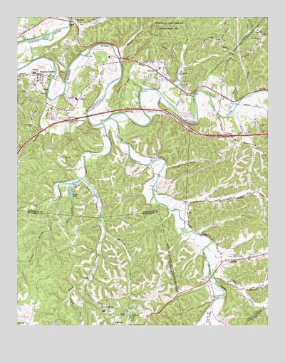
Kingston Springs, TN USGS Topographic Map
Click on map above to begin viewing in our Map Viewer.

This topographic map contains these locations and features:
Feature Name Type Latitude Longitude GNIS ID View Map
Beard ChurchChurchN36.0951°W87.1106°1276639View Map
Beech CreekStreamN36.0862°W87.0178°1276810View Map
Bell HollowValleyN36.0878°W87.0557°1276934View Map
Black Friar FarmLocaleN36.1161°W87.1003°2652504View Map
Blackwood School (historical)SchoolN36.1076°W87.1028°1317259View Map
Boston ChurchChurchN36.0814°W87.0031°1278016View Map
Brush CreekPopulated PlaceN36.0073°W87.0814°1278670View Map
Brush CreekStreamN36.0820°W87.0828°1278680View Map
Buffalo GapGapN36.0856°W87.0931°1644889View Map
Camp MarymountLocaleN36.0034°W87.0672°1279400View Map
Cave SpringsSpringN36.1012°W87.0431°1644888View Map
Cave Springs SchoolSchoolN36.1020°W87.0444°1279971View Map
Commissioner District 6CivilN36.1171°W87.1202°2464516View Map
Cowhorn BranchStreamN36.0920°W87.1061°1281472View Map
Craig LakeReservoirN36.0537°W87.0982°1281548View Map
Craig Lake DamDamN36.0559°W87.0992°1307181View Map
Dog CreekStreamN36.1245°W87.0989°1282590View Map
East Fork CreekStreamN36.0056°W87.0306°1283337View Map
Flatrock BranchStreamN36.0506°W87.1069°1284441View Map
Hannah BranchStreamN36.1117°W87.0769°1286742View Map
Harpeth Hills Memory GardensCemeteryN36.0278°W87.0186°1286921View Map
Harrison BranchStreamN36.0387°W87.0808°1287009View Map
Hatcher HollowValleyN36.0642°W87.0509°1287108View Map
Interchange 188CrossingN36.0837°W87.0981°1310762View Map
Interchange 192CrossingN36.0770°W87.0208°1313444View Map
Jones CreekStreamN36.0473°W87.0500°1313460View Map
Kingston SpringSpringN36.0945°W87.1134°1650781View Map
Kingston SpringsPopulated PlaceN36.1020°W87.1150°1290262View Map
Kingston Springs Division (historical)CensusN36.1101°W87.0956°1648638View Map
Kingston Springs Elementary SchoolSchoolN36.0978°W87.1161°1317258View Map
Kingston Springs Fire Department Station 1BuildingN36.1017°W87.1145°2653846View Map
Kingston Springs Fire Department Station 2BuildingN36.0930°W87.0941°2654262View Map
Kingston Springs Police DepartmentBuildingN36.1017°W87.1146°2765726View Map
Kingston Springs Post OfficePost OfficeN36.0866°W87.1000°1650782View Map
Lever LakeReservoirN36.0045°W87.0708°1291050View Map
Lever Lake DamDamN36.0053°W87.0706°1307177View Map
LintonPopulated PlaceN36.0273°W87.0103°1291350View Map
Linton BranchStreamN36.0148°W87.0131°1291351View Map
Lone Oak ChurchChurchN36.1214°W87.1211°1291850View Map
Middle Tennessee State Veterans CemeteryCemeteryN36.0898°W87.0317°2775154View Map
Mount Pleasant CemeteryCemeteryN36.0812°W87.1175°1294754View Map
Newsom BranchStreamN36.0901°W87.0158°1295702View Map
Old Charlotte ChurchChurchN36.1162°W87.0036°1306859View Map
PegramPopulated PlaceN36.1006°W87.0511°1297122View Map
Pegram Elementary SchoolSchoolN36.1045°W87.0539°1317256View Map
Pegram Post OfficePost OfficeN36.1020°W87.0529°1650780View Map
Pegram Volunteer Fire DepartmentBuildingN36.0961°W87.0430°2653673View Map
Poplar CreekStreamN36.0473°W87.0461°1298185View Map
Price LakeReservoirN36.0578°W87.0957°1298517View Map
Pritchard BranchStreamN36.0192°W87.0278°1298545View Map
ShacklettPopulated PlaceN36.1248°W87.0981°1301143View Map
South Cheatham Junior High SchoolSchoolN36.0923°W87.0956°1317257View Map
South Harpeth CemeteryCemeteryN36.0120°W87.0264°1646430View Map
South Harpeth ChurchChurchN36.0115°W87.0261°1303728View Map
South Harpeth RiverStreamN36.0845°W87.0786°1270894View Map
South Harpeth School (historical)SchoolN36.0651°W87.0592°1317254View Map
Thronton CemeteryCemeteryN36.0659°W87.0581°1272595View Map
Town of Kingston SpringsCivilN36.0848°W87.1043°2405950View Map
Town of PegramCivilN36.1047°W87.0565°2407088View Map
Turner CreekStreamN36.0945°W87.0539°1273080View Map
Wards ChapeklChurchN36.0065°W87.0803°1273803View Map
West Fork Brush CreekStreamN36.0601°W87.0925°1274162View Map
Westview ChapelChurchN36.0920°W87.0939°1304497View Map
Willis BranchStreamN36.0517°W87.0981°1274737View Map

Note: Coordinates in the location and feature list above are referenced to NAD83 datum.


Copyright (C) 2008-2024 Ryan Niemi / Sunset Dynamics ... All Rights Reserved