TopoQuest Logo
Do you find TopoQuest useful?
Help keep TopoQuest running and adding new maps/features by donating!
Bitcoin:  19c7KJd3qBynnjoSw5npx9KScwjBe4ifkT
Litecoin:  LXs6TkuXGGXo1vDsWCkWVdjQX94eUKd6ui
Home View Maps Find Maps Find Places Resources & Links


Weeki Wachee Spring, Florida Topographic Map

USGS Map Title: Weeki Wachee Spring, FL
USGS Map MRC: 28082E5
DRG (GeoTIFF) Download: o28082e5.tif


Neighboring USGS Topographic Map Quads:


  Chassahowitzka Bay, FL  
28082F6
 

  Chassahowitzka, FL  
28082F5
 

  Brooksville NW, FL  
28082F4
 

  Bayport, FL  
28082E6
 

  Weeki Wachee Spring, FL  
28082E5
 

  Brooksville, FL  
28082E4
 

  Aripeka, FL  
28082D6
 

  Port Richey NE, FL  
28082D5
 

  Masaryktown, FL  
28082D4


Map MRC Location:

N29°
W83°
N29°
W82°
H8 H7 H6 H5 H4 H3 H2 H1
G8 G7 G6 G5 G4 G3 G2 G1
F8 F7 F6 F5 F4 F3 F2 F1
E8 E7 E6 E5 E4 E3 E2 E1
D8 D7 D6 D5 D4 D3 D2 D1
C8 C7 C6 C5 C4 C3 C2 C1
B8 B7 B6 B5 B4 B3 B2 B1
A8 A7 A6 A5 A4 A3 A2 A1
N28°
W83°
N28°
W82°

Weeki Wachee Spring, FL USGS 1:24K Topographic Map Preview:
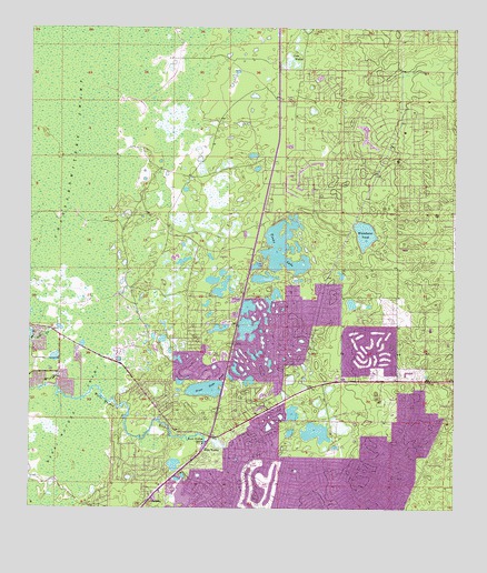
Weeki Wachee Spring, FL USGS Topographic Map
Click on map above to begin viewing in our Map Viewer.

This topographic map contains these locations and features:
Feature Name Type Latitude Longitude GNIS ID View Map
BerkeleyPopulated PlaceN28.5028°W82.5887°278503View Map
Berkeley Preparatory SchoolSchoolN28.6200°W82.5640°302625View Map
City of Weeki WacheeCivilN28.5170°W82.5775°2405701View Map
Coon WallowLakeN28.6158°W82.5471°280772View Map
Grear Hope PondLakeN28.5312°W82.5730°283360View Map
HealthSouth Rehabilitation Hospital of Spring HillHospitalN28.5320°W82.5168°2662462View Map
Hernando County Fire Rescue Station 12BuildingN28.5231°W82.5622°2131707View Map
Hernando County Fire Rescue Station 15BuildingN28.5357°W82.6166°2644300View Map
Hernando High Point Volunteer Fire DepartmentBuildingN28.5418°W82.5252°2644396View Map
High PointPopulated PlaceN28.5469°W82.5247°2407583View Map
High Point Census Designated PlaceCensusN28.5474°W82.5206°2402582View Map
North Weeki Wachee Census Designated PlaceCensusN28.5591°W82.5537°2403357View Map
Oak Hill HospitalHospitalN28.5363°W82.5341°2094920View Map
Saint Andrews SchoolSchoolN28.5547°W82.5007°302650View Map
Salt CreekStreamN28.5447°W82.6240°290423View Map
Spring Hill DivisionCivilN28.5307°W82.5207°1935938View Map
Spring Hill Elementary SchoolSchoolN28.5146°W82.5200°297838View Map
Spring Hill Fire Rescue Station 4BuildingN28.5023°W82.5262°2644280View Map
Tooke LakeLakeN28.5678°W82.5505°292362View Map
Village at Timberpines Shopping CenterLocaleN28.5203°W82.5715°296601View Map
Weeki WacheePopulated PlaceN28.5156°W82.5729°295700View Map
Weeki Wachee Division (historical)CensusN28.5747°W82.5979°1935966View Map
Weeki Wachee Gardens Census Designated PlaceCensusN28.5375°W82.6207°2402992View Map
Weeki Wachee SpringSpringN28.5175°W82.5726°292985View Map
Weekiwachee TowerTowerN28.5333°W82.5079°300935View Map
Whitehurst PondLakeN28.5717°W82.5265°293242View Map

Note: Coordinates in the location and feature list above are referenced to NAD83 datum.


Copyright (C) 2008-2024 Ryan Niemi / Sunset Dynamics ... All Rights Reserved