TopoQuest Logo
Do you find TopoQuest useful?
Help keep TopoQuest running and adding new maps/features by donating!
Bitcoin:  19c7KJd3qBynnjoSw5npx9KScwjBe4ifkT
Litecoin:  LXs6TkuXGGXo1vDsWCkWVdjQX94eUKd6ui
Home View Maps Find Maps Find Places Resources & Links


Watts, Oklahoma Topographic Map

USGS Map Title: Watts, OK
USGS Map MRC: 36094A5
DRG (GeoTIFF) Download: o36094a5.tif


Neighboring USGS Topographic Map Quads:


  Siloam Springs NW, OK  
36094B6
 

  Siloam Springs, AR  
36094B5
 

  Gallatin, AR  
36094B4
 

  Chance, OK  
36094A6
 

  Watts, OK  
36094A5
 

  Rhea, AR  
36094A4
 

  Christie, OK  
35094H6
 

  Westville, OK  
35094H5
 

  Lincoln, AR  
35094H4


Map MRC Location:

N37°
W95°
N37°
W94°
H8 H7 H6 H5 H4 H3 H2 H1
G8 G7 G6 G5 G4 G3 G2 G1
F8 F7 F6 F5 F4 F3 F2 F1
E8 E7 E6 E5 E4 E3 E2 E1
D8 D7 D6 D5 D4 D3 D2 D1
C8 C7 C6 C5 C4 C3 C2 C1
B8 B7 B6 B5 B4 B3 B2 B1
A8 A7 A6 A5 A4 A3 A2 A1
N36°
W95°
N36°
W94°

Watts, OK USGS 1:24K Topographic Map Preview:
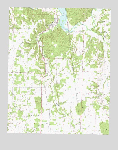
Watts, OK USGS Topographic Map
Click on map above to begin viewing in our Map Viewer.

This topographic map contains these locations and features:
Feature Name Type Latitude Longitude GNIS ID View Map
BallardPopulated PlaceN36.0945°W94.5894°1089826View Map
Ballard ChurchChurchN36.1042°W94.5930°1089828View Map
Ballard CreekStreamN36.1104°W94.5636°46063View Map
Baptist Mission CemeterCemeteryN36.0353°W94.5833°2712388View Map
Bates MountainSummitN36.0242°W94.5361°76244View Map
Bell MountainSummitN36.0034°W94.5027°46358View Map
Brady CemeteryCemeteryN36.1020°W94.5349°46907View Map
CincinnatiPopulated PlaceN36.0373°W94.5111°47789View Map
Cincinnati CreekStreamN36.1037°W94.5274°71153View Map
Cincinnati United Methodist ChurchChurchN36.0334°W94.5099°65310View Map
Cincinnati Volunteer Fire Station 2BuildingN36.0383°W94.5088°2116273View Map
Colony Community ChurchChurchN36.0823°W94.5338°47936View Map
Fairview School (historical)SchoolN36.0823°W94.5338°65331View Map
Faith ChapelChurchN36.0859°W94.6099°1092743View Map
Fishers FordCrossingN36.1229°W94.5161°75513View Map
Full Gospel ChurchChurchN36.1004°W94.5855°1093079View Map
Goforth BridgeBridgeN36.1090°W94.5349°75533View Map
Goforth FordCrossingN36.1090°W94.5349°75534View Map
Harold CemeteryCemeteryN36.0740°W94.5072°49877View Map
Lacie CemeteryCemeteryN36.0336°W94.6008°2712397View Map
Mission ChurchChurchN36.0354°W94.5838°1095446View Map
Mission MountainSummitN36.0306°W94.5872°1095451View Map
Nicodemus Community ChurchChurchN36.1123°W94.5080°52774View Map
Nicodemus School (historical)SchoolN36.1123°W94.5080°75931View Map
Old Union CemeteryCemeteryN36.0298°W94.5049°53034View Map
Phillips CemeteryCemeteryN36.0026°W94.5583°1096599View Map
Reverend Jesse Bushyhead GraveCemeteryN36.0358°W94.5828°2712404View Map
Sixkiller CemeteryCemeteryN36.0756°W94.6126°1098074View Map
Spring Harbor LandingLocaleN36.1134°W94.5538°75506View Map
Town of WattsCivilN36.1073°W94.5718°2413456View Map
Township of BallardCivilN36.0917°W94.6002°1824594View Map
WattsPopulated PlaceN36.1092°W94.5702°1099434View Map
Watts CemeteryCemeteryN36.1135°W94.5778°1099435View Map
Watts CommunityCivilN36.0534°W94.5629°2631196View Map
Watts Community Census Designated PlaceCensusN36.0534°W94.5629°2409535View Map
Watts Elementary SchoolSchoolN36.1106°W94.5719°2713032View Map
Watts Fire DepartmentBuildingN36.1068°W94.5727°2657110View Map
Watts High SchoolSchoolN36.1103°W94.5714°1790502View Map
Watts Police DepartmentBuildingN36.1064°W94.5749°2757753View Map
Weddington CreekStreamN36.0931°W94.5058°78713View Map
Westville CemeteryCemeteryN36.0090°W94.5755°1099642View Map

Note: Coordinates in the location and feature list above are referenced to NAD83 datum.


Copyright (C) 2008-2024 Ryan Niemi / Sunset Dynamics ... All Rights Reserved