TopoQuest Logo
Do you find TopoQuest useful?
Help keep TopoQuest running and adding new maps/features by donating!
Bitcoin:  19c7KJd3qBynnjoSw5npx9KScwjBe4ifkT
Litecoin:  LXs6TkuXGGXo1vDsWCkWVdjQX94eUKd6ui
Home View Maps Find Maps Find Places Resources & Links


Siloam Springs NW, Oklahoma Topographic Map

USGS Map Title: Siloam Springs NW, OK
USGS Map MRC: 36094B6
DRG (GeoTIFF) Download: o36094b6.tif


Neighboring USGS Topographic Map Quads:


  Lake Eucha East, OK  
36094C7
 

  Colcord, OK  
36094C6
 

  Cherokee City, AR  
36094C5
 

  Kansas, OK  
36094B7
 

  Siloam Springs NW, OK  
36094B6
 

  Siloam Springs, AR  
36094B5
 

  Chewey, OK  
36094A7
 

  Chance, OK  
36094A6
 

  Watts, OK  
36094A5


Map MRC Location:

N37°
W95°
N37°
W94°
H8 H7 H6 H5 H4 H3 H2 H1
G8 G7 G6 G5 G4 G3 G2 G1
F8 F7 F6 F5 F4 F3 F2 F1
E8 E7 E6 E5 E4 E3 E2 E1
D8 D7 D6 D5 D4 D3 D2 D1
C8 C7 C6 C5 C4 C3 C2 C1
B8 B7 B6 B5 B4 B3 B2 B1
A8 A7 A6 A5 A4 A3 A2 A1
N36°
W95°
N36°
W94°

Siloam Springs NW, OK USGS 1:24K Topographic Map Preview:
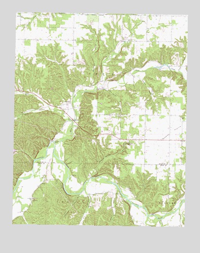
Siloam Springs NW, OK USGS Topographic Map
Click on map above to begin viewing in our Map Viewer.

This topographic map contains these locations and features:
Feature Name Type Latitude Longitude GNIS ID View Map
Allen CemeteryCemeteryN36.1897°W94.6503°2724211View Map
BeckwithPopulated PlaceN36.1970°W94.7099°1100199View Map
Blue Spring BranchStreamN36.2045°W94.6833°1090295View Map
Calunchety HollowValleyN36.2076°W94.6938°1090812View Map
Calvary Baptist ChurchChurchN36.1756°W94.6263°1090822View Map
Colcord DivisionCivilN36.2479°W94.6751°1937676View Map
Crazy CreekStreamN36.2167°W94.6319°48152View Map
Crazy CreekStreamN36.2167°W94.6319°1091808View Map
Crittenden CemeteryCemeteryN36.1401°W94.7363°1091828View Map
Dripping SpringsCivilN36.1711°W94.6851°2631099View Map
Dripping SpringsPopulated PlaceN36.1740°W94.6722°1853462View Map
Dripping SpringsSpringN36.1740°W94.6680°1092195View Map
Dripping Springs BranchStreamN36.1529°W94.6938°1092196View Map
Dripping Springs Census Designated PlaceCensusN36.1711°W94.6851°2408689View Map
Fidlers BendBendN36.1734°W94.7222°1092800View Map
Fivemile HollowValleyN36.1864°W94.7078°1092863View Map
FlintPopulated PlaceN36.1873°W94.7080°1100416View Map
Flint CreekStreamN36.1743°W94.7213°1092900View Map
Flint CreekCivilN36.1764°W94.7438°2631108View Map
Flint CreekPopulated PlaceN36.1773°W94.7408°1853468View Map
Flint CreekStreamN36.1743°W94.7213°76939View Map
Flint Creek Census Designated PlaceCensusN36.1764°W94.7438°2408215View Map
Hazelnut HollowValleyN36.2144°W94.6649°1093627View Map
Illinois River ChurchChurchN36.1393°W94.7355°1094044View Map
Johnson CemeteryCemeteryN36.1750°W94.6258°2723923View Map
Kill HollowValleyN36.1432°W94.6951°1094375View Map
Moseley Elementary SchoolSchoolN36.1891°W94.6291°1095538View Map
Moseley PrairieFlatN36.1779°W94.6386°1095537View Map
Rock BranchStreamN36.1470°W94.6738°1097271View Map
Tahlequah HollowValleyN36.1431°W94.7030°1098724View Map
Tate Parris BranchStreamN36.1292°W94.6438°1098761View Map
Township 2CivilN36.2167°W94.6919°1824561View Map
Union ChurchChurchN36.2212°W94.6452°1099161View Map
West Siloam Springs Volunteer Fire DepartmentBuildingN36.1779°W94.6369°2657412View Map

Note: Coordinates in the location and feature list above are referenced to NAD83 datum.


Copyright (C) 2008-2024 Ryan Niemi / Sunset Dynamics ... All Rights Reserved