TopoQuest Logo
Do you find TopoQuest useful?
Help keep TopoQuest running and adding new maps/features by donating!
Bitcoin:  19c7KJd3qBynnjoSw5npx9KScwjBe4ifkT
Litecoin:  LXs6TkuXGGXo1vDsWCkWVdjQX94eUKd6ui
Home View Maps Find Maps Find Places Resources & Links


Walnut Ridge, Arkansas Topographic Map

USGS Map Title: Walnut Ridge, AR
USGS Map MRC: 36090A8
DRG (GeoTIFF) Download: o36090a8.tif


Neighboring USGS Topographic Map Quads:


  Noland, AR  
36091B1
 

  Manson, AR  
36090B8
 

  O'Kean, AR  
36090B7
 

  Black Rock, AR  
36091A1
 

  Walnut Ridge, AR  
36090A8
 

  Walnut Ridge SE, AR  
36090A7
 

  Alicia, AR  
35091H1
 

  Podo Creek, AR  
35090H8
 

  Bono, AR  
35090H7


Map MRC Location:

N37°
W91°
N37°
W90°
H8 H7 H6 H5 H4 H3 H2 H1
G8 G7 G6 G5 G4 G3 G2 G1
F8 F7 F6 F5 F4 F3 F2 F1
E8 E7 E6 E5 E4 E3 E2 E1
D8 D7 D6 D5 D4 D3 D2 D1
C8 C7 C6 C5 C4 C3 C2 C1
B8 B7 B6 B5 B4 B3 B2 B1
A8 A7 A6 A5 A4 A3 A2 A1
N36°
W91°
N36°
W90°

Walnut Ridge, AR USGS 1:24K Topographic Map Preview:
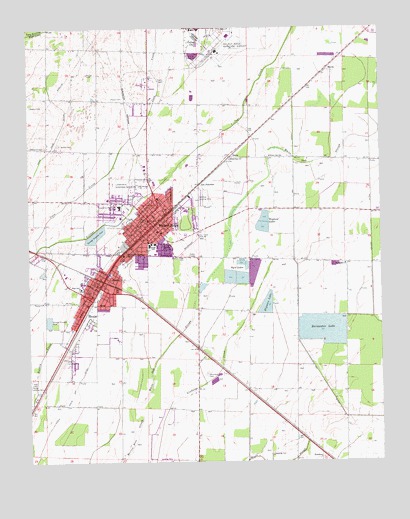
Walnut Ridge, AR USGS Topographic Map
Click on map above to begin viewing in our Map Viewer.

This topographic map contains these locations and features:
Feature Name Type Latitude Longitude GNIS ID View Map
Aa JunctionPopulated PlaceN36.0798°W90.9398°56904View Map
Adams CemeteryCemeteryN36.1028°W90.9990°45784View Map
Arkansas Excellent TransportBuildingN36.0656°W90.9527°2119182View Map
Austin CemeteryCemeteryN36.0917°W90.9890°45983View Map
Byrd LakesReservoirN36.0515°W90.9223°76482View Map
Callahan Landing Strip (historical)AirportN36.0765°W90.9393°64021View Map
City of HoxieCivilN36.0365°W90.9736°2404737View Map
City of Walnut RidgeCivilN36.0843°W90.9466°2405666View Map
Clark Shopping CenterLocaleN36.0759°W90.9540°61553View Map
Coon CreekStreamN36.0612°W90.9976°47999View Map
DicusPopulated PlaceN36.0884°W90.9279°76795View Map
Digman LakeReservoirN36.0459°W90.9140°76797View Map
Evergreen ChurchChurchN36.0570°W90.8876°48950View Map
Evergreen School (historical)SchoolN36.0570°W90.8873°64022View Map
Fry DitchCanalN36.0220°W90.8954°49280View Map
HoxiePopulated PlaceN36.0503°W90.9751°57952View Map
Hoxie Elementary SchoolSchoolN36.0517°W90.9820°61573View Map
Hoxie High SchoolSchoolN36.0508°W90.9814°61574View Map
Hoxie JunctionLocaleN36.0242°W90.9929°64025View Map
Hoxie Police DepartmentBuildingN36.0487°W90.9805°2118582View Map
Hoxie Volunteer Fire DepartmentBuildingN36.0487°W90.9806°2116606View Map
Johnson Landing Strip (historical)AirportN36.0301°W90.9871°64026View Map
Joplin School (historical)SchoolN36.1192°W90.9829°64027View Map
Kellow DitchCanalN36.0687°W90.8782°50792View Map
KHOX-FM (Hoxie)TowerN36.0401°W90.9865°85199View Map
KRLW-AM (Walnut Ridge)TowerN36.0662°W90.9401°85148View Map
KRLW-FM (Walnut Ridge)TowerN36.0662°W90.9401°85250View Map
Lane School (historical)SchoolN36.0887°W90.9579°64028View Map
Lawrence County CourthouseBuildingN36.0698°W90.9585°61577View Map
Lawrence County LibraryBuildingN36.0681°W90.9576°77326View Map
Lawrence County Sheriff's OfficeBuildingN36.0699°W90.9585°2118584View Map
Lawrence Memorial HeliportAirportN36.0737°W90.9685°83855View Map
Lawrence Memorial HospitalHospitalN36.0737°W90.9678°51007View Map
Lawrence Memorial HospitalHospitalN36.0738°W90.9678°2092855View Map
Lawrence Memorial ParkCemeteryN36.0803°W90.9704°77457View Map
Little White Oak DitchCanalN36.0192°W90.9854°51339View Map
Main Street Church of ChristChurchN36.0662°W90.9529°77327View Map
Manning CemeteryCemeteryN36.0020°W90.9146°51645View Map
Medic One Walnut RidgeBuildingN36.0713°W90.9598°2739647View Map
MurtaPopulated PlaceN36.1134°W90.8937°58233View Map
Old School (historical)SchoolN36.0256°W90.9368°64033View Map
Old Walnut Ridge School (historical)SchoolN36.0901°W90.9901°64034View Map
Olympus Post Office (historical)Post OfficeN36.0678°W90.9618°85277View Map
Pierce CemeteryCemeteryN36.1048°W90.9665°53353View Map
PondersPopulated PlaceN36.0009°W90.8971°58410View Map
Rainwater LakeReservoirN36.0351°W90.9046°77303View Map
Rock SpurLocaleN36.0328°W90.9404°64036View Map
Sedgwick Volunteer Fire DepartmentBuildingN36.0017°W90.8963°2117105View Map
Sheltering Arms Nursing HomeBuildingN36.0709°W90.9554°61575View Map
Stewart ParkParkN36.0701°W90.9446°61576View Map
Township of BoasCivilN36.0252°W90.9800°66786View Map
Township of CampbellCivilN36.0967°W90.9375°66788View Map
Union School (historical)SchoolN36.0003°W90.8973°64037View Map
Walnut RidgePopulated PlaceN36.0684°W90.9560°78686View Map
Walnut Ridge CemeteryCemeteryN36.0590°W90.9448°56019View Map
Walnut Ridge City HallBuildingN36.0673°W90.9551°61578View Map
Walnut Ridge Elementary SchoolSchoolN36.0629°W90.9551°61580View Map
Walnut Ridge Fire Department Station 1BuildingN36.0668°W90.9547°2117269View Map
Walnut Ridge High SchoolSchoolN36.0624°W90.9574°61579View Map
Walnut Ridge Middle SchoolSchoolN36.0612°W90.9546°61581View Map
Walnut Ridge Police DepartmentBuildingN36.0676°W90.9557°2118585View Map
Walnut Ridge Post OfficePost OfficeN36.0684°W90.9579°84653View Map
Wayland LakesLakeN36.0692°W90.9167°2786273View Map
Westphal CemeteryCemeteryN36.0912°W90.9996°56208View Map
Whitaker School (historical)SchoolN36.0259°W90.9407°64038View Map
White Oak ChurchChurchN36.0870°W90.9285°56268View Map
White Oak SchoolSchoolN36.0881°W90.9143°56296View Map
Whittaker CemeteryCemeteryN36.0256°W90.9376°78769View Map

Note: Coordinates in the location and feature list above are referenced to NAD83 datum.


Copyright (C) 2008-2024 Ryan Niemi / Sunset Dynamics ... All Rights Reserved