TopoQuest Logo
Do you find TopoQuest useful?
Help keep TopoQuest running and adding new maps/features by donating!
Bitcoin:  19c7KJd3qBynnjoSw5npx9KScwjBe4ifkT
Litecoin:  LXs6TkuXGGXo1vDsWCkWVdjQX94eUKd6ui
Home View Maps Find Maps Find Places Resources & Links


Waldron, Arkansas Topographic Map

USGS Map Title: Waldron, AR
USGS Map MRC: 34094H1
DRG (GeoTIFF) Download: o34094h1.tif


Neighboring USGS Topographic Map Quads:


  Abbott, AR  
35094A2
 

  Ione, AR  
35094A1
 

  Golden City, AR  
35093A8
 

  Hon, AR  
34094H2
 

  Waldron, AR  
34094H1
 

  Bee Mountain, AR  
34093H8
 

  Peanut Mountain, AR  
34094G2
 

  Boles, AR  
34094G1
 

  Parks, AR  
34093G8


Map MRC Location:

N35°
W95°
N35°
W94°
H8 H7 H6 H5 H4 H3 H2 H1
G8 G7 G6 G5 G4 G3 G2 G1
F8 F7 F6 F5 F4 F3 F2 F1
E8 E7 E6 E5 E4 E3 E2 E1
D8 D7 D6 D5 D4 D3 D2 D1
C8 C7 C6 C5 C4 C3 C2 C1
B8 B7 B6 B5 B4 B3 B2 B1
A8 A7 A6 A5 A4 A3 A2 A1
N34°
W95°
N34°
W94°

Waldron, AR USGS 1:24K Topographic Map Preview:
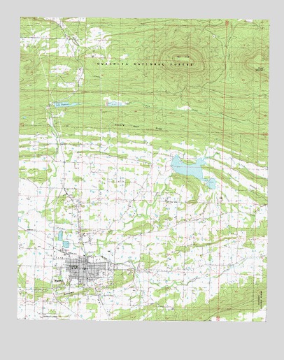
Waldron, AR USGS Topographic Map
Click on map above to begin viewing in our Map Viewer.

This topographic map contains these locations and features:
Feature Name Type Latitude Longitude GNIS ID View Map
AndersonPopulated PlaceN34.9123°W94.1216°76169View Map
Birdsview CemeteryCemeteryN34.9293°W94.0633°66265View Map
Birdsview United Methodist ChurchChurchN34.9298°W94.0627°76354View Map
Blythes MuseumBuildingN34.9134°W94.0941°66268View Map
Bohnstein HillSummitN34.8884°W94.0802°70758View Map
Center Point SchoolSchoolN34.9329°W94.0772°71101View Map
City of WaldronCivilN34.9007°W94.0942°2405661View Map
Clear CreekStreamN34.9376°W94.1060°71161View Map
Colburn Spring (historical)Populated PlaceN34.9904°W94.0147°66280View Map
Duncan CemeteryCemeteryN34.8887°W94.0977°71472View Map
East Fork Poteau RiverStreamN34.9029°W94.0869°71509View Map
Fairs Chapel Methodist ChurchChurchN34.9029°W94.0108°76912View Map
First Baptist ChurchChurchN34.8959°W94.0916°66285View Map
Green RidgePopulated PlaceN34.9237°W94.0238°66290View Map
Haw Creek ChurchChurchN34.8870°W94.1249°71946View Map
Lake WaldronReservoirN34.9639°W94.1025°74353View Map
Lake Waldron DamDamN34.9634°W94.1102°80544View Map
Lone ElmPopulated PlaceN34.9418°W94.0272°66300View Map
Lone Elm SchoolSchoolN34.9423°W94.0272°72455View Map
Mercy Hospital WaldronHospitalN34.8945°W94.1060°66308View Map
Mount Pleasant CemeteryCemeteryN34.9240°W94.0246°66313View Map
Mount Pleasant Methodist ChurchChurchN34.9232°W94.0235°77738View Map
Mud CreekStreamN34.9229°W94.1102°72801View Map
Old Salem CemeteryCemeteryN34.9315°W94.0927°72937View Map
Pilot KnobSummitN34.9834°W94.0463°73077View Map
Pilot Prairie CemeteryCemeteryN34.9045°W94.0274°66322View Map
Pilot Prairie Presbyterian ChurchChurchN34.9048°W94.0277°78003View Map
Pleasant HillPopulated PlaceN34.9045°W94.1238°66324View Map
Pleasant Hill Primitive Baptist ChurchChurchN34.9043°W94.1244°66326View Map
Pleasant Hill SchoolSchoolN34.9048°W94.1244°73132View Map
Pleasant ValleyPopulated PlaceN34.8984°W94.0169°66327View Map
Poteau Ouachita National Forest Work CenterLocaleN34.8945°W94.0691°66328View Map
Poteau Ranger StationLocaleN34.8865°W94.1074°74439View Map
Poteau River Site Five LakeReservoirN34.9368°W94.0485°80552View Map
Poteau River Watershed Site Five DamDamN34.9368°W94.0485°80551View Map
Poteau River Watershed Site Four DamDamN34.9318°W94.0285°80555View Map
Poteau River Watershed Site Six DamDamN34.9634°W94.0769°80546View Map
Poteau Work CenterLocaleN34.8943°W94.0694°74440View Map
Prairie CreekStreamN34.9362°W94.0377°73195View Map
Ragsdale ArenaBuildingN34.9051°W94.0905°66329View Map
Round MountainSummitN34.9790°W94.0013°73414View Map
Scott County CourthouseBuildingN34.8993°W94.0916°66330View Map
Scott County LibraryBuildingN34.8998°W94.0930°66331View Map
Scott County Sheriff's OfficeBuildingN34.9009°W94.0928°2118923View Map
Self BranchStreamN34.9412°W94.0327°70391View Map
Sodie Davidson ParkParkN34.8804°W94.0802°66337View Map
Southwest Emergency Medical Service WaldronBuildingN34.8945°W94.1055°2119098View Map
Square Rock CemeteryCemeteryN34.9459°W94.1024°66338View Map
Square Rock CreekStreamN34.9198°W94.1152°73679View Map
Square Rock Methodist ChurchChurchN34.9473°W94.1019°78442View Map
Square Rock RidgeRidgeN34.9609°W94.0713°73680View Map
Township of HickmanCivilN34.9077°W94.0870°69063View Map
Truman Baker ParkParkN34.8815°W94.1038°66342View Map
WaldronPopulated PlaceN34.8984°W94.0908°78668View Map
Waldron City HallBuildingN34.8982°W94.0910°66345View Map
Waldron City Volunteer Fire DepartmentBuildingN34.8973°W94.0904°2117261View Map
Waldron Elementary SchoolSchoolN34.9020°W94.1128°66346View Map
Waldron High SchoolSchoolN34.9004°W94.1147°66347View Map
Waldron LakeReservoirN34.9373°W94.0480°74352View Map
Waldron Middle SchoolSchoolN34.9036°W94.1138°66348View Map
Waldron Municipal AirportAirportN34.8767°W94.1109°83853View Map
Waldron Police DepartmentBuildingN34.8979°W94.0919°2118965View Map
Waldron Post OfficePost OfficeN34.8979°W94.0919°84377View Map
Waldron Rural Volunteer Fire Department Station 1BuildingN34.9006°W94.0868°2117262View Map
Waldron Rural Volunteer Fire Department Station 2BuildingN34.9270°W94.0145°2117263View Map

Note: Coordinates in the location and feature list above are referenced to NAD83 datum.


Copyright (C) 2008-2024 Ryan Niemi / Sunset Dynamics ... All Rights Reserved