TopoQuest Logo
Do you find TopoQuest useful?
Help keep TopoQuest running and adding new maps/features by donating!
Bitcoin:  19c7KJd3qBynnjoSw5npx9KScwjBe4ifkT
Litecoin:  LXs6TkuXGGXo1vDsWCkWVdjQX94eUKd6ui
Home View Maps Find Maps Find Places Resources & Links


Van Etten, New York Topographic Map

USGS Map Title: Van Etten, NY
USGS Map MRC: 42076B5
DRG (GeoTIFF) Download: o42076b5.tif


Neighboring USGS Topographic Map Quads:


  Alpine, NY  
42076C6
 

  West Danby, NY  
42076C5
 

  Willseyville, NY  
42076C4
 

  Erin, NY  
42076B6
 

  Van Etten, NY  
42076B5
 

  Spencer, NY  
42076B4
 

  Wellsburg, NY  
42076A6
 

  Waverly, NY  
42076A5
 

  Barton, NY  
42076A4


Map MRC Location:

N43°
W77°
N43°
W76°
H8 H7 H6 H5 H4 H3 H2 H1
G8 G7 G6 G5 G4 G3 G2 G1
F8 F7 F6 F5 F4 F3 F2 F1
E8 E7 E6 E5 E4 E3 E2 E1
D8 D7 D6 D5 D4 D3 D2 D1
C8 C7 C6 C5 C4 C3 C2 C1
B8 B7 B6 B5 B4 B3 B2 B1
A8 A7 A6 A5 A4 A3 A2 A1
N42°
W77°
N42°
W76°

Van Etten, NY USGS 1:24K Topographic Map Preview:
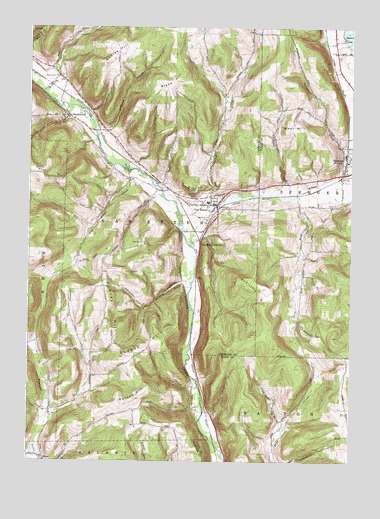
Van Etten, NY USGS Topographic Map
Click on map above to begin viewing in our Map Viewer.

This topographic map contains these locations and features:
Feature Name Type Latitude Longitude GNIS ID View Map
Assembly of God ChurchChurchN42.2377°W76.6149°2597497View Map
Baker CreekStreamN42.2090°W76.5855°942828View Map
Barnes HillSummitN42.1426°W76.5869°943047View Map
Blake HillSummitN42.2373°W76.5661°944214View Map
Burheight CreekStreamN42.2023°W76.5202°945211View Map
Canfield Memorial CemeteryCemeteryN42.2018°W76.5591°945771View Map
Cayuta Creek BridgeBridgeN42.2201°W76.5992°2598545View Map
Cooper HillSummitN42.1554°W76.5894°947390View Map
Darling CreekStreamN42.1751°W76.5619°948037View Map
Doolittle HillSummitN42.1776°W76.5433°948578View Map
Jenkins CemeteryCemeteryN42.1794°W76.5960°2514410View Map
Johnson CreekStreamN42.2187°W76.5988°954113View Map
Langford CreekStreamN42.1959°W76.5663°955037View Map
McDuffy CreekStreamN42.2312°W76.6199°956760View Map
Mount Hope CemeteryCemeteryN42.2029°W76.5597°957839View Map
Nobles HillSummitN42.2395°W76.5963°958637View Map
Rumsey CemeteryCemeteryN42.1583°W76.5922°2514411View Map
Rumsey HillSummitN42.1626°W76.5924°963077View Map
Saint Pius X ChurchChurchN42.1992°W76.5606°2597529View Map
Spencer LakeLakeN42.2475°W76.5003°965985View Map
Spencer-Van Etten Elementary SchoolSchoolN42.1997°W76.5556°2507542View Map
Spencer-Van Etten High SchoolSchoolN42.2039°W76.5222°2507539View Map
SwartwoodPopulated PlaceN42.2245°W76.6097°966902View Map
Swartwood CemeteryCemeteryN42.2360°W76.6130°966903View Map
Town of Van EttenCivilN42.2120°W76.5789°979577View Map
Van EttenPopulated PlaceN42.1987°W76.5524°968412View Map
Van Etten Community United ChurchChurchN42.1992°W76.5534°2597534View Map
Van Etten JunctionPopulated PlaceN42.1887°W76.5588°968414View Map
Van Etten Volunteer Fire DepartmentBuildingN42.1986°W76.5512°2735112View Map
Village of Van EttenCivilN42.1975°W76.5542°2391183View Map
West HillSummitN42.2209°W76.5194°969254View Map
Westbrook CemeteryCemeteryN42.1951°W76.5555°970892View Map

Note: Coordinates in the location and feature list above are referenced to NAD83 datum.


Copyright (C) 2008-2024 Ryan Niemi / Sunset Dynamics ... All Rights Reserved