TopoQuest Logo
Do you find TopoQuest useful?
Help keep TopoQuest running and adding new maps/features by donating!
Bitcoin:  19c7KJd3qBynnjoSw5npx9KScwjBe4ifkT
Litecoin:  LXs6TkuXGGXo1vDsWCkWVdjQX94eUKd6ui
Home View Maps Find Maps Find Places Resources & Links


Upton, Kentucky Topographic Map

USGS Map Title: Upton, KY
USGS Map MRC: 37085D8
DRG (GeoTIFF) Download: o37085d8.tif


Neighboring USGS Topographic Map Quads:


  Summit, KY  
37086E1
 

  Sonora, KY  
37085E8
 

  Tonieville, KY  
37085E7
 

  Millerstown, KY  
37086D1
 

  Upton, KY  
37085D8
 

  Hammonville, KY  
37085D7
 

  Cub Run, KY  
37086C1
 

  Munfordville, KY  
37085C8
 

  Canmer, KY  
37085C7


Map MRC Location:

N38°
W86°
N38°
W85°
H8 H7 H6 H5 H4 H3 H2 H1
G8 G7 G6 G5 G4 G3 G2 G1
F8 F7 F6 F5 F4 F3 F2 F1
E8 E7 E6 E5 E4 E3 E2 E1
D8 D7 D6 D5 D4 D3 D2 D1
C8 C7 C6 C5 C4 C3 C2 C1
B8 B7 B6 B5 B4 B3 B2 B1
A8 A7 A6 A5 A4 A3 A2 A1
N37°
W86°
N37°
W85°

Upton, KY USGS 1:24K Topographic Map Preview:
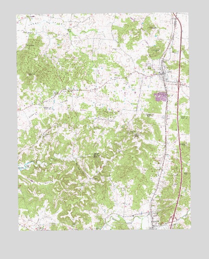
Upton, KY USGS Topographic Map
Click on map above to begin viewing in our Map Viewer.

This topographic map contains these locations and features:
Feature Name Type Latitude Longitude GNIS ID View Map
Bethel ChurchChurchN37.4387°W85.8919°486975View Map
Big Springs CemeteryCemeteryN37.4695°W85.9058°487274View Map
Blue Hole SpringSpringN37.4187°W85.9446°487522View Map
Blue Spring BranchStreamN37.4151°W85.9583°487545View Map
BonnievillePopulated PlaceN37.3787°W85.9030°487671View Map
Bonnieville DivisionCivilN37.3903°W85.9456°1936880View Map
Bonnieville Volunteer Fire DepartmentBuildingN37.3778°W85.9026°2637008View Map
Brackett CemeteryCemeteryN37.4517°W85.9575°487784View Map
Brashear CemeteryCemeteryN37.4789°W85.9269°487839View Map
Burnt KnobSummitN37.4070°W85.8766°488461View Map
Campground CemeteryCemeteryN37.3753°W85.9416°488746View Map
City of BonnievilleCivilN37.3776°W85.9011°2403894View Map
City of UptonCivilN37.4626°W85.8990°2405631View Map
Falling SpringsSpringN37.4302°W85.9137°491956View Map
Falling Springs United Baptist ChurchChurchN37.4309°W85.9155°491958View Map
Flint HillPopulated PlaceN37.4984°W85.9905°508014View Map
Gardner KnobSummitN37.4237°W85.8789°492701View Map
Indian Ambush Historical MarkerParkN37.3787°W85.9026°2744422View Map
Jacobs KnobSummitN37.4914°W85.9021°495081View Map
Jim Moore HillSummitN37.4773°W85.8975°495269View Map
Leesville CemeteryCemeteryN37.4392°W85.8919°496187View Map
Lone StarPopulated PlaceN37.4048°W85.9466°508497View Map
Lucas Grove ChurchChurchN37.4556°W85.9597°497329View Map
MelrosePopulated PlaceN37.4892°W85.9922°508588View Map
Peter Cave HillSummitN37.4634°W85.9908°500466View Map
Pleasant Hill ChurchChurchN37.4297°W85.9816°500867View Map
Priddy HollowValleyN37.4082°W85.9990°501340View Map
Riders MillPopulated PlaceN37.4106°W85.9991°508935View Map
Roaring SpringSpringN37.4535°W85.9721°502042View Map
Round Stone SpringSpringN37.4177°W85.9451°502413View Map
Sandy CreekStreamN37.4962°W85.9891°502977View Map
Seven CornersPopulated PlaceN37.4820°W85.9927°509033View Map
Stoney Point ChurchChurchN37.4381°W85.9336°504494View Map
UptonPopulated PlaceN37.4651°W85.8933°505924View Map
Upton CemeteryCemeteryN37.4595°W85.9211°505925View Map
Upton Fire DepartmentBuildingN37.4635°W85.8939°2636878View Map
VentoPopulated PlaceN37.4181°W85.8930°509280View Map
Zion ChurchChurchN37.4895°W85.9619°507283View Map

Note: Coordinates in the location and feature list above are referenced to NAD83 datum.


Copyright (C) 2008-2024 Ryan Niemi / Sunset Dynamics ... All Rights Reserved