TopoQuest Logo
Do you find TopoQuest useful?
Help keep TopoQuest running and adding new maps/features by donating!
Bitcoin:  19c7KJd3qBynnjoSw5npx9KScwjBe4ifkT
Litecoin:  LXs6TkuXGGXo1vDsWCkWVdjQX94eUKd6ui
Home View Maps Find Maps Find Places Resources & Links


Union City, Indiana Topographic Map

USGS Map Title: Union City, IN
USGS Map MRC: 40084B7
DRG (GeoTIFF) Download: o40084b7.tif


Neighboring USGS Topographic Map Quads:


  Deerfield, IN  
40084C8
 

  Cosmos, OH  
40084C7
 

  Rossburg, OH  
40084C6
 

  Winchester, IN  
40084B8
 

  Union City, IN  
40084B7
 

  Ansonia, OH  
40084B6
 

  Lynn, IN  
40084A8
 

  Spartanburg, IN  
40084A7
 

  Greenville West, OH  
40084A6


Map MRC Location:

N41°
W85°
N41°
W84°
H8 H7 H6 H5 H4 H3 H2 H1
G8 G7 G6 G5 G4 G3 G2 G1
F8 F7 F6 F5 F4 F3 F2 F1
E8 E7 E6 E5 E4 E3 E2 E1
D8 D7 D6 D5 D4 D3 D2 D1
C8 C7 C6 C5 C4 C3 C2 C1
B8 B7 B6 B5 B4 B3 B2 B1
A8 A7 A6 A5 A4 A3 A2 A1
N40°
W85°
N40°
W84°

Union City, IN USGS 1:24K Topographic Map Preview:
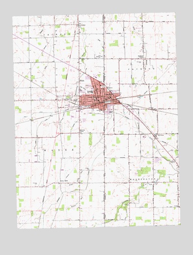
Union City, IN USGS Topographic Map
Click on map above to begin viewing in our Map Viewer.

This topographic map contains these locations and features:
Feature Name Type Latitude Longitude GNIS ID View Map
Bennett School (historical)SchoolN40.2231°W84.7847°1055496View Map
Bickel School (historical)SchoolN40.1653°W84.7888°1055497View Map
Brick Memorial Park CemeteryCemeteryN40.2250°W84.8058°431509View Map
Buckhorn CornerPopulated PlaceN40.2231°W84.7752°1062673View Map
Calvary ChurchChurchN40.2050°W84.8130°431984View Map
City DrainStreamN40.2070°W84.8225°432535View Map
City of Union CityCivilN40.1995°W84.8206°2397087View Map
Double D Wind FarmLocaleN40.1836°W84.7628°2710846View Map
Elson DitchCanalN40.1312°W84.7911°1040174View Map
Evangelical United Methodist ChurchChurchN40.2009°W84.8030°1807563View Map
Flory School (historical)SchoolN40.1631°W84.7538°1055509View Map
Fresh Aire FarmsLocaleN40.1533°W84.7578°2710849View Map
Haysville CornerPopulated PlaceN40.1806°W84.8258°435929View Map
Hill GrovePopulated PlaceN40.1775°W84.7683°1056331View Map
Hillgrove CemeteryCemeteryN40.1792°W84.7708°1806169View Map
Hillgrove Federated ChurchChurchN40.1787°W84.7661°1807564View Map
Hillgrove Post Office (historical)Post OfficeN40.1778°W84.7680°1968178View Map
Hoover CemeteryCemeteryN40.1587°W84.8194°436420View Map
Hoover RunStreamN40.1470°W84.8227°436429View Map
Little DitchCanalN40.1898°W84.8377°438044View Map
McClure School (historical)SchoolN40.1356°W84.7508°1055527View Map
McFarland CemeteryCemeteryN40.2213°W84.7770°1043104View Map
Mississinawa Valley Elementary SchoolSchoolN40.2009°W84.8014°1055529View Map
Morris Trailer ParkPopulated PlaceN40.1922°W84.7844°2634657View Map
New LisbonPopulated PlaceN40.2437°W84.8244°440081View Map
North Side Elementary SchoolSchoolN40.2062°W84.8152°447140View Map
O'Conner DitchCanalN40.1909°W84.8219°440389View Map
Poplar Grove ChurchChurchN40.1625°W84.7530°1048361View Map
Price DitchCanalN40.1739°W84.8591°441593View Map
Saint Mary ChurchChurchN40.2006°W84.8116°442686View Map
Saint Marys Catholic CemeteryCemeteryN40.2238°W84.8236°442694View Map
Shelly DitchCanalN40.1923°W84.8616°443355View Map
Shockney CemeteryCemeteryN40.1511°W84.8588°443430View Map
Snell CemeteryCemeteryN40.1687°W84.7563°1046399View Map
South SalemPopulated PlaceN40.1512°W84.8411°443845View Map
South Salem RunStreamN40.1606°W84.8175°443847View Map
Spring Hill CemeteryCemeteryN40.1384°W84.7900°1046562View Map
Spring Hill School (historical)SchoolN40.1384°W84.7883°1055550View Map
State RunStreamN40.2356°W84.8105°444090View Map
Stoner School (historical)SchoolN40.1934°W84.7505°1055553View Map
Township of JacksonCivilN40.2226°W84.7572°1086016View Map
Township of WashingtonCivilN40.1351°W84.7578°1086026View Map
Township of WayneCivilN40.1652°W84.8539°454039View Map
Union CityPopulated PlaceN40.2020°W84.8091°445119View Map
Union CityPopulated PlaceN40.1995°W84.8052°1058089View Map
Union City CemeteryCemeteryN40.1985°W84.8281°445120View Map
Union City Cemetery (historical)CemeteryN40.2012°W84.7975°1806200View Map
Union City City HallBuildingN40.1995°W84.8052°1055560View Map
Union City Community High SchoolSchoolN40.2042°W84.8152°447142View Map
Union City Fire DepartmentBuildingN40.1991°W84.8114°2625839View Map
Union City Fire Department Station 18BuildingN40.2004°W84.8023°2550042View Map
Union City Golf CourseLocaleN40.1495°W84.7744°1055561View Map
Union City Mobile Home ParkPopulated PlaceN40.2019°W84.8047°2634663View Map
Union City Police DepartmentBuildingN40.2004°W84.8024°2732988View Map
Union City Police DepartmentBuildingN40.1964°W84.8095°2758362View Map
Village of Union CityCivilN40.1996°W84.7942°2400022View Map
WBNN-FM (Union City)TowerN40.1923°W84.7994°1085414View Map
West Side Middle SchoolSchoolN40.2042°W84.8152°447141View Map
Whitesell - Conklin CemeteryCemeteryN40.2000°W84.8622°432878View Map
Willowcreek DairyLocaleN40.2350°W84.7967°2710850View Map

Note: Coordinates in the location and feature list above are referenced to NAD83 datum.


Copyright (C) 2008-2024 Ryan Niemi / Sunset Dynamics ... All Rights Reserved