TopoQuest Logo
Do you find TopoQuest useful?
Help keep TopoQuest running and adding new maps/features by donating!
Bitcoin:  19c7KJd3qBynnjoSw5npx9KScwjBe4ifkT
Litecoin:  LXs6TkuXGGXo1vDsWCkWVdjQX94eUKd6ui
Home View Maps Find Maps Find Places Resources & Links


Unadilla Forks, New York Topographic Map

USGS Map Title: Unadilla Forks, NY
USGS Map MRC: 42075G2
DRG (GeoTIFF) Download: o42075g2.tif


Neighboring USGS Topographic Map Quads:


  Cassville, NY  
42075H3
 

  West Winfield, NY  
42075H2
 

  Millers Mills, NY  
42075H1
 

  Brookfield, NY  
42075G3
 

  Unadilla Forks, NY  
42075G2
 

  Schuyler Lake, NY  
42075G1
 

  New Berlin North, NY  
42075F3
 

  Edmeston, NY  
42075F2
 

  Hartwick, NY  
42075F1


Map MRC Location:

N43°
W76°
N43°
W75°
H8 H7 H6 H5 H4 H3 H2 H1
G8 G7 G6 G5 G4 G3 G2 G1
F8 F7 F6 F5 F4 F3 F2 F1
E8 E7 E6 E5 E4 E3 E2 E1
D8 D7 D6 D5 D4 D3 D2 D1
C8 C7 C6 C5 C4 C3 C2 C1
B8 B7 B6 B5 B4 B3 B2 B1
A8 A7 A6 A5 A4 A3 A2 A1
N42°
W76°
N42°
W75°

Unadilla Forks, NY USGS 1:24K Topographic Map Preview:
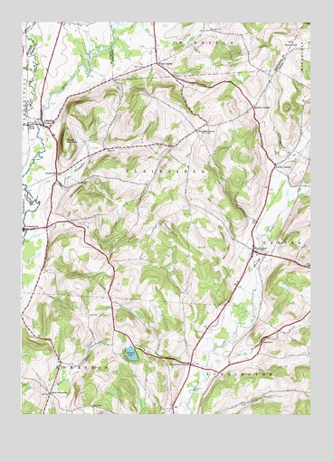
Unadilla Forks, NY USGS Topographic Map
Click on map above to begin viewing in our Map Viewer.

This topographic map contains these locations and features:
Feature Name Type Latitude Longitude GNIS ID View Map
Bass CemeteryCemeteryN42.7817°W75.2204°943140View Map
Beverly Inn CornersLocaleN42.7659°W75.1766°943820View Map
Burgess CemeteryCemeteryN42.8731°W75.1682°945208View Map
Campbell BrookStreamN42.8178°W75.2441°945695View Map
Dundee BrookStreamN42.7701°W75.1668°948785View Map
Hoxie CemeteryCemeteryN42.8215°W75.2499°953340View Map
Huntly CemeteryCemeteryN42.8300°W75.1375°2365196View Map
Huntly CornersPopulated PlaceN42.8295°W75.1402°953505View Map
LloydsvillePopulated PlaceN42.8265°W75.2343°955768View Map
Mount MarkhamSummitN42.8370°W75.2310°956537View Map
Noahs RumpSummitN42.8103°W75.1863°958634View Map
North EdmestonPopulated PlaceN42.7567°W75.2371°972863View Map
PecktownPopulated PlaceN42.7731°W75.1460°960090View Map
Plainfield CenterPopulated PlaceN42.8403°W75.1743°960661View Map
River ForksLocaleN42.8423°W75.2468°962555View Map
Round TopSummitN42.8690°W75.1329°963026View Map
School Number 8 (historical)SchoolN42.7578°W75.2386°2365198View Map
Spooner CornersLocaleN42.8481°W75.1499°966031View Map
Stonegate Country Club at Summit LakesLocaleN42.8046°W75.2275°2598957View Map
Summit LakeLakeN42.7694°W75.2023°966773View Map
Taylor Hill CemeteryCemeteryN42.7504°W75.2166°967090View Map
TGP-245 HeliportAirportN42.8733°W75.1708°975805View Map
Town of PlainfieldCivilN42.8284°W75.1947°979374View Map
Unadilla ForksPopulated PlaceN42.8417°W75.2402°968119View Map
Unadilla Forks CemeteryCemeteryN42.8467°W75.2333°2365197View Map
Unadilla Forks Volunteer Fire CompanyBuildingN42.8417°W75.2382°2735173View Map
Welch HillSummitN42.8026°W75.1613°969023View Map
West Branch Unadilla RiverStreamN42.8428°W75.2421°969141View Map
West ExeterPopulated PlaceN42.8023°W75.1496°969218View Map
West Exeter CemeteryCemeteryN42.8000°W75.1444°2558731View Map
West Exeter Fire DepartmentBuildingN42.8019°W75.1496°2718641View Map
Wood CemeteryCemeteryN42.8609°W75.1971°971593View Map
Woods CornersPopulated PlaceN42.8620°W75.1916°971702View Map

Note: Coordinates in the location and feature list above are referenced to NAD83 datum.


Copyright (C) 2008-2024 Ryan Niemi / Sunset Dynamics ... All Rights Reserved