TopoQuest Logo
Do you find TopoQuest useful?
Help keep TopoQuest running and adding new maps/features by donating!
Bitcoin:  19c7KJd3qBynnjoSw5npx9KScwjBe4ifkT
Litecoin:  LXs6TkuXGGXo1vDsWCkWVdjQX94eUKd6ui
Home View Maps Find Maps Find Places Resources & Links


Schuyler Lake, New York Topographic Map

USGS Map Title: Schuyler Lake, NY
USGS Map MRC: 42075G1
DRG (GeoTIFF) Download: o42075g1.tif


Neighboring USGS Topographic Map Quads:


  West Winfield, NY  
42075H2
 

  Millers Mills, NY  
42075H1
 

  Jordanville, NY  
42074H8
 

  Unadilla Forks, NY  
42075G2
 

  Schuyler Lake, NY  
42075G1
 

  Richfield Springs, NY  
42074G8
 

  Edmeston, NY  
42075F2
 

  Hartwick, NY  
42075F1
 

  Cooperstown, NY  
42074F8


Map MRC Location:

N43°
W76°
N43°
W75°
H8 H7 H6 H5 H4 H3 H2 H1
G8 G7 G6 G5 G4 G3 G2 G1
F8 F7 F6 F5 F4 F3 F2 F1
E8 E7 E6 E5 E4 E3 E2 E1
D8 D7 D6 D5 D4 D3 D2 D1
C8 C7 C6 C5 C4 C3 C2 C1
B8 B7 B6 B5 B4 B3 B2 B1
A8 A7 A6 A5 A4 A3 A2 A1
N42°
W76°
N42°
W75°

Schuyler Lake, NY USGS 1:24K Topographic Map Preview:
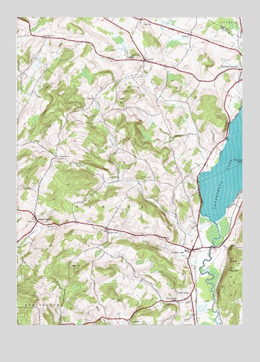
Schuyler Lake, NY USGS Topographic Map
Click on map above to begin viewing in our Map Viewer.

This topographic map contains these locations and features:
Feature Name Type Latitude Longitude GNIS ID View Map
Angel HillSummitN42.7731°W75.0913°942476View Map
Brainard CornersLocaleN42.7920°W75.1132°944603View Map
BrightonPopulated PlaceN42.8678°W75.0288°944744View Map
Canadarago LakeLakeN42.8151°W75.0062°945728View Map
Cobblestone School (historical)SchoolN42.8187°W75.1029°946977View Map
DogtownPopulated PlaceN42.8417°W75.0824°972389View Map
Exeter CemeteryCemeteryN42.7917°W75.0843°949787View Map
Exeter CornerPopulated PlaceN42.7887°W75.0746°949788View Map
Gunset HillSummitN42.8585°W75.0208°2791105View Map
Hawk HillSummitN42.8426°W75.0671°952395View Map
Herkimer CemeteryCemeteryN42.7898°W75.0260°952622View Map
Herkimer CreekStreamN42.7920°W75.0165°952624View Map
Hyder CreekStreamN42.8123°W75.0179°953563View Map
Kingdom Hall of Jehovahs WitnessesChurchN42.7818°W75.0267°2597898View Map
Lidell CornersPopulated PlaceN42.7626°W75.0285°955285View Map
Lidell CreekStreamN42.7604°W75.0157°955286View Map
Mink CreekStreamN42.8392°W75.0002°957411View Map
Nine HillSummitN42.8426°W75.0198°2791116View Map
Phinney CreekStreamN42.7562°W75.0163°960314View Map
Pleasant Valley School (historical)SchoolN42.7601°W75.0371°960737View Map
Pray HillSummitN42.8723°W75.0554°961104View Map
PunchbowlCliffN42.8273°W75.0574°961981View Map
RichfieldPopulated PlaceN42.8573°W75.0540°962468View Map
Ryder School (historical)SchoolN42.8098°W75.0690°963141View Map
School Number 5 (historical)SchoolN42.7923°W75.1143°975420View Map
School Number 6 (historical)SchoolN42.8670°W75.1090°975488View Map
Schuyler LakePopulated PlaceN42.7804°W75.0279°964636View Map
Schuyler Lake CemeteryCemeteryN42.7828°W75.0317°2358370View Map
Schuyler Lake Post OfficePost OfficeN42.7802°W75.0285°2598935View Map
Schuyler Lake Volunteer Fire DepartmentBuildingN42.7806°W75.0292°2735170View Map
Town of ExeterCivilN42.7941°W75.0833°978948View Map
Town of RichfieldCivilN42.8548°W75.0496°979417View Map
Twilight Rest CemeteryCemeteryN42.8580°W75.0598°968031View Map

Note: Coordinates in the location and feature list above are referenced to NAD83 datum.


Copyright (C) 2008-2024 Ryan Niemi / Sunset Dynamics ... All Rights Reserved