TopoQuest Logo
Do you find TopoQuest useful?
Help keep TopoQuest running and adding new maps/features by donating!
Bitcoin:  19c7KJd3qBynnjoSw5npx9KScwjBe4ifkT
Litecoin:  LXs6TkuXGGXo1vDsWCkWVdjQX94eUKd6ui
Home View Maps Find Maps Find Places Resources & Links


Tyrone, New Mexico Topographic Map

USGS Map Title: Tyrone, NM
USGS Map MRC: 32108F3
DRG (GeoTIFF) Download: o32108f3.tif


Neighboring USGS Topographic Map Quads:


  Circle Mesa, NM  
32108G4
 

  Silver City, NM  
32108G3
 

  Fort Bayard, NM  
32108G2
 

  Wind Mountain, NM  
32108F4
 

  Tyrone, NM  
32108F3
 

  Hurley West, NM  
32108F2
 

  Burro Peak, NM  
32108E4
 

  White Signal, NM  
32108E3
 

  Whitewater, NM  
32108E2


Map MRC Location:

N33°
W109°
N33°
W108°
H8 H7 H6 H5 H4 H3 H2 H1
G8 G7 G6 G5 G4 G3 G2 G1
F8 F7 F6 F5 F4 F3 F2 F1
E8 E7 E6 E5 E4 E3 E2 E1
D8 D7 D6 D5 D4 D3 D2 D1
C8 C7 C6 C5 C4 C3 C2 C1
B8 B7 B6 B5 B4 B3 B2 B1
A8 A7 A6 A5 A4 A3 A2 A1
N32°
W109°
N32°
W108°

Tyrone, NM USGS 1:24K Topographic Map Preview:
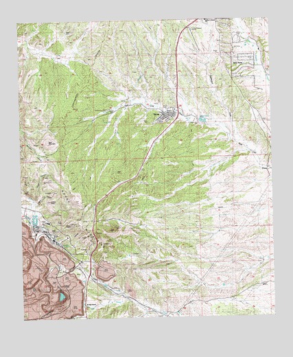
Tyrone, NM USGS Topographic Map
Click on map above to begin viewing in our Map Viewer.

This topographic map contains these locations and features:
Feature Name Type Latitude Longitude GNIS ID View Map
00446 Water WellWellN32.7481°W108.3020°919757View Map
00452 Water WellWellN32.7073°W108.2537°919741View Map
00453 Water WellWellN32.7079°W108.2770°919742View Map
00456 Water WellWellN32.7167°W108.2989°919744View Map
00458 Water WellWellN32.7090°W108.3031°919743View Map
00464 Water WellWellN32.7051°W108.2831°919205View Map
00792 Water WellWellN32.6848°W108.2520°919206View Map
00795 Water WellWellN32.6831°W108.2970°919195View Map
00797 Water WellWellN32.6779°W108.3339°919194View Map
00805 Water WellWellN32.6726°W108.3387°919215View Map
10031 Water WellWellN32.7129°W108.3353°919236View Map
10032 Water WellWellN32.7104°W108.3309°919235View Map
10033 Water WellWellN32.7070°W108.3334°919740View Map
10037 Water WellWellN32.6973°W108.3400°919199View Map
B Shaft (historical)MineN32.6395°W108.3684°900187View Map
Bald MountainSummitN32.6992°W108.3614°886016View Map
Brick Kiln GulchValleyN32.6334°W108.3237°886727View Map
Burro Springs Historic SiteLocaleN32.6606°W108.3600°933490View Map
Cedar CanyonValleyN32.6748°W108.3692°887315View Map
Colored WindmillLocaleN32.7070°W108.2548°887750View Map
Copper Gulf Shaft (historical)MineN32.6326°W108.3728°900188View Map
G 451 Water WellWellN32.7070°W108.2506°919576View Map
G 459 Water WellWellN32.7329°W108.3042°919577View Map
G 800 Water WellWellN32.6634°W108.3134°918834View Map
Gettysburg Shaft (historical)MineN32.6342°W108.3603°900189View Map
Graveyard DrawValleyN32.6990°W108.2687°906726View Map
Harrison A Schmitt SchoolSchoolN32.7495°W108.2825°900243View Map
Indian PeakSummitN32.6742°W108.3606°907218View Map
Little Burro MountainsRangeN32.7001°W108.3673°933387View Map
Niagara Gulch (historical)ValleyN32.6645°W108.3703°909082View Map
Niagara Tunnel (historical)TunnelN32.6470°W108.3745°900191View Map
Number 2 Shaft (historical)MineN32.6490°W108.3739°928999View Map
Number 3 Shaft (historical)MineN32.6456°W108.3737°929000View Map
Oak GrovePopulated PlaceN32.6309°W108.3448°898579View Map
OramanLocaleN32.7051°W108.3414°929277View Map
Racket Shaft (historical)MineN32.6351°W108.3667°900194View Map
Silver AcresPopulated PlaceN32.7301°W108.2637°900251View Map
Silver King-Mystery GroupsMineN32.6823°W108.3639°914892View Map
Turner Ridgeport Airport (historical)AirportN32.7417°W108.2867°937025View Map
TyronePopulated PlaceN32.7098°W108.3020°938834View Map
TyroneLocaleN32.6570°W108.3595°900258View Map
Tyrone Census Designated PlaceCensusN32.7099°W108.3027°2584229View Map
Tyrone MillMineN32.6584°W108.3589°914913View Map
Tyrone MineMineN32.6440°W108.3678°900254View Map
Tyrone Post Office (historical)Post OfficeN32.7098°W108.3012°937311View Map
Tyrone Volunteer Fire DepartmentBuildingN32.7130°W108.2993°2657709View Map
Virtue MineMineN32.6820°W108.3684°914934View Map

Note: Coordinates in the location and feature list above are referenced to NAD83 datum.


Copyright (C) 2008-2024 Ryan Niemi / Sunset Dynamics ... All Rights Reserved