TopoQuest Logo
Do you find TopoQuest useful?
Help keep TopoQuest running and adding new maps/features by donating!
Bitcoin:  19c7KJd3qBynnjoSw5npx9KScwjBe4ifkT
Litecoin:  LXs6TkuXGGXo1vDsWCkWVdjQX94eUKd6ui
Home View Maps Find Maps Find Places Resources & Links


Twin Buttes, New Mexico Topographic Map

USGS Map Title: Twin Buttes, NM
USGS Map MRC: 35108D7
DRG (GeoTIFF) Download: o35108d7.tif


Neighboring USGS Topographic Map Quads:


  Samson Lake, NM  
35108E8
 

  Gallup West, NM  
35108E7
 

  Gallup East, NM  
35108E6
 

  Manuelito, NM  
35108D8
 

  Twin Buttes, NM  
35108D7
 

  Bread Springs, NM  
35108D6
 

  Jones Ranch School, NM  
35108C8
 

  Vanderwagen, NM  
35108C7
 

  Pinehaven, NM  
35108C6


Map MRC Location:

N36°
W109°
N36°
W108°
H8 H7 H6 H5 H4 H3 H2 H1
G8 G7 G6 G5 G4 G3 G2 G1
F8 F7 F6 F5 F4 F3 F2 F1
E8 E7 E6 E5 E4 E3 E2 E1
D8 D7 D6 D5 D4 D3 D2 D1
C8 C7 C6 C5 C4 C3 C2 C1
B8 B7 B6 B5 B4 B3 B2 B1
A8 A7 A6 A5 A4 A3 A2 A1
N35°
W109°
N35°
W108°

Twin Buttes, NM USGS 1:24K Topographic Map Preview:
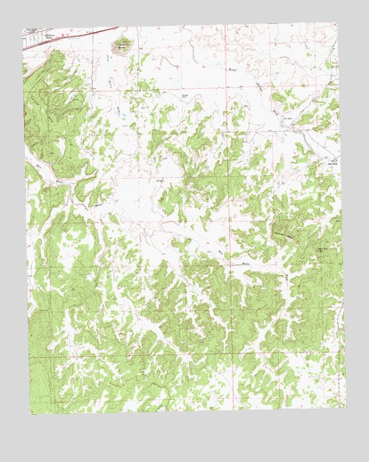
Twin Buttes, NM USGS Topographic Map
Click on map above to begin viewing in our Map Viewer.

This topographic map contains these locations and features:
Feature Name Type Latitude Longitude GNIS ID View Map
Black WellWellN35.4086°W108.8673°886463View Map
Gallup Titanium DepositMineN35.4831°W108.8698°917368View Map
Grenko MineMineN35.4870°W108.7684°917384View Map
Leyba MineMineN35.4720°W108.8576°917399View Map
Manning MineMineN35.4834°W108.8337°917517View Map
Mutual Col Water WellWellN35.4986°W108.7890°921769View Map
Olson PitMineN35.4861°W108.8390°917572View Map
Red RockPopulated PlaceN35.4542°W108.7559°902339View Map
Red Rock ChapterCivilN35.4260°W108.8066°2419072View Map
Red Rock HillSummitN35.4261°W108.7606°899870View Map
Refuge RockSummitN35.4772°W108.8129°899871View Map
Remnant MesaSummitN35.4311°W108.7740°899873View Map
Rico RanchLocaleN35.4689°W108.7734°893889View Map
Thatcher MineMineN35.4831°W108.8331°917504View Map
Torrivio MesaSummitN35.4761°W108.8729°895772View Map
Tree WellWellN35.4770°W108.8568°895812View Map
Twin Buttes PitMineN35.4997°W108.8387°917553View Map
Twin Knoll ButtesSummitN35.4942°W108.8345°899968View Map
U.S. Mining-Olsen MineMineN35.4864°W108.7868°917380View Map
Williams AcresLocaleN35.4975°W108.8665°896625View Map

Note: Coordinates in the location and feature list above are referenced to NAD83 datum.


Copyright (C) 2008-2024 Ryan Niemi / Sunset Dynamics ... All Rights Reserved