TopoQuest Logo
Do you find TopoQuest useful?
Help keep TopoQuest running and adding new maps/features by donating!
Bitcoin:  19c7KJd3qBynnjoSw5npx9KScwjBe4ifkT
Litecoin:  LXs6TkuXGGXo1vDsWCkWVdjQX94eUKd6ui
Home View Maps Find Maps Find Places Resources & Links


Manuelito, New Mexico Topographic Map

USGS Map Title: Manuelito, NM
USGS Map MRC: 35108D8
DRG (GeoTIFF) Download: o35108d8.tif


Neighboring USGS Topographic Map Quads:


  Hunters Point, AZ  
35109E1
 

  Samson Lake, NM  
35108E8
 

  Gallup West, NM  
35108E7
 

  Surrender Canyon, NM  
35109D1
 

  Manuelito, NM  
35108D8
 

  Twin Buttes, NM  
35108D7
 

  Lupton, AZ  
35109C1
 

  Jones Ranch School, NM  
35108C8
 

  Vanderwagen, NM  
35108C7


Map MRC Location:

N36°
W109°
N36°
W108°
H8 H7 H6 H5 H4 H3 H2 H1
G8 G7 G6 G5 G4 G3 G2 G1
F8 F7 F6 F5 F4 F3 F2 F1
E8 E7 E6 E5 E4 E3 E2 E1
D8 D7 D6 D5 D4 D3 D2 D1
C8 C7 C6 C5 C4 C3 C2 C1
B8 B7 B6 B5 B4 B3 B2 B1
A8 A7 A6 A5 A4 A3 A2 A1
N35°
W109°
N35°
W108°

Manuelito, NM USGS 1:24K Topographic Map Preview:
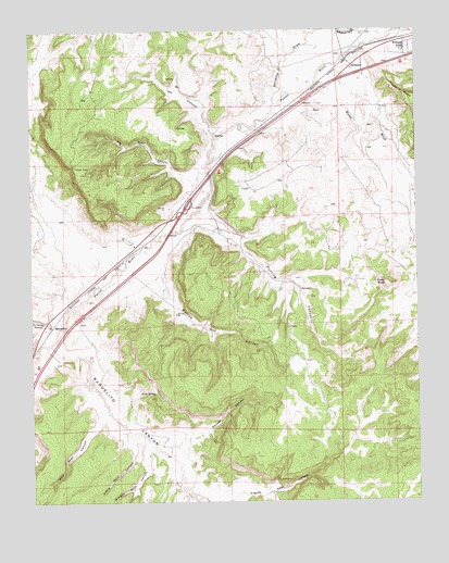
Manuelito, NM USGS Topographic Map
Click on map above to begin viewing in our Map Viewer.

This topographic map contains these locations and features:
Feature Name Type Latitude Longitude GNIS ID View Map
Atsee Nitsaa Historic SiteLocaleN35.4220°W108.9940°933541View Map
Big House CanyonValleyN35.3770°W108.9512°886308View Map
Big House Historic SiteLocaleN35.4220°W108.9940°933461View Map
Big Rock CanyonValleyN35.4611°W108.9445°886323View Map
Burned Out CanyonValleyN35.4347°W108.9584°886934View Map
DefiancePopulated PlaceN35.4906°W108.8965°902813View Map
Defiance DrawValleyN35.4803°W108.9215°902814View Map
Defiance Post Office (historical)Post OfficeN35.4906°W108.8965°937528View Map
Eagles Nest CanyonValleyN35.3750°W108.9445°888625View Map
Hunting CanyonValleyN35.4489°W108.9459°890269View Map
Kin Hocho'i Historic SiteLocaleN35.4220°W108.9940°933776View Map
Leo CanyonValleyN35.4711°W108.9406°891045View Map
Little Rock CanyonValleyN35.3906°W108.9684°891173View Map
ManuelitoPopulated PlaceN35.4220°W108.9940°902831View Map
Manuelito Area Historical MarkerParkN35.4220°W108.9940°931689View Map
Manuelito CanyonValleyN35.4159°W108.9934°908394View Map
Manuelito Post Office (historical)Post OfficeN35.4220°W108.9937°937530View Map
Naat'a'anil BikinLocaleN35.4220°W108.9940°935703View Map
Purty RockSummitN35.4328°W108.8856°893563View Map
Salt Water WashStreamN35.4761°W108.9240°894365View Map
Sand SpringSpringN35.4040°W108.9660°894519View Map
Squash CanyonValleyN35.3920°W108.9495°895284View Map
Stepping Stone House Historic SiteLocaleN35.4309°W108.9940°933763View Map
Surrender CanyonValleyN35.4222°W108.9962°895448View Map
Vasquez de Coronados Route Historical MarkerParkN35.4220°W108.9940°931670View Map
Wild Goat CanyonValleyN35.3975°W108.9787°896588View Map
Williams AcresLocaleN35.4953°W108.8784°915915View Map
Window Rock CanyonValleyN35.3892°W108.9643°896706View Map
Wolye A'dinLocaleN35.4158°W108.9928°935692View Map

Note: Coordinates in the location and feature list above are referenced to NAD83 datum.


Copyright (C) 2008-2024 Ryan Niemi / Sunset Dynamics ... All Rights Reserved