TopoQuest Logo
Do you find TopoQuest useful?
Help keep TopoQuest running and adding new maps/features by donating!
Bitcoin:  19c7KJd3qBynnjoSw5npx9KScwjBe4ifkT
Litecoin:  LXs6TkuXGGXo1vDsWCkWVdjQX94eUKd6ui
Home View Maps Find Maps Find Places Resources & Links


Tintic Junction, Utah Topographic Map

USGS Map Title: Tintic Junction, UT
USGS Map MRC: 39112H2
DRG (GeoTIFF) Download: o39112h2.tif


Neighboring USGS Topographic Map Quads:


  Lofgreen, UT  
40112A3
 

  Boulter Peak, UT  
40112A2
 

  Allens Ranch, UT  
40112A1
 

  Sabie Mountain, UT  
39112H3
 

  Tintic Junction, UT  
39112H2
 

  Eureka, UT  
39112H1
 

  Maple Peak, UT  
39112G3
 

  McIntyre, UT  
39112G2
 

  Tintic Mountain, UT  
39112G1


Map MRC Location:

N40°
W113°
N40°
W112°
H8 H7 H6 H5 H4 H3 H2 H1
G8 G7 G6 G5 G4 G3 G2 G1
F8 F7 F6 F5 F4 F3 F2 F1
E8 E7 E6 E5 E4 E3 E2 E1
D8 D7 D6 D5 D4 D3 D2 D1
C8 C7 C6 C5 C4 C3 C2 C1
B8 B7 B6 B5 B4 B3 B2 B1
A8 A7 A6 A5 A4 A3 A2 A1
N39°
W113°
N39°
W112°

Tintic Junction, UT USGS 1:24K Topographic Map Preview:
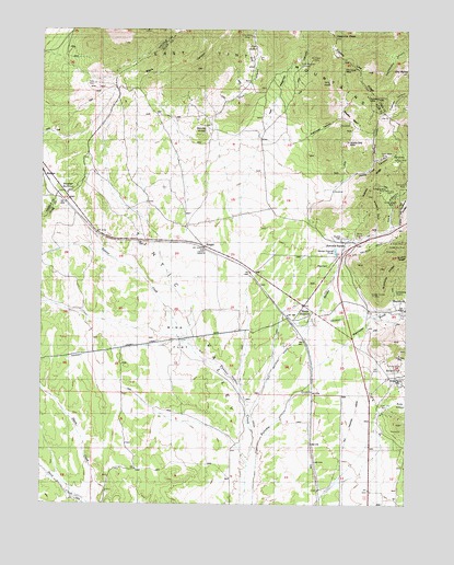
Tintic Junction, UT USGS Topographic Map
Click on map above to begin viewing in our Map Viewer.

This topographic map contains these locations and features:
Feature Name Type Latitude Longitude GNIS ID View Map
Black CanyonValleyN39.9833°W112.2161°1425656View Map
Black Warrior MineMineN39.9580°W112.1308°1425730View Map
Bluebird SpurRidgeN39.9524°W112.1369°1425837View Map
BoulterLocaleN39.9613°W112.2497°1425900View Map
Boulter SummitSummitN39.9586°W112.2422°1425902View Map
Bradley BasinBasinN39.9774°W112.1463°1425938View Map
Bradley MineMineN39.9824°W112.1394°1425939View Map
Cole CanyonValleyN39.9486°W112.1316°1437959View Map
County Line RidgeRidgeN39.9958°W112.1508°1426979View Map
Dagmar MineMineN39.9586°W112.1372°1427182View Map
Dan Hough MineMineN39.9888°W112.1477°1427197View Map
Dragon CanyonValleyN39.9080°W112.1286°1427470View Map
Eureka CemeteryCemeteryN39.9449°W112.1472°1437239View Map
Evans MineMineN39.9441°W112.1311°1427859View Map
Fields ProspectMineN39.9849°W112.1316°1427919View Map
Fitch CemeteryCemeteryN39.9375°W112.1528°1427971View Map
Four Aces MineMineN39.9124°W112.1316°1428052View Map
Garity QuarryMineN39.9455°W112.1422°1428145View Map
General Logan MineMineN39.9463°W112.1280°1428166View Map
Golden Ray MineMineN39.9427°W112.1297°1428239View Map
Golden Sunset MineMineN39.9302°W112.1372°1428244View Map
Hannifin PeakSummitN39.9983°W112.1505°1428511View Map
Hannifin RanchLocaleN39.9433°W112.1472°1428512View Map
Hatfield CanyonValleyN39.9658°W112.1374°1428587View Map
HerkimerMineN39.9372°W112.1252°1428674View Map
Iron CanyonValleyN39.9761°W112.1933°1437986View Map
Jenny Lind CanyonValleyN39.9588°W112.1491°1429144View Map
Keystone RidgeRidgeN39.9552°W112.1263°1429338View Map
Kingsley MineMineN39.9161°W112.1308°1429363View Map
KnightPopulated PlaceN39.9433°W112.1961°1437605View Map
Limestone QuarryMineN39.9305°W112.1286°1429635View Map
MammothPopulated PlaceN39.9263°W112.1263°1451119View Map
Mammoth GulchValleyN39.9111°W112.1577°1437995View Map
Mammoth JunctionPopulated PlaceN39.9369°W112.1486°1437632View Map
Munding ProspectMineN39.9972°W112.1827°1430604View Map
North Beck MineMineN39.9669°W112.1341°1430747View Map
Old BaldySummitN39.9888°W112.1283°1430965View Map
Picnic MineMineN39.9116°W112.1299°1431220View Map
Porphyry FlatFlatN39.9663°W112.1280°1431421View Map
Quartzite RidgeRidgeN39.9366°W112.1333°1431520View Map
Retribution MineMineN39.9599°W112.1266°1431759View Map
Robinson CanyonValleyN39.9722°W112.1619°1454320View Map
Round KnollSummitN39.9727°W112.1966°1432020View Map
Ruby HollowValleyN39.9008°W112.1319°1432044View Map
Sacramento MineMineN39.9549°W112.1299°1432076View Map
Silver Bow MineMineN39.9141°W112.1280°1432451View Map
Silver CityPopulated PlaceN39.9099°W112.1299°1437686View Map
Silver City CemeteryCemeteryN39.9022°W112.1342°1432453View Map
Snell RanchLocaleN39.9544°W112.1599°1432591View Map
Swansea MineMineN39.9141°W112.1330°1433107View Map
Teutonic RidgeRidgeN39.9608°W112.1377°1433248View Map
Tintic JunctionPopulated PlaceN39.9272°W112.1608°1438031View Map
Tintic Prince MineMineN39.9983°W112.1794°1433550View Map
Tintic StationLocaleN39.9241°W112.1666°1433551View Map
Van Wagoner CanyonValleyN39.9749°W112.1730°1433874View Map
Van Wagoner MineMineN39.9911°W112.1624°1433875View Map
Victoria Northwest MineMineN39.9708°W112.1463°1433891View Map
Waveland MineMineN39.9924°W112.1583°1434017View Map
West Swansea MineMineN39.9166°W112.1341°1434122View Map
Wing FlatFlatN39.9188°W112.2036°1434401View Map
Yankee Girl MineMineN39.9083°W112.1277°1434492View Map

Note: Coordinates in the location and feature list above are referenced to NAD83 datum.


Copyright (C) 2008-2024 Ryan Niemi / Sunset Dynamics ... All Rights Reserved