TopoQuest Logo
Do you find TopoQuest useful?
Help keep TopoQuest running and adding new maps/features by donating!
Bitcoin:  19c7KJd3qBynnjoSw5npx9KScwjBe4ifkT
Litecoin:  LXs6TkuXGGXo1vDsWCkWVdjQX94eUKd6ui
Home View Maps Find Maps Find Places Resources & Links


Blue Lake, California Topographic Map

USGS Map Title: Blue Lake, CA
USGS Map MRC: 40123H8
DRG (GeoTIFF) Download: o40123h8.tif


Neighboring USGS Topographic Map Quads:


  Crannell, CA  
41124A1
 

  Panther Creek, CA  
41123A8
 

  Hupa Mountain, CA  
41123A7
 

  Arcata North, CA  
40124H1
 

  Blue Lake, CA  
40123H8
 

  Lord-Ellis Summit, CA  
40123H7
 

  Arcata South, CA  
40124G1
 

  Korbel, CA  
40123G8
 

  Maple Creek, CA  
40123G7


Map MRC Location:

N41°
W124°
N41°
W123°
H8 H7 H6 H5 H4 H3 H2 H1
G8 G7 G6 G5 G4 G3 G2 G1
F8 F7 F6 F5 F4 F3 F2 F1
E8 E7 E6 E5 E4 E3 E2 E1
D8 D7 D6 D5 D4 D3 D2 D1
C8 C7 C6 C5 C4 C3 C2 C1
B8 B7 B6 B5 B4 B3 B2 B1
A8 A7 A6 A5 A4 A3 A2 A1
N40°
W124°
N40°
W123°

Blue Lake, CA USGS 1:24K Topographic Map Preview:
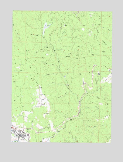
Blue Lake, CA USGS Topographic Map
Click on map above to begin viewing in our Map Viewer.

This topographic map contains these locations and features:
Feature Name Type Latitude Longitude GNIS ID View Map
Bald Mountain CreekStreamN40.8985°W123.9167°256467View Map
Blue LakePopulated PlaceN40.8829°W123.9839°1658083View Map
Blue Lake Branch Humboldt County LibraryBuildingN40.8826°W123.9917°1681866View Map
Blue Lake CemeteryCemeteryN40.8798°W123.9825°2755369View Map
Blue Lake City HallBuildingN40.8826°W123.9917°1681867View Map
Blue Lake Elementary SchoolSchoolN40.8852°W123.9914°1681868View Map
Blue Lake Fire Protection DistrictBuildingN40.8830°W123.9911°1681869View Map
Blue Lake Industrial ParkLocaleN40.8790°W123.9934°1681870View Map
Blue Lake MuseumBuildingN40.8810°W123.9901°1681871View Map
Blue Lake Police DepartmentBuildingN40.8826°W123.9920°2751073View Map
Blue Lake Post OfficePost OfficeN40.8816°W123.9890°1681872View Map
Blue Lake RancheriaCivilN40.8847°W123.9997°2419316View Map
Camp BauerLocaleN40.8793°W123.9506°220440View Map
Camp Eight (historical)LocaleN40.9221°W123.9417°1682562View Map
Canyon CreekStreamN40.9618°W123.9481°220557View Map
City of Blue LakeCivilN40.8814°W123.9929°2409868View Map
Crawford RanchLocaleN40.8951°W123.9831°1682566View Map
Dell'Arte International School of Physical TheatreSchoolN40.8809°W123.9889°2370674View Map
Denman CreekStreamN40.9296°W123.9345°222261View Map
Dolf CreekStreamN40.9657°W123.9584°222473View Map
East Fork North Fork Mad RiverStreamN40.9649°W123.9498°253707View Map
Fawn PrairieAreaN40.9585°W123.8978°223416View Map
Gosinta CreekStreamN40.9232°W123.9264°224352View Map
Gymkhana FieldParkN40.8807°W123.9928°1681906View Map
Jackson CreekStreamN40.9415°W123.9412°226081View Map
Jiggs CreekStreamN40.8876°W123.9348°226236View Map
Korbel-Blue Lake Community ChurchChurchN40.8837°W123.9898°1681910View Map
Krueger CreekStreamN40.9457°W123.9437°226689View Map
Liscom HillSummitN40.9196°W123.9617°1658965View Map
Long PrairieAreaN40.9382°W123.8770°262872View Map
Long Prairie CreekStreamN40.9218°W123.9067°262873View Map
Miller PrairieAreaN40.9393°W123.8920°228743View Map
Mule CreekStreamN40.9362°W123.9359°229302View Map
Northern Redwood Camp (historical)LocaleN40.9440°W123.9253°1682575View Map
Perigot ParkParkN40.8821°W123.9928°1681921View Map
Pine CreekStreamN40.9137°W123.9159°230678View Map
Pollock CreekStreamN40.9062°W123.9145°253778View Map
Poverty PointSummitN40.9021°W123.9587°231008View Map
Powers CreekStreamN40.8807°W123.9892°231020View Map
Prasch HallBuildingN40.8818°W123.9928°1681922View Map
Presbyterian Church of Blue LakeChurchN40.8815°W123.9881°1681923View Map
Preston Ranch (historical)LocaleN40.9415°W123.8756°1665267View Map
Quarry CreekStreamN40.8754°W123.9992°231121View Map
Railroad CreekStreamN40.9540°W123.9434°231175View Map
Round PrairieAreaN40.9612°W123.8881°231969View Map
Saint Josephs Catholic ChurchChurchN40.8835°W123.9912°1681929View Map
The BasinSwampN40.9839°W123.9596°236144View Map
Tip Top RidgeRidgeN40.9332°W123.9678°233385View Map
Tyson CreekStreamN40.9762°W123.9626°236748View Map
Wiregrass RidgeRidgeN40.9682°W123.8907°238069View Map

Note: Coordinates in the location and feature list above are referenced to NAD83 datum.


Copyright (C) 2008-2024 Ryan Niemi / Sunset Dynamics ... All Rights Reserved