TopoQuest Logo
Do you find TopoQuest useful?
Help keep TopoQuest running and adding new maps/features by donating!
Bitcoin:  19c7KJd3qBynnjoSw5npx9KScwjBe4ifkT
Litecoin:  LXs6TkuXGGXo1vDsWCkWVdjQX94eUKd6ui
Home View Maps Find Maps Find Places Resources & Links


Temple, Louisiana Topographic Map

USGS Map Title: Temple, LA
USGS Map MRC: 31092C8
DRG (GeoTIFF) Download: o31092c8.tif


Neighboring USGS Topographic Map Quads:


  Bayou Livrogne, LA  
31093D1
 

  Gorum, LA  
31092D8
 

  Lena, LA  
31092D7
 

  Simpson North, LA  
31093C1
 

  Temple, LA  
31092C8
 

  Jericho, LA  
31092C7
 

  Simpson South, LA  
31093B1
 

  Lacamp, LA  
31092B8
 

  Sieper, LA  
31092B7


Map MRC Location:

N32°
W93°
N32°
W92°
H8 H7 H6 H5 H4 H3 H2 H1
G8 G7 G6 G5 G4 G3 G2 G1
F8 F7 F6 F5 F4 F3 F2 F1
E8 E7 E6 E5 E4 E3 E2 E1
D8 D7 D6 D5 D4 D3 D2 D1
C8 C7 C6 C5 C4 C3 C2 C1
B8 B7 B6 B5 B4 B3 B2 B1
A8 A7 A6 A5 A4 A3 A2 A1
N31°
W93°
N31°
W92°

Temple, LA USGS 1:24K Topographic Map Preview:
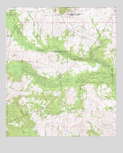
Temple, LA USGS Topographic Map
Click on map above to begin viewing in our Map Viewer.

This topographic map contains these locations and features:
Feature Name Type Latitude Longitude GNIS ID View Map
Bayou CelestineStreamN31.3021°W92.8871°532496View Map
Bayou Pine CoupeeStreamN31.3252°W92.9018°553508View Map
Bee BranchStreamN31.2585°W92.9860°547048View Map
Blackwell CemeteryCemeteryN31.2991°W92.9140°547100View Map
BurnstownPopulated PlaceN31.2824°W92.9349°547152View Map
ComradePopulated PlaceN31.3218°W92.9643°549986View Map
Comrade CemeteryCemeteryN31.3291°W92.9913°547241View Map
Comrade ChurchChurchN31.3091°W92.9382°547242View Map
Cypress BranchStreamN31.3438°W92.9821°554162View Map
Devils CreekStreamN31.3049°W92.8785°554231View Map
Elliot School (historical)SchoolN31.3552°W92.9071°551703View Map
Flatwoods Volunteer Fire Department Station 2BuildingN31.3479°W92.9178°2672993View Map
Gum BranchStreamN31.3355°W92.9546°547427View Map
HoodPopulated PlaceN31.2885°W92.8932°550016View Map
Jacksonville (historical)Populated PlaceN31.3241°W92.9913°550021View Map
Marl BranchStreamN31.3382°W92.9588°547648View Map
Menace CreekStreamN31.2585°W92.9860°547681View Map
Middle CreekStreamN31.3021°W92.8793°547688View Map
MoraPopulated PlaceN31.3732°W92.9479°547734View Map
Mora Post OfficePost OfficeN31.3693°W92.9424°1630950View Map
Mora SchoolSchoolN31.3746°W92.9652°547736View Map
Pentecost ChurchChurchN31.3455°W92.9135°547827View Map
Pine CoupeePopulated PlaceN31.3743°W92.8990°547840View Map
Pine Grove ChurchChurchN31.3668°W92.9938°547841View Map
Red Top Church (historical)ChurchN31.3460°W92.9146°551766View Map
Schorn Brook CemeteryCemeteryN31.3366°W92.8907°547980View Map
Shinglemill BranchStreamN31.2518°W92.9738°547993View Map
Spanish BranchStreamN31.3493°W92.8952°548011View Map
Spanish Branch ChurchChurchN31.3607°W92.9349°548012View Map
Spring BranchStreamN31.3438°W92.9824°548020View Map
TemplePopulated PlaceN31.2782°W92.9554°548069View Map
Temple SpurLocaleN31.3052°W92.9402°548070View Map
Ward SixCivilN31.2691°W92.9874°545252View Map
Waterhole BranchStreamN31.2771°W92.9210°548125View Map
Zimmerman CampLocaleN31.3418°W92.8949°556492View Map

Note: Coordinates in the location and feature list above are referenced to NAD83 datum.


Copyright (C) 2008-2024 Ryan Niemi / Sunset Dynamics ... All Rights Reserved