TopoQuest Logo
Do you find TopoQuest useful?
Help keep TopoQuest running and adding new maps/features by donating!
Bitcoin:  19c7KJd3qBynnjoSw5npx9KScwjBe4ifkT
Litecoin:  LXs6TkuXGGXo1vDsWCkWVdjQX94eUKd6ui
Home View Maps Find Maps Find Places Resources & Links


Sieper, Louisiana Topographic Map

USGS Map Title: Sieper, LA
USGS Map MRC: 31092B7
DRG (GeoTIFF) Download: o31092b7.tif


Neighboring USGS Topographic Map Quads:


  Temple, LA  
31092C8
 

  Jericho, LA  
31092C7
 

  Gardner, LA  
31092C6
 

  Lacamp, LA  
31092B8
 

  Sieper, LA  
31092B7
 

  Elmer, LA  
31092B6
 

  Fullerton Lake, LA  
31092A8
 

  Afeman, LA  
31092A7
 

  Melder, LA  
31092A6


Map MRC Location:

N32°
W93°
N32°
W92°
H8 H7 H6 H5 H4 H3 H2 H1
G8 G7 G6 G5 G4 G3 G2 G1
F8 F7 F6 F5 F4 F3 F2 F1
E8 E7 E6 E5 E4 E3 E2 E1
D8 D7 D6 D5 D4 D3 D2 D1
C8 C7 C6 C5 C4 C3 C2 C1
B8 B7 B6 B5 B4 B3 B2 B1
A8 A7 A6 A5 A4 A3 A2 A1
N31°
W93°
N31°
W92°

Sieper, LA USGS 1:24K Topographic Map Preview:
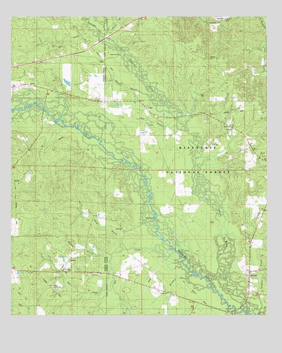
Sieper, LA USGS Topographic Map
Click on map above to begin viewing in our Map Viewer.

This topographic map contains these locations and features:
Feature Name Type Latitude Longitude GNIS ID View Map
Big CreekStreamN31.1471°W92.7915°547078View Map
Big Hammock ChurchChurchN31.1438°W92.8460°547084View Map
Big Hammock School (historical)SchoolN31.1460°W92.8127°551672View Map
Burns CemeteryCemeteryN31.2168°W92.7804°547151View Map
Clifton CrossingPopulated PlaceN31.2343°W92.8221°547232View Map
Comrade CreekStreamN31.2427°W92.8288°554065View Map
Cypress BayouStreamN31.1427°W92.7824°547276View Map
Dan BranchStreamN31.2416°W92.8290°547286View Map
Dixie Baptist ChurchChurchN31.2030°W92.7674°554246View Map
Dixie School (historical)SchoolN31.2024°W92.7682°551700View Map
Gum BranchStreamN31.2021°W92.7885°547425View Map
Hardshell CemeteryCemeteryN31.2324°W92.7779°547437View Map
HemphillPopulated PlaceN31.2493°W92.7746°543287View Map
HinestonPopulated PlaceN31.1435°W92.7588°547466View Map
Hineston BranchStreamN31.1269°W92.7538°547467View Map
Hineston Post OfficePost OfficeN31.1451°W92.7592°1631734View Map
Holt CemeteryCemeteryN31.1966°W92.7768°547473View Map
Houge BranchStreamN31.1530°W92.8204°547482View Map
Howell BranchStreamN31.2438°W92.8288°547485View Map
LeanderPopulated PlaceN31.1485°W92.8465°555010View Map
Leander ChurchChurchN31.1424°W92.8352°547569View Map
Leander Post OfficePost OfficeN31.1435°W92.8496°1631380View Map
Little Dry CreekStreamN31.1282°W92.8671°547603View Map
Majors BranchStreamN31.2155°W92.8049°547644View Map
Merchant BranchStreamN31.1366°W92.7790°547682View Map
Mill CreekStreamN31.1446°W92.8257°555320View Map
Mineral BranchStreamN31.1505°W92.8263°547725View Map
Muse (historical)Populated PlaceN31.2218°W92.7974°551743View Map
Nichols Landing StripAirportN31.1374°W92.8552°555497View Map
Pisgah Church CemeteryCemeteryN31.2393°W92.8163°547852View Map
Price CrossingPopulated PlaceN31.1657°W92.8043°547871View Map
Roland AirportAirportN31.1707°W92.7550°2676774View Map
Saint Jude ChurchChurchN31.2046°W92.8088°547930View Map
SieperPopulated PlaceN31.2110°W92.8082°556042View Map
Sieper CreekStreamN31.2432°W92.8307°556043View Map
Sieper Post OfficePost OfficeN31.2110°W92.8079°1631772View Map
Smith CemeteryCemeteryN31.1613°W92.8204°548003View Map
StillePopulated PlaceN31.2316°W92.8299°548039View Map
Twin Oak ChurchChurchN31.1341°W92.7990°548101View Map
WaldingPopulated PlaceN31.2041°W92.7679°548121View Map

Note: Coordinates in the location and feature list above are referenced to NAD83 datum.


Copyright (C) 2008-2024 Ryan Niemi / Sunset Dynamics ... All Rights Reserved