TopoQuest Logo
Do you find TopoQuest useful?
Help keep TopoQuest running and adding new maps/features by donating!
Bitcoin:  19c7KJd3qBynnjoSw5npx9KScwjBe4ifkT
Litecoin:  LXs6TkuXGGXo1vDsWCkWVdjQX94eUKd6ui
Home View Maps Find Maps Find Places Resources & Links


Sylvan Beach, New York Topographic Map

USGS Map Title: Sylvan Beach, NY
USGS Map MRC: 43075B6
DRG (GeoTIFF) Download: o43075b6.tif


Neighboring USGS Topographic Map Quads:


  Camden West, NY  
43075C7
 

  Camden East, NY  
43075C6
 

  Lee Center, NY  
43075C5
 

  Jewell, NY  
43075B7
 

  Sylvan Beach, NY  
43075B6
 

  Verona, NY  
43075B5
 

  Canastota, NY  
43075A7
 

  Oneida, NY  
43075A6
 

  Vernon, NY  
43075A5


Map MRC Location:

N44°
W76°
N44°
W75°
H8 H7 H6 H5 H4 H3 H2 H1
G8 G7 G6 G5 G4 G3 G2 G1
F8 F7 F6 F5 F4 F3 F2 F1
E8 E7 E6 E5 E4 E3 E2 E1
D8 D7 D6 D5 D4 D3 D2 D1
C8 C7 C6 C5 C4 C3 C2 C1
B8 B7 B6 B5 B4 B3 B2 B1
A8 A7 A6 A5 A4 A3 A2 A1
N43°
W76°
N43°
W75°

Sylvan Beach, NY USGS 1:24K Topographic Map Preview:
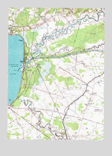
Sylvan Beach, NY USGS Topographic Map
Click on map above to begin viewing in our Map Viewer.

This topographic map contains these locations and features:
Feature Name Type Latitude Longitude GNIS ID View Map
Back Country FarmLocaleN43.1539°W75.6700°2515599View Map
Black CreekStreamN43.1640°W75.7360°944101View Map
Braband FarmLocaleN43.1792°W75.6286°2515595View Map
Brandy BrookStreamN43.1337°W75.6871°944635View Map
Brodock CemeteryCemeteryN43.2480°W75.6357°944588View Map
Bushnell PondReservoirN43.2320°W75.7441°945322View Map
Cook CemeteryCemeteryN43.2280°W75.6678°947342View Map
Doxtater CemeteryCemeteryN43.1970°W75.6519°948623View Map
Drum CreekStreamN43.2065°W75.6613°948655View Map
DumbartonPopulated PlaceN43.1623°W75.6616°948776View Map
East Oneida Lake Sewer District Wastewater Treatment FacilityLocaleN43.2141°W75.7163°2617721View Map
Edgewater BeachPopulated PlaceN43.2187°W75.7302°949376View Map
Fellowship Baptist ChurchChurchN43.1928°W75.7215°2615939View Map
Fish CreekStreamN43.1928°W75.7319°973610View Map
Fish Creek LandingPopulated PlaceN43.2209°W75.6999°950136View Map
Fish Creek StationPopulated PlaceN43.1962°W75.7130°950138View Map
Foster Ponds Golf CourseLocaleN43.1313°W75.6621°2615396View Map
Grove CemeteryCemeteryN43.1623°W75.6426°951861View Map
Hansen HeliportAirportN43.1326°W75.6549°977992View Map
Herder BridgeBridgeN43.2426°W75.6324°952618View Map
HigginsvillePopulated PlaceN43.1770°W75.6468°952720View Map
Higginsville Road BridgeBridgeN43.2058°W75.6701°2614916View Map
Holmes MarinaHarborN43.1971°W75.7218°2615030View Map
Irish RidgeRidgeN43.1576°W75.6457°953768View Map
Irish Ridge ChurchChurchN43.1592°W75.6449°953769View Map
Kamp Airport (historical)AirportN43.1345°W75.6485°977991View Map
Kanon Valley Country ClubLocaleN43.1394°W75.7151°2598907View Map
Lock 22DamN43.2095°W75.6452°974703View Map
Mill StreamStreamN43.2240°W75.7007°957283View Map
Murray BrookStreamN43.2228°W75.7452°958192View Map
Murray CemeteryCemeteryN43.2441°W75.7429°958193View Map
North BayPopulated PlaceN43.2301°W75.7482°958677View Map
North Bay Post OfficePost OfficeN43.2296°W75.7495°2618041View Map
North Bay Volunteer Fire DepartmentBuildingN43.2303°W75.7471°2734843View Map
Old Oneida Lake CanalCanalN43.1376°W75.7163°970423View Map
Oneida CreekStreamN43.1645°W75.7380°959368View Map
Oneida Lake StripAirportN43.1701°W75.7083°2787184View Map
Oneida ValleyPopulated PlaceN43.1545°W75.7213°959375View Map
Paradise HillPopulated PlaceN43.1684°W75.6402°972914View Map
Saint John's Catholic ChurchChurchN43.2302°W75.7471°2616935View Map
Skinner's HarborHarborN43.1986°W75.7250°2615045View Map
Snug HarbourHarborN43.1936°W75.7250°2615046View Map
South BayBayN43.1651°W75.7491°965667View Map
South BayPopulated PlaceN43.1567°W75.7482°965675View Map
South Bay HarborBayN43.1581°W75.7477°973475View Map
Starks LandingPopulated PlaceN43.1715°W75.6482°973113View Map
State BridgePopulated PlaceN43.1459°W75.6766°966265View Map
Stephens CreekStreamN43.1590°W75.7457°966349View Map
Stone SchoolSchoolN43.2440°W75.6871°966518View Map
Sylvan - Verona Beach Elementary SchoolSchoolN43.1879°W75.7251°2668915View Map
Sylvan BeachPopulated PlaceN43.1965°W75.7305°966955View Map
Sylvan Beach Fire DepartmentBuildingN43.1994°W75.7286°2718635View Map
Sylvan Beach Post OfficePost OfficeN43.2026°W75.7280°2618149View Map
Sylvan Springs ReservoirReservoirN43.2406°W75.7074°966960View Map
The Landing CampgroundLocaleN43.2213°W75.7020°2615243View Map
Verona BeachPopulated PlaceN43.1909°W75.7291°968504View Map
Verona Beach LightLocaleN43.1892°W75.7312°2081734View Map
Verona Beach State ParkParkN43.1778°W75.7246°968505View Map
ViennaPopulated PlaceN43.2395°W75.7024°968539View Map
Vienna Fire DepartmentBuildingN43.2397°W75.6973°2718650View Map
Vienna United Methodist ChurchChurchN43.2311°W75.7267°2617166View Map
Village of Sylvan BeachCivilN43.2060°W75.7234°2391162View Map
West CemeteryCemeteryN43.1437°W75.6537°969170View Map
Wood CreekStreamN43.2034°W75.6930°971601View Map

Note: Coordinates in the location and feature list above are referenced to NAD83 datum.


Copyright (C) 2008-2024 Ryan Niemi / Sunset Dynamics ... All Rights Reserved