TopoQuest Logo
Do you find TopoQuest useful?
Help keep TopoQuest running and adding new maps/features by donating!
Bitcoin:  19c7KJd3qBynnjoSw5npx9KScwjBe4ifkT
Litecoin:  LXs6TkuXGGXo1vDsWCkWVdjQX94eUKd6ui
Home View Maps Find Maps Find Places Resources & Links


Sunflower, Mississippi Topographic Map

USGS Map Title: Sunflower, MS
USGS Map MRC: 33090E5
DRG (GeoTIFF) Download: o33090e5.tif


Neighboring USGS Topographic Map Quads:


  Cleveland, MS  
33090F6
 

  Ruleville, MS  
33090F5
 

  Rattlesnake Bayou, MS  
33090F4
 

  Boyer, MS  
33090E6
 

  Sunflower, MS  
33090E5
 

  Bear Gut Bayou, MS  
33090E4
 

  Indianola, MS  
33090D6
 

  Moorhead, MS  
33090D5
 

  Colony Town, MS  
33090D4


Map MRC Location:

N34°
W91°
N34°
W90°
H8 H7 H6 H5 H4 H3 H2 H1
G8 G7 G6 G5 G4 G3 G2 G1
F8 F7 F6 F5 F4 F3 F2 F1
E8 E7 E6 E5 E4 E3 E2 E1
D8 D7 D6 D5 D4 D3 D2 D1
C8 C7 C6 C5 C4 C3 C2 C1
B8 B7 B6 B5 B4 B3 B2 B1
A8 A7 A6 A5 A4 A3 A2 A1
N33°
W91°
N33°
W90°

Sunflower, MS USGS 1:24K Topographic Map Preview:
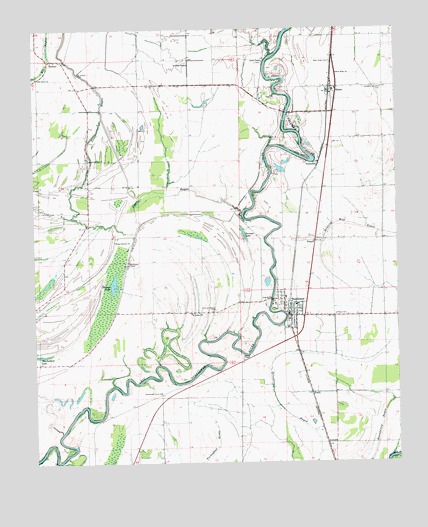
Sunflower, MS USGS Topographic Map
Click on map above to begin viewing in our Map Viewer.

This topographic map contains these locations and features:
Feature Name Type Latitude Longitude GNIS ID View Map
Bear BayouStreamN33.5093°W90.6159°666632View Map
Bearden Brothers Pond DamDamN33.5168°W90.5318°682162View Map
Bearden Brothers Pond DamDamN33.5518°W90.5468°682199View Map
Binson LakeLakeN33.5514°W90.5976°667177View Map
BlainePopulated PlaceN33.6079°W90.5226°667259View Map
Blaine Baptist ChurchChurchN33.6084°W90.5243°686474View Map
Blaine Methodist ChurchChurchN33.6168°W90.5223°707727View Map
Blaine SchoolSchoolN33.6073°W90.5218°686475View Map
Church of God (historical)ChurchN33.5593°W90.6151°686489View Map
Duncan ChapelChurchN33.5298°W90.5537°669505View Map
DwyerPopulated PlaceN33.5643°W90.5287°669533View Map
East Sunflower SchoolSchoolN33.5457°W90.5348°707734View Map
FurryPopulated PlaceN33.5204°W90.5298°691875View Map
Gorman LakeLakeN33.5661°W90.5526°670541View Map
InwoodPopulated PlaceN33.5060°W90.5248°691960View Map
Jacob ChapelChurchN33.6159°W90.5470°671793View Map
Jones BayouStreamN33.5715°W90.5540°671956View Map
Kates School (historical)SchoolN33.5712°W90.5629°686532View Map
King Solomon ChurchChurchN33.5643°W90.5976°672168View Map
King Solomon School (historical)SchoolN33.5640°W90.5973°686534View Map
McKinney ChapelChurchN33.5585°W90.5931°673387View Map
Mount Carey Church (historical)ChurchN33.5796°W90.5287°686551View Map
New Hope Baptist ChurchChurchN33.6118°W90.5206°674716View Map
New Hope CemeteryCemeteryN33.6148°W90.5229°674660View Map
New Macedonia Church (historical)ChurchN33.5593°W90.6243°686565View Map
O'Neal CemeteryCemeteryN33.5426°W90.5167°675000View Map
Oak Grove ChurchChurchN33.6112°W90.6234°675053View Map
PentecostPopulated PlaceN33.5848°W90.5287°692135View Map
Persimmon Grove ChurchChurchN33.5204°W90.5820°675633View Map
Pine LandPopulated PlaceN33.5487°W90.5404°707759View Map
RoundawayPopulated PlaceN33.5848°W90.6062°707767View Map
Roundaway ChurchChurchN33.5876°W90.6062°676919View Map
Roundaway School (historical)SchoolN33.5807°W90.6065°686586View Map
Saint James CemeteryCemeteryN33.6121°W90.6098°677023View Map
Saint James Church (historical)ChurchN33.6112°W90.6084°686596View Map
Saint Johns ChapelChurchN33.6148°W90.5731°677075View Map
Saint Johns School (historical)SchoolN33.6143°W90.5712°686597View Map
Saint Peters ChurchChurchN33.5435°W90.5715°677245View Map
Sixteenth Section CemeteryCemeteryN33.6079°W90.5048°677860View Map
Sixteenth Section School (historical)SchoolN33.6071°W90.5045°707772View Map
SteinerPopulated PlaceN33.6162°W90.6179°678267View Map
SunflowerPopulated PlaceN33.5429°W90.5370°678411View Map
Sunflower CountyCivilN33.6023°W90.5886°695787View Map
Sunflower Police DepartmentBuildingN33.5426°W90.5365°2754206View Map
Sunflower Post OfficePost OfficeN33.5426°W90.5370°2768594View Map
Sunflower Town Fire DepartmentBuildingN33.5426°W90.5377°2665716View Map
Supervisor District 3CivilN33.5032°W90.5909°712082View Map
Supervisor District 4CivilN33.6154°W90.6023°712083View Map
Town of SunflowerCivilN33.5443°W90.5373°2406690View Map
Turner Arant Pond DamDamN33.6001°W90.5551°682234View Map
Turner Arant Pond DamDamN33.6068°W90.5551°682240View Map
Union Grove ChurchChurchN33.5643°W90.5248°686618View Map
Willing Worker CemeteryCemeteryN33.5446°W90.5637°679729View Map

Note: Coordinates in the location and feature list above are referenced to NAD83 datum.


Copyright (C) 2008-2024 Ryan Niemi / Sunset Dynamics ... All Rights Reserved