TopoQuest Logo
Do you find TopoQuest useful?
Help keep TopoQuest running and adding new maps/features by donating!
Bitcoin:  19c7KJd3qBynnjoSw5npx9KScwjBe4ifkT
Litecoin:  LXs6TkuXGGXo1vDsWCkWVdjQX94eUKd6ui
Home View Maps Find Maps Find Places Resources & Links


Summersville, Kentucky Topographic Map

USGS Map Title: Summersville, KY
USGS Map MRC: 37085C5
DRG (GeoTIFF) Download: o37085c5.tif


Neighboring USGS Topographic Map Quads:


  Magnolia, KY  
37085D6
 

  Hibernia, KY  
37085D5
 

  Saloma, KY  
37085D4
 

  Hudgins, KY  
37085C6
 

  Summersville, KY  
37085C5
 

  Greensburg, KY  
37085C4
 

  Center, KY  
37085B6
 

  Exie, KY  
37085B5
 

  Gresham, KY  
37085B4


Map MRC Location:

N38°
W86°
N38°
W85°
H8 H7 H6 H5 H4 H3 H2 H1
G8 G7 G6 G5 G4 G3 G2 G1
F8 F7 F6 F5 F4 F3 F2 F1
E8 E7 E6 E5 E4 E3 E2 E1
D8 D7 D6 D5 D4 D3 D2 D1
C8 C7 C6 C5 C4 C3 C2 C1
B8 B7 B6 B5 B4 B3 B2 B1
A8 A7 A6 A5 A4 A3 A2 A1
N37°
W86°
N37°
W85°

Summersville, KY USGS 1:24K Topographic Map Preview:
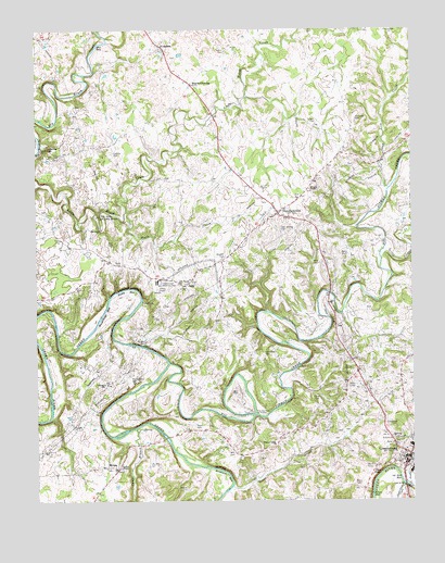
Summersville, KY USGS Topographic Map
Click on map above to begin viewing in our Map Viewer.

This topographic map contains these locations and features:
Feature Name Type Latitude Longitude GNIS ID View Map
Akin BendBendN37.2824°W85.5586°2742725View Map
Akin CemeteryCemeteryN37.2789°W85.5580°485809View Map
AllendalePopulated PlaceN37.3712°W85.5830°507387View Map
Beaverhouse HoleLakeN37.3003°W85.6025°486635View Map
Bell CemeteryCemeteryN37.2626°W85.5594°486786View Map
Bennett CemeteryCemeteryN37.3142°W85.5622°486856View Map
Big Pitman CreekStreamN37.2867°W85.5808°487227View Map
Bloyds CrossingPopulated PlaceN37.3606°W85.5727°507529View Map
Blue HoleBasinN37.3712°W85.6041°487518View Map
Brush Creek Baptist ChurchChurchN37.3434°W85.6230°488082View Map
Buzzards BluffCliffN37.3066°W85.5938°2742726View Map
Camp BranchStreamN37.2692°W85.5922°488678View Map
Caney FlatFlatN37.3027°W85.5946°2742727View Map
Cave Springs CemeteryCemeteryN37.3223°W85.5436°489142View Map
Caven CemeteryCemeteryN37.2770°W85.5308°489145View Map
Chaudoin CemeteryCemeteryN37.3512°W85.5186°489377View Map
Clover Lick CreekStreamN37.2539°W85.5033°489706View Map
DeWitt CemeteryCemeteryN37.3509°W85.5311°490715View Map
Dixie CreekStreamN37.3248°W85.5955°490919View Map
Factory SpringSpringN37.3438°W85.6205°2742729View Map
GabePopulated PlaceN37.3078°W85.5741°508056View Map
Glenview SchoolSchoolN37.2812°W85.6025°492913View Map
Goose CreekStreamN37.2534°W85.5011°493018View Map
Green CountyCivilN37.2641°W85.5531°516890View Map
Green County Sheriff's OfficeBuildingN37.2611°W85.5036°2767646View Map
Greensburg Police DepartmentBuildingN37.2624°W85.5019°2767626View Map
Halls CemeteryCemeteryN37.3153°W85.5211°493600View Map
Hamilton CemeteryCemeteryN37.2889°W85.5494°493617View Map
Hodges ChapelChurchN37.3326°W85.5339°494336View Map
Horse Shoe BendBendN37.3046°W85.5934°2742731View Map
Kidwell CemeteryCemeteryN37.2528°W85.5752°495722View Map
Kings HoleBasinN37.2514°W85.5133°495762View Map
Ladies ChapelChurchN37.2587°W85.5972°495902View Map
Little Pitman CreekStreamN37.3142°W85.5100°496827View Map
Milby CemeteryCemeteryN37.3128°W85.5305°498176View Map
Milby CemeteryCemeteryN37.3128°W85.5989°498177View Map
Montgomery CemeteryCemeteryN37.2831°W85.5936°498503View Map
Moss CemeteryCemeteryN37.2698°W85.5722°498670View Map
Noe CemeteryCemeteryN37.3181°W85.6011°499498View Map
Oak Forest ChurchChurchN37.3076°W85.5755°499654View Map
Oil Well HoleBasinN37.2559°W85.5036°499790View Map
Paddy HoleLakeN37.3062°W85.5944°500102View Map
Perkins CemeteryCemeteryN37.3426°W85.5994°500411View Map
Pleasant Ridge ChurchChurchN37.2645°W85.5450°500894View Map
Rockhouse HoleLakeN37.2573°W85.5619°502208View Map
Sand Lick ChurchChurchN37.3748°W85.5080°502929View Map
Sand Lick CreekStreamN37.3326°W85.5075°502931View Map
SummersvillePopulated PlaceN37.3262°W85.5444°504784View Map
Summersville Census Designated PlaceCensusN37.3265°W85.5430°2629687View Map
Summersville DivisionCivilN37.3598°W85.5954°1937282View Map
Summersville Volunteer Fire DepartmentBuildingN37.3361°W85.5566°2637025View Map
The DripSpringN37.2574°W85.5115°505118View Map
The Narrows of PitmanGapN37.2728°W85.5522°505138View Map
The Sinks of Little BrushBasinN37.3256°W85.6036°505145View Map
Trace CreekStreamN37.2534°W85.5600°505421View Map
Vance CemeteryCemeteryN37.3695°W85.5614°505967View Map
Vaughn CemeteryCemeteryN37.2920°W85.5908°505992View Map
WAKY-AM (Greensburg)TowerN37.2595°W85.5158°517818View Map
WebbsPopulated PlaceN37.2589°W85.6019°509328View Map
WGRK-FM (Greensburg)TowerN37.2595°W85.5158°517949View Map

Note: Coordinates in the location and feature list above are referenced to NAD83 datum.


Copyright (C) 2008-2024 Ryan Niemi / Sunset Dynamics ... All Rights Reserved