TopoQuest Logo
Do you find TopoQuest useful?
Help keep TopoQuest running and adding new maps/features by donating!
Bitcoin:  19c7KJd3qBynnjoSw5npx9KScwjBe4ifkT
Litecoin:  LXs6TkuXGGXo1vDsWCkWVdjQX94eUKd6ui
Home View Maps Find Maps Find Places Resources & Links


Gresham, Kentucky Topographic Map

USGS Map Title: Gresham, KY
USGS Map MRC: 37085B4
DRG (GeoTIFF) Download: o37085b4.tif


Neighboring USGS Topographic Map Quads:


  Summersville, KY  
37085C5
 

  Greensburg, KY  
37085C4
 

  Campbellsville, KY  
37085C3
 

  Exie, KY  
37085B5
 

  Gresham, KY  
37085B4
 

  Cane Valley, KY  
37085B3
 

  East Fork, KY  
37085A5
 

  Gradyville, KY  
37085A4
 

  Columbia, KY  
37085A3


Map MRC Location:

N38°
W86°
N38°
W85°
H8 H7 H6 H5 H4 H3 H2 H1
G8 G7 G6 G5 G4 G3 G2 G1
F8 F7 F6 F5 F4 F3 F2 F1
E8 E7 E6 E5 E4 E3 E2 E1
D8 D7 D6 D5 D4 D3 D2 D1
C8 C7 C6 C5 C4 C3 C2 C1
B8 B7 B6 B5 B4 B3 B2 B1
A8 A7 A6 A5 A4 A3 A2 A1
N37°
W86°
N37°
W85°

Gresham, KY USGS 1:24K Topographic Map Preview:
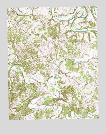
Gresham, KY USGS Topographic Map
Click on map above to begin viewing in our Map Viewer.

This topographic map contains these locations and features:
Feature Name Type Latitude Longitude GNIS ID View Map
Bethlehem ChurchChurchN37.2089°W85.4736°487021View Map
Blue Spring BranchStreamN37.1792°W85.4280°487544View Map
BramlettPopulated PlaceN37.1620°W85.4619°507573View Map
Caney ForkStreamN37.1698°W85.4347°488867View Map
Cedartop SchoolSchoolN37.1795°W85.3794°489254View Map
Coffey CemeteryCemeteryN37.1564°W85.4780°489776View Map
Ebenezer SchoolSchoolN37.2106°W85.4419°491542View Map
FryPopulated PlaceN37.1467°W85.4883°508048View Map
GreshamPopulated PlaceN37.1967°W85.4502°508135View Map
Gresham DivisionCivilN37.1777°W85.4693°1937037View Map
Hancock CemeteryCemeteryN37.1801°W85.4486°493670View Map
Hartfield CemeteryCemeteryN37.1806°W85.4905°493840View Map
HaskingsvillePopulated PlaceN37.1870°W85.3952°508202View Map
HatcherPopulated PlaceN37.1532°W85.3941°2743215View Map
Henderson CemeteryCemeteryN37.1464°W85.3927°494033View Map
Howard SchoolSchoolN37.1364°W85.4986°494675View Map
Ingram CemeteryCemeteryN37.1651°W85.3977°494990View Map
Jane Todd Crawford Memorial HospitalHospitalN37.2429°W85.4948°2660384View Map
KempPopulated PlaceN37.1364°W85.4580°508377View Map
Lemon BendBendN37.2284°W85.3850°496283View Map
Lemon Bend ChurchChurchN37.2326°W85.3866°496284View Map
Liberty ChurchChurchN37.1964°W85.4455°496371View Map
Miller ChapelChurchN37.2420°W85.4233°498334View Map
Morrison BranchStreamN37.1573°W85.4308°498626View Map
Mount GileadPopulated PlaceN37.1731°W85.3841°508642View Map
Mount Moriah ChurchChurchN37.1903°W85.4502°498778View Map
New Cedar Grove SchoolSchoolN37.1442°W85.4061°499297View Map
New CemeteryCemeteryN37.2095°W85.4730°499298View Map
Old CemeteryCemeteryN37.2076°W85.4708°499812View Map
Orr CemeteryCemeteryN37.1392°W85.4600°500002View Map
Penitentiary BendBendN37.2451°W85.3964°500377View Map
Pleasant Hill SchoolSchoolN37.2031°W85.4141°500877View Map
RoachvillePopulated PlaceN37.2406°W85.4236°508945View Map
Skinhouse BranchStreamN37.1881°W85.3950°503608View Map
Smith BranchStreamN37.1926°W85.3769°503739View Map
Snake BranchStreamN37.1653°W85.4697°503836View Map
South Fork Russell CreekStreamN37.1817°W85.4961°503945View Map
Sulphur Fork CreekStreamN37.1381°W85.4705°504738View Map
Summershade SchoolSchoolN37.1556°W85.4566°504783View Map
Thompson CemeteryCemeteryN37.1703°W85.4075°505194View Map
Wilson CemeteryCemeteryN37.2178°W85.4177°506886View Map

Note: Coordinates in the location and feature list above are referenced to NAD83 datum.


Copyright (C) 2008-2024 Ryan Niemi / Sunset Dynamics ... All Rights Reserved