TopoQuest Logo
Do you find TopoQuest useful?
Help keep TopoQuest running and adding new maps/features by donating!
Bitcoin:  19c7KJd3qBynnjoSw5npx9KScwjBe4ifkT
Litecoin:  LXs6TkuXGGXo1vDsWCkWVdjQX94eUKd6ui
Home View Maps Find Maps Find Places Resources & Links


Strang, Oklahoma Topographic Map

USGS Map Title: Strang, OK
USGS Map MRC: 36095D2
DRG (GeoTIFF) Download: o36095d2.tif


Neighboring USGS Topographic Map Quads:


  White Oak, OK  
36095E3
 

  Big Cabin, OK  
36095E2
 

  Ketchum, OK  
36095E1
 

  Adair, OK  
36095D3
 

  Strang, OK  
36095D2
 

  Spavinaw, OK  
36095D1
 

  Pryor, OK  
36095C3
 

  Salina, OK  
36095C2
 

  Salina SE, OK  
36095C1


Map MRC Location:

N37°
W96°
N37°
W95°
H8 H7 H6 H5 H4 H3 H2 H1
G8 G7 G6 G5 G4 G3 G2 G1
F8 F7 F6 F5 F4 F3 F2 F1
E8 E7 E6 E5 E4 E3 E2 E1
D8 D7 D6 D5 D4 D3 D2 D1
C8 C7 C6 C5 C4 C3 C2 C1
B8 B7 B6 B5 B4 B3 B2 B1
A8 A7 A6 A5 A4 A3 A2 A1
N36°
W96°
N36°
W95°

Strang, OK USGS 1:24K Topographic Map Preview:
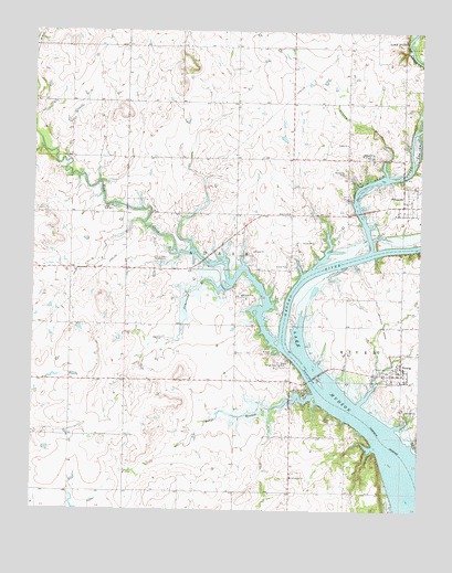
Strang, OK USGS Topographic Map
Click on map above to begin viewing in our Map Viewer.

This topographic map contains these locations and features:
Feature Name Type Latitude Longitude GNIS ID View Map
Armstrong BranchStreamN36.4343°W95.1858°1089699View Map
Benge BranchStreamN36.4054°W95.1589°1090003View Map
Benge CemeteryCemeteryN36.4132°W95.1707°1090004View Map
Big Cabin CreekStreamN36.4459°W95.1414°1090100View Map
Cabin Creek Fire DepartmentBuildingN36.4562°W95.1283°2657152View Map
City of Adair WaterworksLocaleN36.4395°W95.2086°1101998View Map
Elm CreekStreamN36.4662°W95.1272°1092578View Map
Ghormley CemeteryCemeteryN36.4634°W95.1495°1093173View Map
Grand Isle AirportAirportN36.4260°W95.1707°2676467View Map
Granny BranchStreamN36.4629°W95.1361°1093315View Map
Greenbriar ChurchChurchN36.3840°W95.1658°1093383View Map
PensacolaPopulated PlaceN36.4551°W95.1305°1096543View Map
Rock CreekStreamN36.4179°W95.1702°1097334View Map
Rock Creek ChurchChurchN36.4520°W95.1666°1097344View Map
Stearmans Roost AirportAirportN36.4888°W95.1352°1102720View Map
StrangPopulated PlaceN36.4106°W95.1308°1098578View Map
Strang Fire DepartmentBuildingN36.4104°W95.1336°2656971View Map
Strang Police DepartmentBuildingN36.4104°W95.1321°2757929View Map
Strang Post OfficePost OfficeN36.4108°W95.1328°1818774View Map
Town of PensacolaCivilN36.4556°W95.1292°2413125View Map
Town of StrangCivilN36.4122°W95.1345°2413339View Map
Township of AdairCivilN36.4418°W95.1947°1824563View Map
Utopia ChurchChurchN36.4706°W95.1486°1099199View Map

Note: Coordinates in the location and feature list above are referenced to NAD83 datum.


Copyright (C) 2008-2024 Ryan Niemi / Sunset Dynamics ... All Rights Reserved