TopoQuest Logo
Do you find TopoQuest useful?
Help keep TopoQuest running and adding new maps/features by donating!
Bitcoin:  19c7KJd3qBynnjoSw5npx9KScwjBe4ifkT
Litecoin:  LXs6TkuXGGXo1vDsWCkWVdjQX94eUKd6ui
Home View Maps Find Maps Find Places Resources & Links


Stancils Chapel, North Carolina Topographic Map

USGS Map Title: Stancils Chapel, NC
USGS Map MRC: 35078F2
DRG (GeoTIFF) Download: o35078f2.tif


Neighboring USGS Topographic Map Quads:


  Zebulon, NC  
35078G3
 

  Middlesex, NC  
35078G2
 

  Bailey, NC  
35078G1
 

  Flowers, NC  
35078F3
 

  Stancils Chapel, NC  
35078F2
 

  Lucama, NC  
35078F1
 

  Selma, NC  
35078E3
 

  Kenly West, NC  
35078E2
 

  Kenly East, NC  
35078E1


Map MRC Location:

N36°
W79°
N36°
W78°
H8 H7 H6 H5 H4 H3 H2 H1
G8 G7 G6 G5 G4 G3 G2 G1
F8 F7 F6 F5 F4 F3 F2 F1
E8 E7 E6 E5 E4 E3 E2 E1
D8 D7 D6 D5 D4 D3 D2 D1
C8 C7 C6 C5 C4 C3 C2 C1
B8 B7 B6 B5 B4 B3 B2 B1
A8 A7 A6 A5 A4 A3 A2 A1
N35°
W79°
N35°
W78°

Stancils Chapel, NC USGS 1:24K Topographic Map Preview:
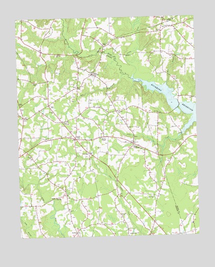
Stancils Chapel, NC USGS Topographic Map
Click on map above to begin viewing in our Map Viewer.

This topographic map contains these locations and features:
Feature Name Type Latitude Longitude GNIS ID View Map
Antioch ChurchChurchN35.6932°W78.2444°980234View Map
Antioch Volunteer Fire DepartmentBuildingN35.6951°W78.2459°2638432View Map
Beaverdam CreekStreamN35.7477°W78.1644°980851View Map
Bethany ChurchChurchN35.6399°W78.2147°981080View Map
Bethany Volunteer Fire DepartmentBuildingN35.6317°W78.2131°2639312View Map
Buckhorn ReservoirReservoirN35.7087°W78.1516°982147View Map
Bull BranchStreamN35.7177°W78.1747°982199View Map
Center Ridge ChurchChurchN35.6371°W78.1783°982941View Map
ConnorPopulated PlaceN35.7421°W78.1483°1006165View Map
Creechs ChurchChurchN35.6713°W78.2408°983731View Map
Crockers NubPopulated PlaceN35.6968°W78.1806°983756View Map
Dixie CrossroadsPopulated PlaceN35.6910°W78.2189°984220View Map
Evans BridgeBridgeN35.7302°W78.1897°1951490View Map
HeflinPopulated PlaceN35.7102°W78.2075°1006236View Map
Lamms PondSwampN35.7335°W78.2094°1951199View Map
Little CreekStreamN35.6813°W78.1378°1024093View Map
Little River Picnic AreaParkN35.6471°W78.2247°988757View Map
Mill BranchStreamN35.7121°W78.1453°989878View Map
Mizpah ChurchChurchN35.6788°W78.1692°990110View Map
Moccasin CreekStreamN35.7152°W78.1697°990118View Map
Moores ChapelPopulated PlaceN35.6821°W78.1900°990196View Map
Moores CrossroadsPopulated PlaceN35.6779°W78.1694°990202View Map
Mount Zion ChurchChurchN35.6954°W78.1511°990655View Map
New Jerusalem ChurchChurchN35.6727°W78.2008°991049View Map
Oak Grove ChurchChurchN35.7182°W78.1969°991382View Map
Pleasant Grove ChurchChurchN35.7443°W78.1453°992486View Map
Saint James ChurchChurchN35.6965°W78.2244°993913View Map
Saint Pauls Church (historical)ChurchN35.7490°W78.1489°1951222View Map
ShoeheelPopulated PlaceN35.6271°W78.2100°1024559View Map
Shoeheel CemeteryCemeteryN35.6277°W78.2103°1006111View Map
Southern Grove ChurchChurchN35.6474°W78.1558°995233View Map
Stancil ChapelChurchN35.7013°W78.2461°995399View Map
Stancils ChapelPopulated PlaceN35.6813°W78.2097°1022774View Map
Stilleys CrossroadsPopulated PlaceN35.7179°W78.1967°1022794View Map
Sylvia ChapelChurchN35.6990°W78.2261°995801View Map
Township of O'NealsCivilN35.7014°W78.2478°1026853View Map
Turkey CreekStreamN35.7157°W78.1686°996326View Map
Union ChapelChurchN35.7349°W78.1889°996435View Map
White Oak ChurchChurchN35.7293°W78.2214°997166View Map
Williamson ChapelChurchN35.7135°W78.2381°997402View Map

Note: Coordinates in the location and feature list above are referenced to NAD83 datum.


Copyright (C) 2008-2024 Ryan Niemi / Sunset Dynamics ... All Rights Reserved